The mission of NASA’s newest Earth satellite may sound simple, but its findings could have huge impacts across the world and right here in the Midwest. When it launched last month, the Soil Moisture Active Passive, or SMAP, began a three-year project to collect data on a key player in the water and carbon cycles that determine plant growth and drive weather patterns: soil moisture. IISG’s Michael Brennan has the details.
As the name suggests, soil moisture data tells us how much water the soil can absorb and store. These measurements play a crucial role in everything from knowing when to plant crops to community flood planning. If there isn’t enough moisture in the soil, plants can’t take root and grow. And if the soil’s storage capacity has been maxed out, any additional rain or snowfall will runoff into nearby rivers and lakes—carrying nutrients and contaminants with it.
Due to the earth’s vast landscape, tracking and assessing soil moisture is extremely challenging, especially in remote locations. In fact, a lack of detailed soil moisture data has historically been a significant hurdle for community planners, farmers, and climate and weather forecasters. SMAP has the potential to change all of that. Its microwave radiometer and radar instruments will give us the most accurate, high-resolution moisture data ever collected from space. And its orbital path will ensure we have measurements from pole to pole.
NASA has said that it expects to release the first set of measurements within nine months, with fully-validated data expected in 15 months. With these numbers in hand, farmers will be able to hone in on the ideal time for planing and harvesting and community decision makers will be able to pinpoint their flood risk—and plan accordingly. The data will also tell scientists how much carbon is being stored in or released by plants, allowing them to refine the climate models that we rely on to predict and prepare for the impacts of climate change.
The NASA space program is responsible for a lot of technological and scientific advancements, but SMAP may be its greatest contribution yet.
For more information on SNAP for video showing its launch and orbit, visit smap.jpl.nasa.gov/.
We talk a lot about the environmental benefits of sediment remediation. These are hard to miss—a trip to the river or harbor is often all it takes to confirm that the aquatic habitat is on the mend. The role of cleanup projects on local economies can be harder to pin down, but the impacts are just as striking. Brandon Steppan, IISG’s new communications intern, has the story.
I’ve lived in the city all my life. With the exception of a few parks and forest preserves, I never really saw environmental health as being all that connected to the welfare of my community. The only rivers that ever made the news were the Chicago River on St. Patrick’s Day and the Des Plaines River whenever it flooded—especially if that meant Gene and Jude’s, an iconic hot dog stand in River Grove and arguably the best place to get a Chicago-style hot dog, would have to shut down for repairs.
What I’ve learned about other Great Lakes communities in the short time I’ve been with IISG has already made me reevaluate just how valuable a healthy river can be—not just in terms of environmental integrity, but in dollars and cents. Results of economic studies of Great Lakes Areas of Concern (AOCs) have listed the values of what a clean waterbody would be for those communities, with numbers ranging from $6 million for one small neighborhood to $19 billion for all 31 original AOCs in the U.S. To get these numbers, economists and social scientists looked at money brought in from tourism, real estate values, and residents’ willingness to pay for a cleaner waterway.
One of the more remarkable returns came from a 2004 examination of the Waukegan Harbor AOC in Illinois. An analysis of housing data and resident perceptions determined that proximity to the PCB-ridden harbor substantially drove down property values. When surveyed, Waukegan homeowners revealed they would be willing to pay more for their property if it meant full cleanup of the harbor—a collective value of $436 million, much more than the projected cost for remediation.
My initial reaction to these reports was a mixture of confusion and surprise. But as I took into account the number of people in each area and how they rely on their local rivers not just for livelihood but for quality of life, the numbers no longer seemed all that surprising. The hazards of a toxic river bed aren’t always obvious, and unfortunately, neither are the benefits of remediation. Having these numbers available helps create a conversation where those benefits are no longer vaguely environmental, but economically tangible. ***Photo from the Waukegan Port District.
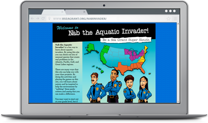
A closer look at web tools and sites that boost research and empower Great Lakes communities to secure a healthy environment and economy. Hundreds of invasive species are on the loose in U.S. waters wreaking havoc on habitats, recreation, and economies. Fortunately, a team of student detectives are on the case and ready to book these “bad guys” with help from Nab the Aquatic Invader! This educational website turns students grades 4-10 into PIs hot on the trail of some of the worst invaders in their region. After brushing up on detailed profiles complete with interrogation recordings, students take part in ongoing investigations led by veteran gumshoes. Whether they join as junior detectives or super sleuths, students learn to ID the suspects, expose the damage they cause, and stop invaders before they strike again. The site also includes a teacher Top Desk Administrator with example projects that give students a chance to share what they’ve learned with their communities. Along with detailed summary reports, these examples make it easy for teachers to plan and implement successful AIS stewardship projects in their own classroom. But you don’t have to go online to crack a case. A suite of card games and posters inspired by the website are also available. Students and adults alike can even join the hunt for the most wanted AIS at the Smithsonian National Museum of Natural History in D.C. and at Coastal Ecosystem Learning Centers throughout the country. Nab the Aquatic Invader! was created by IISG and Sea Grant programs in New York, Louisiana, Connecticut, and Oregon.
Three years after residents of Wauconda, IL approved a plan to transition to Lake Michigan water, the Lake County village has finally received the okay to build the infrastructure needed for delivery. Along with the nearby village of Volo, Wauconda is expected to begin tapping into the new source in 2018.
From the Chicago Tribune:
The agreement to deliver Lake Michigan water to Wauconda was a long time coming.
In 2012, Wauconda voters approved a $50 million plan to access Lake Michigan water, according to previous Tribune reports. But a deal with the water agency fell through in 2013, following a collapse in negotiations.
Talks started again in 2014, according to Tribune reports, with Wauconda and the agency reaching a deal early this year to deliver water to both Wauconda and Volo.
Now, planners are figuring out where to lay about 11 miles of new water pipe, said Darrell Blenniss, the joint water agency’s executive director. Read more
The move toward Lake Michigan water is important for Wauconda and Volo. Like many northeastern Illinois communities, these villages currently draw water from deep-rock aquifers that are being drained faster than they can recharge. Lake Michigan offers a more dependable supply for these growing communities. And because groundwater supplies can contain low levels of chemicals that drive up treatment costs, the switch may also prove more cost effective.
But transitioning aquifer-dependent communities to lake supplies is just one step towards securing long-term access to quality drinking water. Conservation is needed to ensure communities don’t pull more from the lake than federal law allows and to relieve some of the pressure on inland supplies.
That’s why IISG has teamed up with the Chicago Metropolitan Agency for Planning to help communities implement some of the key water supply management strategies laid out in the region’s Water 2050 plan. For example, we developed the Full-Cost Water Pricing Guidebook to help officials adopt prices that fully reflect water costs and encourage conservation. Margaret Schneemann, our water resource economist, has also helped planning groups and communities adopt lawn watering ordinances to curb inefficient outdoor water use.
To learn more about these and other efforts, visit our Water Supply page.
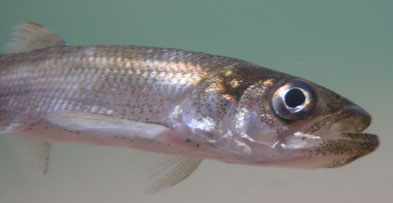
Fisheries managers have long known that the population of rainbow smelt in the Great Lakes is on the decline. Once so abundant that they could be fished out with a pot or strainer, this important prey fish survives today in numbers hovering near historic lows. Numerous causes for the falling population have been proposed, but new research suggests that the population patterns and the forces driving them are more complicated than previously believed.
The 2014 study reveals that number of smelt that survive their first few months has actually been on the rise since 2000. But this increase in hatchlings isn’t translating into more adults, and it is unclear when and why that breakdown is happening. Whatever the cause, the loss of adult rainbow smelt is enough keep the population trending down even as offspring survival improves.
Researchers from USGS, IISG, Purdue University, and the U.S. EPA Great Lakes National Program Office, discovered the unexpected increase in offspring after analyzing roughly 40 years of fisheries data using a novel modeling technique.
Fish populations are typically analyzed using a statistical model that that assumes the relationships between different variables—things like number of offspring, number of adults, degree of predatory pressure, and amount of rainfall—remain the same over time. For this study, researchers used statistical tools rarely used by fishery scientists that better reflect the ever-changing nature of the Great Lakes and make it possible to detect more subtle population patterns.
Perhaps most surprising is that offspring survival is on the rise in Lake Michigan despite the fact that their parents are up to 70 mm shorter now than they were in the 1970s.
“We were expecting to see a decrease in productivity because the adults are maturing at smaller sizes, which should mean fewer eggs and less healthy hatchlings,” said Zach Feiner, a PhD student at Purdue University and lead author of the study. “This raises a lot of questions about how well we understand rainbow smelt fisheries.”
Researchers speculate that the drop in the number of adult smelt may actually be allowing hatchlings to thrive. Adult rainbow smelt frequently supplement their diet of zooplankton by dining on their offspring. Fewer adults means fewer predators for juvenile smelt. The need to find food in a lake infested with millions of quagga and zebra mussels that filter out plankton may also be driving adults further out into the lake and away from spawning grounds.
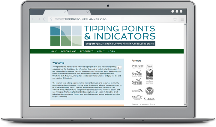
A closer look at web tools and sites that boost research and empower Great Lakes communities to secure a healthy environment and economy. For community planners, balancing community growth and environmental health can be a challenge. Putting down roads, building along waterways, or converting prairies to farmland puts stress on local ecosystems—sometimes so much that it can trigger rapid and potentially irreversible shifts in how they function. Fortunately, Tipping Points and Indicators gives watershed planning groups and others the information they need to avoid these tipping points while still meeting community needs. The web tool uses the latest watershed research and cutting-edge technology to show planners how close their watershed is to known tipping points and what the watershed will look like if land use decisions continue “business as usual.” Planners can also test how developing more in one location or restoring habitats in another moves ecosystems closer to or further from tipping points. With help from a Sea Grant facilitator, planners can use these interactive maps and simulators—along with recommended policies, ordinances, and outreach efforts—to prevent aquatic ecosystems from being degraded beyond repair. Since it was launched in 2013, Tipping Points and Indicators has undergone many design and feature updates inspired by months of pilot testing. Larger maps and detailed legends that toggle on and off give users a closer look at their watershed and make information on characteristics like stream quality and land cover types more accessible. Users can also easily track how proposed land use changes will effect ecosystem health with updates to the planning simulators. To learn more about the tool and see key features in action, watch this introductory video created by the IISG team leading the project.
Tipping Points and Indicators was developed in collaboration with Purdue University, University of Michigan, Michigan State University, University of Minnesota Duluth, University of Windsor, the Great Lakes Environmental Research Laboratory, the Cooperative Institute for Limnology and Ecosystem Research, the Great Lakes Restoration Initiative, NOAA, and the Sea Grant Great Lakes Network. Funding for the four-year project comes from NOAA and EPA.
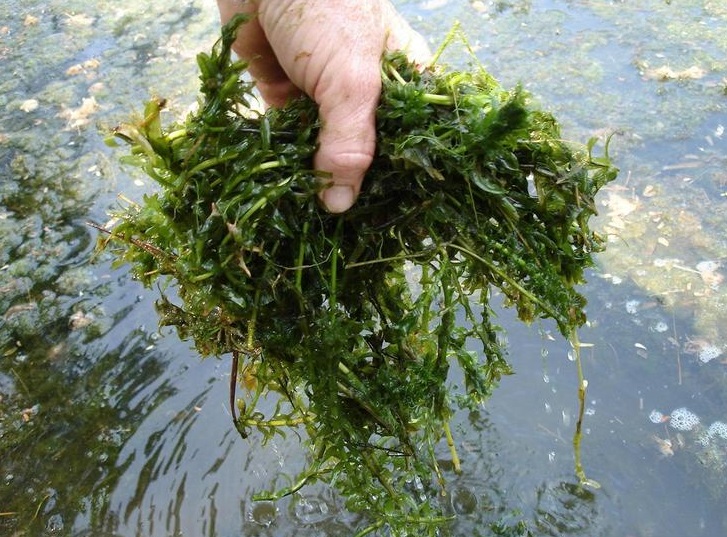
Water gardeners—keep your eyes open this season for invasive plants that may be lurking at your neighborhood garden store. In recent years, Illinois and Indiana DNR have both added nearly 30 new species to their lists of banned aquatic plants, but some may still be available for sale. If you spot one of these invaders, be sure to tell the store manager. Some species can be hard to identify and larger stores may not even know these plants are on their shipment list. That’s exactly what was happening at a Petco in Carbondale, IL, where Karla Gage found Brazilian elodea—aka Egeria densa—while browsing with her family.
“I notified the department manager that this was listed as an injurious species in Illinois, and I sent a follow up email to the store manager,” said Karla, coordinator of the River to River Cooperative Weed Management Area, which brings together federal, state, local, and private partners to tackle invasive plants in southern Illinois. “I received a call from the corporate contact, who stated that Petco stores in Illinois would no longer receive or be able to order Brazilian elodea. Previously, Carbondale stock had been on “auto-replenish,” so the stores never actually ordered Brazilian elodea.Current stock is being disposed of responsibly.”
“Thanks to Admin Code 805 and the quick response of Petco,” she added, “the risk of an introduction of Brazilian elodea into natural systems has been reduced.” The Illinois and Indiana rules also make it illegal to gift, barter, exchange, loan, or transport the any listed species. Recent additions to the list—27 plant species in Illinois and 28 in Indiana—were chosen based on the results of a risk assessment tool developed in Indiana by the Aquatic Plant Working Group. The tool evaluates species based on factors like ability to thrive in the Great Lakes and difficulty to control. IISG’s aquatic invasive species (AIS) team organized and facilitated the group, which included representatives from the aquatic plant industry, aquarium and water garden hobbyists, state agencies, academia, and non-governmental organizations.
Visit our AIS page for more information about invasive plants and animals on the market and what water gardeners and aquarium hobbyists can do to prevent their spread. ***Photo courtesy of Graves Lovell, Alabama Department of Conservation and Natural Resources, Bugwood.org.
A closer look at web tools and sites that boost research and empower Great Lakes communities to secure a healthy environment and economy.
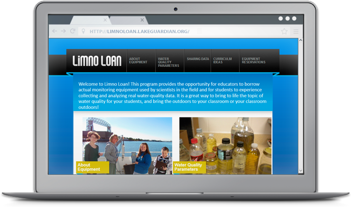
For over two years, the Limno Loan program has been shaking up science class across the Great Lakes region. Coordinated by IISG and the U.S. EPA Great Lakes National Program Office, the program gives students an opportunity to collect water quality data from local waterways with the same kind of monitoring sensors used by scientist aboard the R/V Lake Guardian. And now, teachers can take their Hydrolab projects one step further with help from IISG’s new Limno Loan site. In addition to information about the equipment and the parameters it measures, the site provides lessons and activities to help teachers K-12 better integrate the Hydrolab into their aquatic science sections.
The activities, most of which were created by educators who used the equipment in their own classrooms, focus on demonstrating the connections between water quality, aquatic food webs, and human activities. Sample water quality data sheets are also available. The website also provides a unique opportunity for classes to share their data and compare it to information collected by fellow students across the region.
New activities will be added as they are developed, so be sure to check back later. You can also read more about how the Limno Loan program has helped improve student understanding of Great Lakes sciences in our Winter 2012 Helm.
Managing aquatic invasive species is no easy—or cheap—task. Plants and animals spread to new regions through a variety of routes, many of which involve human activities like fishing, boating, and gardening. Coupled with the fact that there are hundreds of new species poised to thrive in Midwestern environments, it is very difficult for natural resource managers to get a jump on these invaders.
But all that may be changing in Illinois due to a new database cataloging the presence of non-native species across the state. Created at Loyola University Chicago by then-graduate student Abigail Jacobs and ecologist Reuben Keller, the database brings together animal and plant sightings collected by the U.S. Geological Survey, Field Museum, Illinois Natural History Survey, and many other organizations and researchers. Its more than 20,000 records makes it one of the most comprehensive AIS databases in country.
The size and detail of the database reveals previously-unknown patterns in the movement of invasive species that will help natural resource managers better focus their control and monitoring efforts.
“We now have maps showing the number of AIS in each county and showing where species tend to be first recorded,” said Keller. “These are really useful for determining where managers should focus on controlling existing invaders and where efforts should go into monitoring for new invaders.”
These maps and other analysis results are expected to be included in the updated Illinois State Comprehensive Management Plan for Aquatic Nuisance Species. First written in 1999, in part by IISG’s Pat Charlebois, the plan identifies invasive species that pose the greatest threat to the state and provides guidance for organizations working to halt their spread.
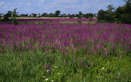
“The database will make it easier to connect with audiences by talking about how the specific waterways and habitats they care about are being affected by invasive species,” said Pat. ***Photo: Purple loosestrife is one of many invasive plants cataloged in the database.
What does a career in natural resources look like?
This month, a group of 4-H youth joined us at Martell Forest to find out! From tree climbing and birding to creating scent traps and dissecting owl pellets, participants spent three days exploring the many ways people work with and protect our natural resources.
Thanks to everyone who joined us! We can’t wait to see where your adventures take you next!

 The mission of NASA’s newest Earth satellite may sound simple, but its findings could have huge impacts across the world and right here in the Midwest. When it launched last month, the Soil Moisture Active Passive, or SMAP, began a three-year project to collect data on a key player in the water and carbon cycles that determine plant growth and drive weather patterns: soil moisture. IISG’s Michael Brennan has the details.