Category:

Nearshore buoy coming to Illinois summer 2015

December 2nd, 2014 by

A new environmental sensing buoy will be placed north of Chicago this summer, making it easier than ever for Illinois boaters and beach-goers to spend a fun, safe day on the water. 

Michigan City Buoy


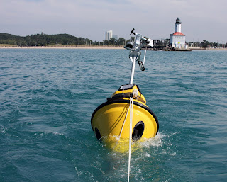
Like its counterpart in Michigan City, IN, the nearshore buoy will relay information on wave height and direction, wind speed, and air and surface water temperatures in near real time. A webcam will also make it possible to watch changing lake conditions first-hand.

 
This is the newest in a string of nearshore buoys along the Lake Michigan shoreline. In addition to allowing people track waves and temperatures, the data they collect will help officials warn beachgoers when contamination levels may make swimming unsafe. Researchers also rely on the real-time information to manage fisheries, monitor lake currents, and improve hazardous weather predictions.


The Illinois buoy, jointly operated by IISG and LimnoTech, is expected to go online in May. The project is funded by the Great Lakes Observing System through a grant from NOAA Coastal Storms. 

IISG Instagram

Science Sips is a series hosted by Illinois-Indiana Sea Grant, Sketchbook Brewing Company, and Northwestern University’s Center for Water that brings together researchers, scientists, and curious minds over good conversation and cold drinks. Each event features experts sharing their work in an accessible, informal setting. No lab coat required.At this gathering, Chicago author Dick Lanyon will take us back in time with a look at the history behind the construction of the Calumet and Chicago waterways and how these feats of engineering shape the region we live in today. Austin Happel from Shedd Aquarium will also share the latest research on fish communities in the Chicago River, including what the science is telling us right now about the health of this urban waterway.Stick around to test your Great Lakes knowledge with a round of trivia!Details at the link in bio.
A flooded street isn't just a local problem. When roads flood, the ripple effects reshape how an entire city moves, and IISG grad student scholar, Tianle Duan, is building the tools to track it in real time.Using remote sensing, aerial imagery, and AI, this Purdue PhD student maps flood impacts on road networks so first responders and city officials can act faster and smarter.🔗 Learn more about Tianle’s research at the link in bio.
Teaching plastic pollution? There’s more to it than the 3 Rs. @NAAEE’s Plastics eeResearch collection pulls together six studies on how to meaningfully educate students, from preschool through middle school, about plastic pollution.Research-backed, classroom-ready, and free to access.🔗 Link in bio📷 Photo credit: NOAA#TeachingTuesday #PlasticPollution #EnvironmentalEducation