Posted August 6th, 2015 in Buoys, Great Lakes Data
Boaters and beachgoers visiting the Chicago area this summer will have access to even more real-time data on lake conditions with a second nearshore environmental-sensing buoy that was launched in Lake Michigan on Tuesday, August 4, 2015.
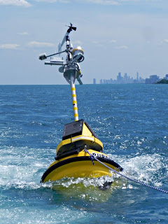
The new buoy, located roughly four miles off the coast of Wilmette, Ill., relays information on wind speed, air and water temperature, wave height and direction, and other environmental characteristics from May to October each year.
Tom Palmisano, an owner of Henry’s Sports and Bait shop in Chicago, volunteered his boat and time to take out the anchor portion of the buoy.
“The buoy will be useful for anybody who does anything on the water,” said Palmisano, a longtime commercial and recreational diver.
The Sheridan Shore Yacht Club in Wilmette donated use of their crane to lift the hulking sections — totaling over 600 pounds — into the water.
The TIDAS 900 Wilmette buoy is a joint project between Illinois-Indiana Sea Grant (IISG) and LimnoTech to help advance understanding of nearshore waters, alert the public to hazardous conditions in real time, and improve weather forecasts. Staff from Purdue University Civil Engineering also assisted on the project. This one is also equipped with a webcam enabling people to actually see the conditions on the lake.

“This is a tremendous leap forward,” said Ed Fenelon, a National Weather Service (NWS) meteorologist with the Chicago office. “Before this buoy, there was a data void in almost all of the nearshore area.”
Data from the first buoy launched in 2012 off the coast of Michigan City, Ind., has already led to adjustments in wave forecast models and boosted understanding of fisheries and nearshore dynamics.
Data from the Wilmette buoy will also be used to improve predictions of hazardous weather conditions and issue swim and small water craft advisories.
“To accurately forecast the future, you have to have a detailed measurement of current conditions,” Fenelon added. “This buoy will give us just that.”
Current lake conditions will be updated every 10 minutes and be available at the IISG Wilmette Buoy page. The mobile-friendly sites highlight conditions of particular interest to recreational users, such as wave height, wind speed, and surface water temperature.
Along with graphs showing trends over recent time periods, this information will tell boaters and kayakers when it’s safe to be on the water and help anglers target specific species.
“We have talked with many different groups in the area, from anglers and boaters to scientists, and the response to the buoy has been overwhelmingly positive,” said Jay Beugly, IISG aquatic ecology specialist. “People are excited that this information is so easily accessible.”
The Wilmette buoy was funded through the Great Lakes Observing System (www.glos.us), which is part of the National Oceanic and Atmospheric Administration’s (NOAA) greater Integrated Oceanic Observing System network.
Information collected from the buoys is also fed into the National Data Buoy Center (http://www.ndbc.noaa.gov/) operated by the National Oceanic and Atmospheric Administration and the more localized http://greatlakesbuoys.org/. Forecasters, researchers, and others can download raw historical data for Michigan City buoy ID 45170 or Wilmette buoy ID 45174 from any of these websites.

