A map of Great Lakes Areas of Concern in the United States
Areas of Concern are designated by the International Joint Commission as geographic areas in the Great Lakes basin having severe environmental degradation. There are 43 AOCs with 26 in the United States, 17 in Canada, and five shared by the two countries. An Area of Concern must have at least one beneficial use impairment, which means a reduction in the chemical, physical or biological integrity of the water body.

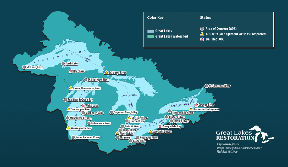
We all know the Great Lakes are big and beautiful, but you may not know that after decades of industry along their shores, many communities in the region have been left with polluted waterways and degraded waterfronts. Now that much of this manufacturing activity is gone, many of these Areas of Concern are being cleaned up through federal, state and local partnerships. Much of this work is funded through the Great Lakes Restoration Initiative.

Recently, National Geographic photographer Peter Essick spent some time documenting the sights, the people and the work taking place in these locations. These striking images provided an opportunity for the Great Lakes Sea Grant Network to tell some stories of restoration, revitalization and revival in this collective photo essay called Great Lakes Resurgence: Cleanup Efforts Bring Life to Local Waterfronts.

Great Lakes Resurgence: Cleanup Efforts Bring Life to Local Waterfronts

IISG Instagram

Got a research idea for southern Lake Michigan? IISG’s 2026 Seed Grant Research Competition is open. Up to $150,000 total funding for pilot studies that could become your next big project.💵 $10,000 to $50,000 per project⏰ Applications due August 17, 2026Two info webinars coming up: July 2 and July 21.🔗 Full details at the link in bio.
Add a Great Lakes twist to your summer reading! Discover stories inspired by our region with Great Lakes Great Reads. Check out reading lists perfect for beach days or quiet evenings.https://greatlakesgreatread.org/#BeachReads
Real-time coastlines, real-world insights. Check out the LIVE feed of Lake Michigan at Indiana Dunes State Park Beach – supporting recreationalists, researchers, and the broader public at the link in bio.This work is in partnership between Southeast Coastal Ocean Observing Regional Association (@secoora_org), the Great Lakes Observing System (@greatlakesobservingsystem), Indiana Dunes State Park (@indianadunessp), Indiana Department of Natural Resources (@indianadnr), and Illinois-Indiana Sea Grant with support from Surfline (@surfline).Check out IISG’s website for more information on this collaborative project at the link in bio. Also featured on Seagull and Indiana Coastal Atlas.Purdue Forestry and Natural ResourcesUniversity of Illinois ExtensionSouthern Lake Michigan Water Safety Task ForceUS National Weather Service Chicago IllinoisSave the DunesShirley Heinze Land TrustIndiana Dunes National ParkIndiana DunesFriends of Indiana Dunes, Inc.