A closer look at web tools and sites that boost research and empower Great Lakes communities to secure a healthy environment and economy.
For over two years, the Limno Loan program has been shaking up science class across the Great Lakes region. Coordinated by IISG and the U.S. EPA Great Lakes National Program Office, the program gives students an opportunity to collect water quality data from local waterways with the same kind of monitoring sensors used by scientist aboard the R/V Lake Guardian.
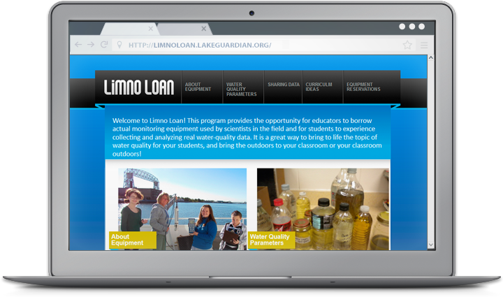
And now, teachers can take their Hydrolab projects one step further with help from IISG’s new Limno Loan site. In addition to information about the equipment and the parameters it measures, the site provides lessons and activities to help teachers K-12 better integrate the Hydrolab into their aquatic science sections.
The activities, most of which were created by educators who used the equipment in their own classrooms, focus on demonstrating the connections between water quality, aquatic food webs, and human activities. Sample water quality data sheets are also available. The website also provides a unique opportunity for classes to share their data and compare it to information collected by fellow students across the region.
New activities will be added as they are developed, so be sure to check back later. You can also read more about how the Limno Loan program has helped improve student understanding of Great Lakes sciences in our Winter 2012 Helm.
A closer look at web tools and sites that boost research and empower Great Lakes communities to secure a healthy environment and economy.
It’s getting a little chilly for a stroll in the Windy City, but don’t let that stop you from enjoying it’s beautiful downtown lakefront. With Chicago Water Walk, you can explore some of the city’s most celebrated sites—Navy Pier, the Chicago River, downtown marinas, Buckingham Fountain, and Museum Campus—from anywhere.
The mobile-friendly website takes viewers on a journey through time to discover how Lake Michigan and the Chicago River transformed a small trading post into one of the economic and cultural hubs of the world—and the vital role these natural resources play in the city’s present and future.
Each stop in the virtual tour combines history, current events, and water sciences with fun facts to show the importance of aquatic ecosystems in the city’s past, present, and future. Stunning photos, historical images, and links to videos and other resources bring these issues to life and reveal a lakefront that will surprise even lifelong Chicagoans.
Visit the website and you’ll learn why the decision to reverse the Chicago River is still making waves more than a century later, how a city that sits along Lake Michigan can be concerned about having enough water in the future, and how native trees and plants are helping the city prepare for changing weather patterns. You’ll also hear about efforts to restore much-needed habitats for millions of birds, fish, and other wildlife.
And for those willing to brave the cold, a mobile tour app is available for free on Apple devices. You can follow the suggested routes or visit the sites that most appeal to you using the app’s interactive map.
The Chicago Water Walk website and app were developed by Illinois-Indiana Sea Grant with funding from the Illinois Department of Natural Resources Coastal Management Program and technical support from the University of Illinois Administrative Information Technology Services.


