 Sea Grant Illinois-Indiana
Our Work Coastal Resilience Programs & Initiatives Shaping the Shoreline: Video Series
Shaping the Shoreline: Video Series
The Great Lakes coast is dynamic—it constantly changes due to natural and human processes, including lake level changes, erosion, storms and high waves, ice, increased development, and coastal flooding hazards. Through visualizations and expert interviews, the “Shaping the Shoreline” video series helps communities learn about natural processes and coastal protection structures, knowledge that is fundamental to fostering resilient southern Lake Michigan shores.
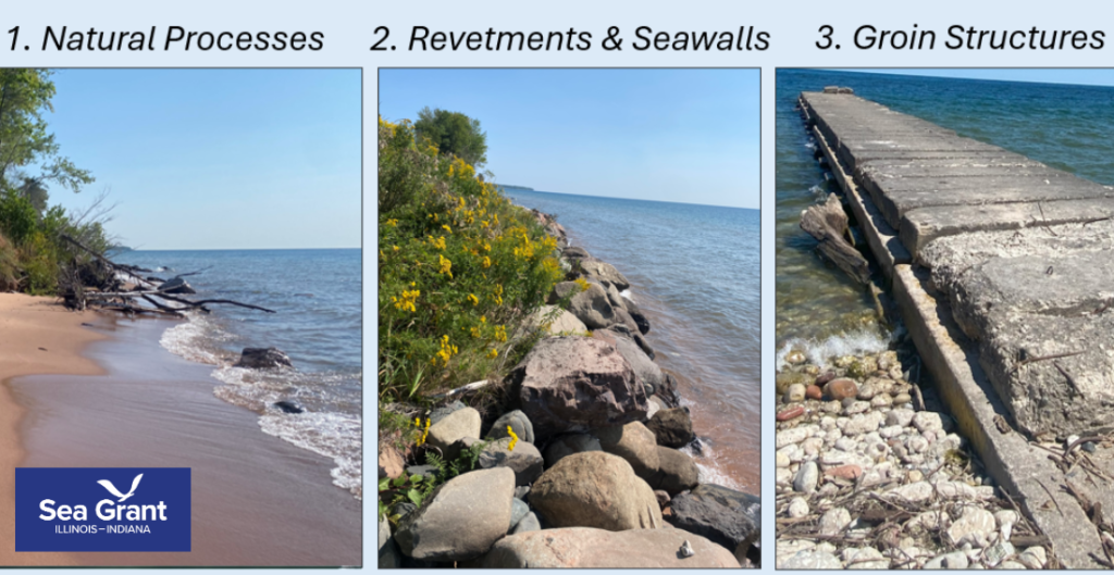
1. Natural Processes in the Great Lakes
Natural processes play a major role in shaping the coasts of the Great Lakes. This video highlights how different natural processes and coastal characteristics, such as water level, waves, sediment, and ice can transform the coast, which is an important aspect of resilient coastal decision-making.
2. Revetments and Seawalls in the Great Lakes
Revetments and seawalls, types of coastal structures that run parallel along the shore, are designed to stabilize and protect the coast against incoming wave action and erosion. While commonly implemented in the Great Lakes, revetments and seawalls interact with and alter natural processes, which may result in unintended physical, ecological, economic, and social impacts. This video discusses characteristics of revetment and seawall design, how they may contribute to shaping the coast, and considerations for long-term effectiveness.
3. Groin structures in the Great Lakes
Groin structures (also spelled groynes) are shore-perpendicular coastal structures that extend into the lake and are designed to build and maintain beaches through the trapping of sand. This video highlights characteristics of groin design, how they interface with natural processes and may impact the coast, and considerations for long-term effectiveness.
Funding and Acknowledgments:
This project was produced by Illinois-Indiana Sea Grant in collaboration with Purdue University, with financial assistance provided by under award NOAA-OAR-SG-2022-2007253 from the National Sea Grant College Program, National Oceanic and Atmospheric Administration (NOAA), U.S. Department of Commerce.
Illinois-Indiana Sea Grant
Production team: Sarah Peterson, Natty Morrison
Purdue University Brand Studio Productions
Director/producer/editor: TJ Preston
Purdue University Envision Center
Animation team: Vaughn Valentino, Jadden Picardal, Alex Troyer, Blake Edwards, George Takahashi, and Amanda Warren-Glowe
We thank the participating communities, agencies, experts, and local collaborators featured in this video series.
Interviewees
- Dr. Cary Troy | Purdue University
- Dr. Robin Mattheus | Delaware State Geological Survey (formerly Illinois State Geological Survey)
- Dr. Sarah Peterson | Illinois-Indiana Sea Grant/Purdue University
Reviewers
- Joe Exl | Indiana Lake Michigan Coastal Program
- Dr. Adam Bechle | Wisconsin Sea Grant
- Lydia Salus | Wisconsin Coastal Management Program
- Mark Breederland | Michigan Sea Grant
Contributions
- Beverly Shores
- Earthstar Geographics | Esri; U.S. Department of Commerce, Census Bureau; U.S. Department of Commerce (DOC), National Oceanic and Atmospheric Administration (NOAA), National Ocean Service (NOS), National Geodetic Survey (NGS)
- Esri, USGS | Esri, TomTom, Garmin, FAO, NOAA, USGS, EPA, USFWS
- Illinois State Geological Survey | Coastal Research Group
- Illinois Department of Natural Resources | Coastal Management Program
- Indiana Department of Natural Resources | Lake Michigan Coastal Program
- Joe Vandermeulen
- Josh Sonnenberg | Operations & Facilities Director, Charter Township of Chesterfield
- Liz Spitzer | Illinois State Geological Survey
- Michigan Sea Grant
- Mike Borkowski | DroNation Video Services
- National Oceanic and Atmospheric Administration, Office for Coastal Management
- Niemi, G.J. et al. 2007. Environmental indicators for the coastal region of the North American Great Lakes: Introduction and prospectus. Journal of Great Lakes Research 33(3): 1-12. Coastal Erosion. U.S. Climate Resilience
- Shoreline Oblique Photography Collection Courtesy of The Association of State Floodplain Managers. 2025. Wisconsin Shoreline Inventory and Oblique Photo Viewer. https://no.floods.org/wcmp. Photos by U.S. Army Corps of Engineers, Wisconsin Civil Air Patrol, and David Mickelson, with Association of State Floodplain Managers, GeoData@Wisconsin, and WisconsinView. Funded by the Wisconsin Coastal Management Program and the National Oceanic and Atmospheric Administration, Office for Coastal Management.
- State of Michigan Department of Environment, Great Lakes, and Energy
- Sterner, R.W. et al. 2017. Grand challenges for research in the Laurentian Great Lakes. Limnology and Oceanography 62: 2510-2523.
- Superior Watershed Partnership
- USA States Generalized Boundaries. U.S. Census Bureau. https://services.arcgis.com/P3ePLMYs2RVChkJx/arcgis/rest/services/USA_States_Generalized_Boundaries/FeatureServer/0
- U.S. Army Corps of Engineers
- U.S. Climate Resilience Toolkit. Accessed 10/30/2019. https://toolkit.climate.gov/topics/coastal-flood-risk/coastal-erosion
Learn more about Illinois-Indiana Sea Grant (IISG)’s Coastal Resilience Work: https://iiseagrant.org/work/coastal-resilience/
Learn more about Illinois-Indiana Sea Grant: https://iiseagrant.org
Contact Info
Topic Specialist
Research Projects
Publications
Education & Training
Related News
- Meet our Grad Student Scholars: Wei Wu
- Research opportunities can lead to better informed resource management
- Mapping the sand on Chicago beaches and in nearshore waters provides management insights
- Spelling out nature’s benefits helps inform land use decisions
- New research predicts potential flooding impacts on critical infrastructure