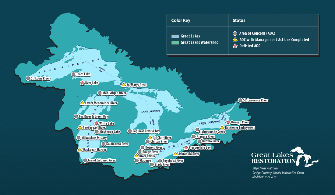
A map of Great Lakes Areas of Concern in the United States
Areas of Concern are designated by the International Joint Commission as geographic areas in the Great Lakes basin having severe environmental degradation. There are 43 AOCs with 26 in the United States, 17 in Canada, and five shared by the two countries. An Area of Concern must have at least one beneficial use impairment, which means a reduction in the chemical, physical or biological integrity of the water body.

We all know the Great Lakes are big and beautiful, but you may not know that after decades of industry along their shores, many communities in the region have been left with polluted waterways and degraded waterfronts. Now that much of this manufacturing activity is gone, many of these Areas of Concern are being cleaned up through federal, state and local partnerships. Much of this work is funded through the Great Lakes Restoration Initiative.

Recently, National Geographic photographer Peter Essick spent some time documenting the sights, the people and the work taking place in these locations. These striking images provided an opportunity for the Great Lakes Sea Grant Network to tell some stories of restoration, revitalization and revival in this collective photo essay called Great Lakes Resurgence: Cleanup Efforts Bring Life to Local Waterfronts.

Great Lakes Resurgence: Cleanup Efforts Bring Life to Local Waterfronts

IISG Instagram

🌊 Making Waves in Education Calling all K–12 educators — formal and non-formal! Stay connected to the Great Lakes and inspired in your teaching with our educator-focused newsletter.📬 Why Subscribe?✅ Discover teaching resources and professional development opportunities ✅ Connect with Sea Grant partners and community efforts✅ Bring Great Lakes science and stewardship into your classroom or program🗓️ Published quarterly — with occasional bonus issues when exciting events or new content arise!💡 Whether you’re in a classroom, nature center, or museum, this newsletter helps you make waves in education.👉 Sign up now: https://iiseagrant.org/education/subscribe-to-education-newsletter/ #TeachingTuesday#GreatLakesEducation
When participating in a crayfish participatory science activity, be sure to snap plenty of photos of any crayfish you catch or observe. Not only is it a great way to capture the fun and excitement of the day, but it also helps document the species present. To ensure accurate identification by scientists, it’s important to provide clear photos from multiple angles. Dorsal (top), lateral (side), and ventral (underside) views of the crayfish should always be photographed.To learn more about the specific features to highlight in your photos visit the link in bio or InvasiveCrayfish.org/Management/#Community
Who says “Back to School” means back indoors? While the weather is still warm, take your students on an outdoor science adventure by exploring crayfish in your local waterways.The Invasive Crayfish Collaborative invites grades 2-12 educators to take part in a hands-on participatory science activity. By catching, identifying, and reporting crayfish species in your area, students contribute valuable data that helps scientists better understand where native and invasive crayfish live.Check out what other educators have found and get involved: inaturalist.org/projects/great-lakes-crayfish
Skip to content