Meet Our Grad Student Scholars is a series from Illinois-Indiana Sea Grant (IISG) celebrating the graduate students doing research funded by the IISG scholars program. To learn more about our faculty and graduate student funding opportunities, visit our Fellowships & Scholarships page. Colleen O’Brien is a doctoral student in the McCormick School of Engineering at Northwestern University. She is currently in her fourth year in the program and her research looks at the performance of green infrastructure for flood reduction and water quality improvements. In the work funded by Illinois-Indiana Sea Grant, she investigates how urban green space may impact water temperature in the Chicago River. Her broader interests focus on how nature-based solutions can help cities adapt to climate change.
Cooler temperatures, better air quality, community spaces, and places to exercise – these are just a few of the environmental and social benefits that urban green spaces provide. More and more frequently, spaces like parks, gardens, and nature preserves are being relied upon by residents of urban areas for a host of benefits. One of these is stormwater management. Green infrastructure, which includes rain gardens, bioswales, and green roofs, can help reduce flooding and improve water quality. This is important as stormwater management will become an increasingly difficult problem to address as urbanization increases and effects of climate change, like warming temperatures or changing rainfall patterns, become a reality. However, many questions on the performance of green infrastructure remain. Understanding how the design of green infrastructure impacts its ability to reduce flooding and improve water quality is critical to ensure these spaces provide maximum benefits. That’s where monitoring and modeling come in.
Monitoring green infrastructure, for example with sensors that measure soil moisture, water level, and outflow from a given rain garden or bioswale, can help answer questions like, “Does the type of green infrastructure installed impact the amount of water that can be stored?” or “Do certain types of vegetation growing in a rain garden do a better job of improving water quality than others?”. But monitoring cannot address all the questions posed by scientists or urban planners, especially when aiming to expand an individual green infrastructure site to a regional scale. This is when modeling can help.
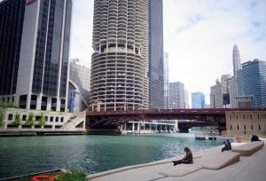
Along the Chicago River.
With support from Illinois-Indiana Sea Grant, Colleen O’Brien used ArcGIS, a mapping software, and the Minnesota Urban Heat Export Tool (MINUHET), a modeling software for thermal analysis of streams and rivers, to investigate the impact of green infrastructure and urban green spaces on water temperatures in the Chicago River. Water temperature is often called the master variable of water quality because it has a wide range of impacts on ecosystem health. Warmer water temperatures decrease the ability of water to hold chemicals like oxygen, can affect aquatic nutrient cycles, and can reduce the growth of fish and other organisms. Climate change, urbanization, and industrial and wastewater outflows have all contributed to increases in river water temperatures across the world, but this effect has been especially noticeable in cities.
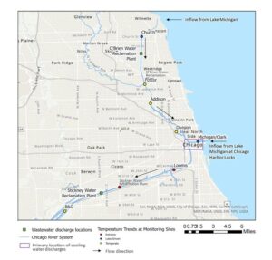
A map showing temperature data along the Chicago River.
In the Chicago region, particular concerns are that warmer water temperatures may cause more frequent algal blooms and may increase the spawning rates of invasive carp, several fish species that pose major risks to aquatic ecology and biodiversity. Green infrastructure has the potential to reduce thermal pollution, the degradation of water quality due to anthropogenic changes in water temperature. At a small scale, green infrastructures can reduce the temperature of stormwater runoff that flows into the Chicago River. At a larger scale, green infrastructure can reduce the amount of stormwater runoff overall and can help reduce the urban heat island effect, lowering the temperature of both stormwater and the air. However, due to different sizes and locations of green spaces in the urban area, the magnitude of these impacts on the changes in water temperature are still largely unknown.
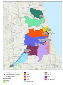
A map showing the outline of catchment areas used in the modeling exercises.
Using temperature data for the Chicago River collected by the Metropolitan Water Reclamation District of Greater Chicago from 2017-2021, O’Brien is able to determine the drivers of water temperature and investigate the impact of green spaces at different scales (i.e., small green spaces along the river bank versus large green spaces within the catchment area). She uses ArcGIS to delineate the catchment areas—the areas from which rainfall flows into a river, lake, or reservoir—for each temperature sensor and examine the amount of green space within each catchment, then assesses the land use and green space within the area directly along the river bank. Next, she uses the modeling software MINUHET to predict the temperature of stormwater from these areas based on physical characteristics and atmospheric conditions such as land use, slope, air temperature, and relative humidity. These results provide information on what types of green spaces may be most effective at reducing thermal pollution. This can be used to inform future restoration projects to reduce thermal pollution, a key step in restoring urban river ecosystems.
As the City of Chicago continues to grow and the effects of climate change intensify, the impact of thermal pollution is likely to increase. Degradation of the Chicago River has the potential to impact the quality of Lake Michigan, a vital source of drinking water for the region. Developing a better understanding of the sources of thermal pollution within the Chicago River can inform restoration efforts and the design of green infrastructure and prevent further environmental degradation. In addition, more green spaces can improve air quality, reduce urban heat, provide spaces for recreation and social gathering, among many other community benefits.
After completing her PhD, O’Brien plans to pursue a career focused on community science and science policy, working directly with community organizations to make cities more climate resilient.
Illinois-Indiana Sea Grant is a partnership between NOAA, University of Illinois Extension, and Purdue University Forestry and Natural Resources, bringing science together with communities for solutions that work. Sea Grant is a network of 34 science, education and outreach programs located in every coastal and Great Lakes state, Lake Champlain, Puerto Rico and Guam.
Contact: Carolyn Foley
