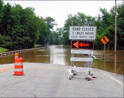
Enough rain fell in Texas over the past month to cover the entire state in more than eight inches of water. The Trinity River in Dallas has risen to levels not seen in over 25 years. Flooding has resulted in $45 million worth of damage in Houston alone, and at least 31 people have died, with 10 still missing. As recovery in the Lone Star State begins, it becomes clear just how important urban flood management is, not only for the safety of people, but for the health and well being of the environment. Next month, Chicago, no stranger to flooding itself, will be the host location to a workshop confronting these very issues.

On July 8, IISG climate specialist Molly Woloszyn will be overseeing the next Resilient Chicago workshop: Urban Flood Management through No Adverse Impact and Green Infrastructure.Following up on a workshop from last year, this free, one-day event offers local government staffers and other interested professionals the opportunity to learn how to prepare for flooding in a more efficient and ecologically-conscious way. City planners, engineers, and members of non-profit organizations are called to gather at Loyola University to hear presentations from the Association of State Floodplain Managers, the Metropolitan Planning Council, the City of Chicago, and many others.
The two primary foci of the workshop will be how to apply No Adverse Impact (NAI) floodplain management and integrating green infrastructure into comprehensive and capital improvement planning. By focusing on NAI floodplain management, the workshop will provide potential management solutions that can be applied from strictly flooding related problems to issues like water quality protection and stormwater management. And in showcasing the potential for green infrastructure, attendees will learn how to cope with the increased potential for soil saturation that comes with urban development. The workshop will be sponsored by ASFPM, and the NOAA Coastal Storms Program.
.
In July, the Taste of Chicago closed down for a day due to heavy rain. In the suburbs, storms are flooding streets and basements. It’s a rainy year—the month of June had the third highest rainfall at Chicago O’Hare since records have been kept in 1959.
City sewers built to take on storms from days gone by are no match for today’s rainfall that lands mostly on parking lots, streets, and sidewalks instead of being absorbed into fields and patches of forest. What’s more, climate change predictions appear to be coming true—larger storms are hitting more frequently.
Basements and streets underwater are a serious concern, but when Superstorm Sandy hit the east coast two years ago, it illustrated that flooding of critical facilities, such as hospitals, can have widespread and possibly catastrophic impacts.
IISG’s climate specialist, Molly Woloszyn, is tackling the issue of flooding from the angle of better preparation and prediction. She is part of a project that is assessing the flooding vulnerability of critical buildings in Chicago, including utility providers, transportation facilities, and hospitals. She is looking at factors like location, elevation, and flooding history of the facility, but also the placement of critical systems, such as generators and potable water supplies. Ultimately, this will result in recommendations on how these facilities can shore up their structures and systems to reduce this risk in the face of future storms.
Molly and other project contributors at the Midwestern Regional Climate Center are also dipping into 25 years of data from the Cook County Precipitation Network to connect large rain events with their consequences, such as combined sewer overflows and reports of basement and viaduct flooding. The goal here is to help the National Weather Service make forecasts that are impact-based for the city of Chicago.
Updating rain event reports for what constitutes a 5-year storm or a 100-year storm, for example, (meaning the probability of these storms happening is 1 in 5 or 1 in 100 years) is one part of the city’s plan for getting ahead of flooding concerns as detailed in the City of Chicago Green Stormwater Infrastructure Strategy. Planners and engineers use long term rainfall data to make decisions going forward, but the last report was released in 1992 with data up to the mid-80s. By all accounts, big storms are getting bigger and more frequent. More data is key for local decision makers. The Midwestern Regional Climate Center’s analysis of the Cook County data will provide new rainfall thresholds for various sized events over the course of the last 25 years.

