As 2019 draws to a close, I’m pleased to report that here at Illinois-Indiana Sea Grant, we’ve had a very good year, and that remained the case through the latter months.
In October, IISG underwent its program site review, which takes place every four years. Through this process, we presented our work from our last omnibus as well as our current activities to the external site review team. The review provides a great opportunity to reflect on our accomplishments and to look forward to new efforts.
The review team was very positive in its response, which, in large part, is due to not only the hard work of the IISG team, but also the great amount of support from our diverse partners, many of whom directly participated in the review.
This fall, we expanded our communication tools and products to share information about the Great Lakes with wider audiences. Inspired by a rich collection of photographs taken by Peter Essick, who works with National Geographic, IISG led the development of a photo essay called Great Lakes Resurgence about Areas of Concern in the region. The Great Lakes Sea Grant Network collaborated to tell the stories of these degraded waterways, to describe the progress of cleanup efforts and report local impacts of coastal restoration.
IISG now has a monthly podcast series, Teach Me about the Great Lakes, which debuted in December. Hosted by Stuart Carlton, the program’s assistant director, the podcast helps Stuart—and listeners—learn about the biology, ecology and natural history of the Great Lakes. Stuart is a social scientist who grew up in the south, so he is fairly new to Great Lakes issues. The first installment dove into concerns about microplastics, which have been found in the Great Lakes and many waterways all over the world. The next episode, available in early January, will focus on the geological history of the Great Lakes.
Autumn also brought awards season for the Sea Grant program, both regionally and nationally. We are proud of Pollution Prevention Specialist Sarah Zack, who was honored with the Great Lakes Sea Grant Network Early Career Award at the regional meeting in Sault St. Marie, Michigan. Irene Miles, strategic communication coordinator, won the Communications Service Award at the Sea Grant Extension Assembly, Communicator and Research Coordinator Conference in Savannah, Georgia. Also at the Savannah meeting, Brian Miller, IISG’s former director, was selected for the William Q. Wick Visionary Career Leadership Award, one of Sea Grant’s most prestigious honors.
As we all look forward to 2020, we wish you the best in the new year. For IISG, 2020 will bring an even greater focus to Lake Michigan. Scientists from around the Great Lakes basin will converge on the lake to conduct intensive research through the Cooperative Science and Monitoring Initiative (CSMI). IISG has just released an ESRI story map, Lake Michigan Health: A Deeper Dive, to share the results from the 2015 CSMI field year on Lake Michigan.
The Shipboard Science Workshop will also take place on Lake Michigan in the coming year. During this week-long workshop on the EPA research vessel the Lake Guardian, organized through the Center for Great Lakes Literacy, teachers from the region work side by side with scientists to study one of the Great Lakes. This coming year they set sail on Lake Michigan. We look forward to new science and stories that will emerge from both of these exciting initiatives.
Lake Michigan gets regular health checkups, but like many people, it sometimes needs special monitoring or scanning to get to the bottom of symptoms or concerns. The latest results from some of these tests and evaluations are now available in an Environmental Systems Research Institute Story Map, Lake Michigan Health: A Deeper Dive.
The Cooperative Science and Monitoring Initiative (CSMI) intensive examination of Lake Michigan occurs every five years through an initiative that rotates around the Great Lakes—scientists in the region coordinate their efforts to answer critical questions and fill science information gaps for each lake.
Each year since 2002, through CSMI, multiple federal, provincial, state, and university scientists have joined forces on one of the Great Lakes to take part in coordinated research. This binational program is organized through the U.S. Environmental Protection Agency Great Lakes National Program Office and Environment and Climate Change Canada in support of the Great Lakes Water Quality Agreement Science Annex.
Unlike your medical records, information on the health of Lake Michigan is available to everyone, including environmental managers, scientists, educators, students, boaters, anglers and lake enthusiasts in general. On the story map, information is presented through interactive graphics, easy-to-understand diagrams and photos of science in action.
“Having this straight-forward tool that helps us explain to anglers and other stakeholders how bottom-up factors affect fish populations is a great thing and very timely, given the changing Lake Michigan ecosystem,” said Vic Santucci, Lake Michigan program manager, Illinois Department of Natural Resources.
Lake Michigan: A Deeper Dive, which was developed by Illinois-Indiana Sea Grant, includes a brief history of the lake as well as information on several key areas of study from 2015—Lake Michigan’s most recent CSMI field year focusing on the lower food web, prey fish and contaminants.
The invasive quagga mussels featured prominently in the scientists’ reports. They found that their lakewide numbers have declined, but that quagga biomass has increased as mussels age and grow larger. In deeper parts of the lake, quagga mussel populations increased between 2010 and 2015.
One way that scientists can assess the number of quagga mussels on the lake bottom is using a towed benthic sled, which, equipped with a camera, visually records mussel distribution and numbers at the bottom of the lake. While visiting the CSMI story map, you can ride along on the benthic sled and see what the scientists saw. Also, Lake Michigan: A Deeper Dive provides graphic illustrations of how the lake food web has changed since the influx of invasive species.
Another key finding is that, in general, larval fish are growing about half as fast as they did before quagga mussels were established in the early 2000s. In fact, quagga mussels, by filtering large amounts of plankton, may be having a negative impact on fish production.
Next year, CSMI scientists will once again gather on Lake Michigan for monitoring and testing to assess the health of the lake. To set 2020’s research priorities, scientists and resource managers came together in 2018 to discuss the latest findings and to define critical data needs. Over the next couple of years, scientists will report the results of their fieldwork and the CSMI story map will be updated with information from this upcoming Lake Michigan checkup.
This project was supported by the Great Lakes Restoration Initiative.
Illinois-Indiana Sea Grant is a part of University of Illinois Extension and Purdue Extension.
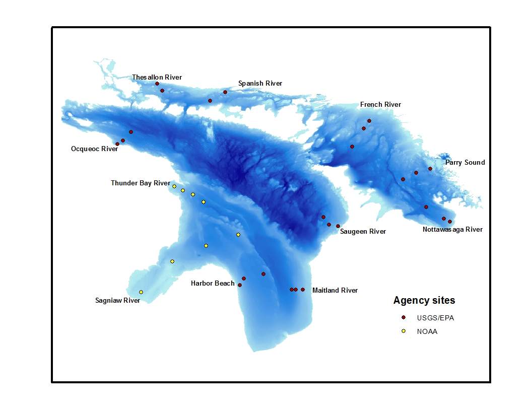
I’m aboard a 180-foot research vessel traversing Lake Huron; the ship is the U.S. EPA R/V Lake Guardian, and the goal is to take the pulse of this gaping freshwater entity. Every year the Cooperative Science and Monitoring Initiative (CSMI) comprehensively surveys one of the five Great Lakes. As a result, it’s been five years since we’ve taken a long look at Lake Huron.
Those working on this particular six-day research cruise vary from marine technicians who live on the ship for the whole sampling season, to scientists from the U.S. Environmental Protection Agency (EPA) and U.S. Geological Survey (USGS) onboard for the week to collect data and bring it back to their labs.
Left: A larval fish seen under a microscope. Right: The trawl net used to sample larval fish being pulled in over the sunrise.
And me?
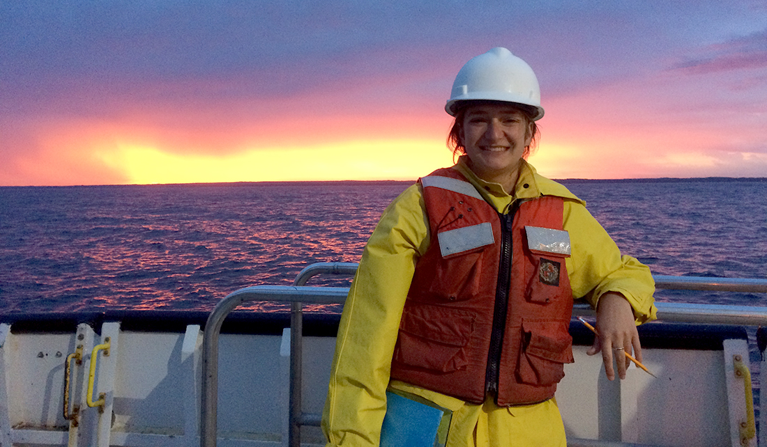
I’m here with IISG as the Great Lakes communication and outreach intern, helping out with the sampling and observing so that when I’m back on land, I can use this experience to enhance my translations of scientific studies from the 2015 CSMI survey of Lake Michigan to engaging, accessible outreach materials for policy makers, fisheries managers, and the general public.
Clark working on the fantail.
I am on the 4 a.m. to 4 p.m. shift of this around-the-clock undertaking. At 3:30 a.m., I’ve got to hastily get up and shuffle down the hall to relieve the night shift on the back deck. I pull on my rain boots, life jacket, and hardhat, then grab a clipboard to record the samples as they come in. There are six sampling sites to complete on this cruise, and each composes a “transect,” a narrow section of water which runs perpendicular to the shoreline, providing an offshore, mid-shore, and nearshore snapshot.
Each station has a sampling agenda. If a station is reached at night, this protocol begins by sampling benthic, shrimp-like animals known as Mysis under red light. If the sun has already risen, we use an extremely large and well-outfitted CTD—an instrument that measures conductivity, temperature, and depth as it is deployed through the water column.
Next up is the zooplankton sampling, followed by two ichthyoplankton tows to sample larval fishes—the early stage in a fish’s life history where they are mere millimeters in length, floating about eating the zooplankton we sampled just prior. The larval fish collected are separated from the various bycatch of flotsam and examined back at USGS headquarters for a variety of parameters including species, length, and age.
The age data, collected by examining growth increments on the larvae’s minute otoliths (inner ear bones), is reported in days old. I find them enormously cute, in an E.T.-without-legs kind of a way.
Map of the CSMI survey stations in Lake Huron. During this cruise Harbor Beach, Maitland River, Saugeen River, Nottawasaga River, Parry Sound, and French River transects were sampled, in that order.
After each of the three stations have been surveyed, a large sampling instrument called the Triaxus is towed back along the entire transect to gather information across the full survey area. Depending on the length of the transect, this can take a while.
I have found this a great time to hit the galley and grab a second or third breakfast, depending on the day. After all, by 9 a.m. I’ve been awake for a good five to six hours and there’s more sampling to do.
We then lower the Rosette, a big water sample collector, to measure the amount of chlorophyll in the water. We also put nets down six different times to collect zooplankton. We then used a big net to collect larval fish out the side or behind at different depths throughout the water column. We also towed the Triaxus for a few hours. We head to the next transect and do it all over again.
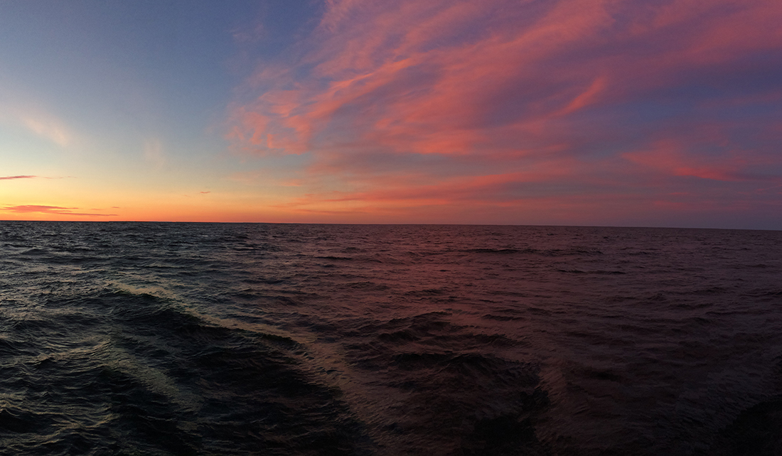
And—if we’re lucky—in exchange for all our hard work, the next time I crawl out of my bunk at 3 in the morning I get to witness a scene like this one:
Emily Clark is working with Paris Collingsworth and Kristin TePas as a summer intern with IISG where she is creating outreach materials for the results of the 2015 Lake Michigan CSMI field year. Clark is a student at College of Charleston in South Carolina studying biology, environmental studies, and studio art.
Illinois-Indiana Sea Grant is a part of University of Illinois Extension and Purdue University Extension.
This has been a good year for Illinois-Indiana Sea Grant. Working with our many partners, big projects reached their culmination, in some cases providing researchers and decision makers new ways to access data. And the spotlight was turned on Lake Michigan for research and education. Here are10 important stories from 2015.
The year started with big research news that southern Lake Michigan has high concentrations of plastic microfibers, which are likely from clothing that sheds in the wash. This news was picked up by media outlets around the world, including the Associated Press, The New York Times, The Guardian, and the Chicago Tribune.
2015 saw the release of the Illinois Nutrient Loss Reduction Strategy, which laid out a plan to reduce the flow of nutrients down the Mississippi River to the Gulf of Mexico. This strategy was developed with input from a range of stakeholders, including government agencies and agricultural producers.
Be a Hero is now the primary invasive species awareness campaign in Illinois. Recreational water users have heard this message, but now the campaign provides easy tips to help water gardeners, teachers, and aquarium hobbyists curb the spread of aquatic invaders. Plus, Be a Hero provides guidance to hunters, campers, and hikers to prevent the spread of species that threaten habitat on land.
The Grand Calumet River in Indiana just keeps getting better. Another section of this long polluted waterway has been cleaned up through Great Lakes Legacy Act funding and that of many local and state partners. Remediation of the Kennedy to Cline Avenues section led to the removal of 1.1 million cubic yards of contaminated sediment.
Twice this year, it was Lake Michigan’s turn for ongoing projects that rotate yearly around the Great Lakes. First, the Lake Michigan Cooperative Science and Monitoring Initiative (CSMI) brought together agencies and scientists to study the nearshore environment, which ultimately will help inform management decisions. CSMI is part of a larger binational effort to advance Great Lakes monitoring and research.
Second, this was the year for the Shipboard Science Workshop on Lake Michigan, in which 15 teachers spent a week aboard the U.S. EPA R/V Lake Guardian working with researchers and learning about Great Lakes science.
IISG has developed new tools to help scientists enhance their research and help decision makers, and others make informed choices. Great Lakes Monitoring is a web application that provides the means for environmental data from across the Great Lakes region to be just a click away.
For communities looking to set water prices smartly, the Northeast Illinois Water and Wastewater Rates Dashboard allows them to compare rates with communities in the region that have similar characteristics. Setting the right price for water is the first step in managing water supplies sustainably.
In our latest issue of The Helm, we report on a tool under development for critical facilities in Cook County to reduce flooding impacts. Through answering a series of questions, facilities managers can assess how the building might be vulnerable to flood damage, and how this risk can be addressed.
Finally, IISG installed a second buoy in the waters of Lake Michigan. This one is off the shores of Wilmette, Illinois, joining the first one in the Indiana waters near Michigan City. These buoys provide key information to the National Weather Service, researchers, boaters, anglers, and beach goers alike.
As we look forward to 2016, we thank partners, stakeholders, and many others that we worked with and supported to achieve noteworthy goals.
Illinois-Indiana Sea Grant has five educator workshops lined up for spring and summer 2026, covering birds, watersheds, coastal science, earth systems, and engineering design.
🐦 May 3 · 💧 June 10 · 🌊 July 16 · 🌍 July 31–Aug 1 · 🏗️ Aug 18
Real-world connections. Field experiences. Takeaways your students will actually feel.
We brought the Great Lakes to @c2e2 in Chicago, and thousands of visitors discovered that food webs, invasive species, and aquaponics can be just as wild as surviving an alien ocean.
(Yes, we used Subnautica as a gateway to Great Lakes science. Yes, it worked.)
What topic do you think got people the most excited?
Invasive crayfish are reshaping freshwater ecosystems, and there`s a lot of new ground to cover. 🦞
The Invasive Crayfish Collaborative is hosting two virtual lightning talk sessions packed with the latest on impacts, distribution, management, and policy.
💻 Session 1: Mon, April 27 | 3 pm ET / 2 pm CT 💻 Session 2: Tue, April 28 | 12 pm ET / 11 am CT
Did you know unused medications can end up in our lakes, rivers, and drinking water, affecting our wildlife and water quality? That’s why proper disposal matters. This Saturday, April 25th, take advantage of the DEA’s National Prescription Drug Take Back Day (10 a.m. – 2 p.m.) to safely and anonymously drop off expired or unused prescriptions.
Can’t make it Saturday? Our Unwanted Meds program can help you find a year-round drop-off location near you: unwantedmeds.org/how-to-dispose/find-a-drop-off-location
Click the link in our bio to access the Unwanted Meds drop-off locator!


