When communities look to address water quality issues like nutrient pollution, there are an assortment of computer models to help them simulate scenarios to solve their problems.
But how do local officials and watershed planners know which models will best address their needs? Which ones will consider cost as part of the solution?
“When watershed planners want additional information that will help them make decisions about nutrient management and land-use issues, they want to do it in the most expeditious way possible—with the data they have available, as well as economically, quickly, and with confidence in the results,” said Purdue University agricultural engineer Bernard Engel.
With funding from IISG, Engel and his team analyzed these tools to assess their value in addressing community land use and water concerns.
“Models vary greatly in terms of data inputs, level of expertise needed to use them, what exactly they model or simulate—each has strengths and weaknesses because of that,” said Engel. The researchers compared model performances to observed data sets, which allows them to make some recommendations on when you might use the models and what you might expect from them.
Engel’s team is hoping to push for some models that they feel very confident about to be more accessible to stakeholders. And some are already available in more comprehensive decision support tools, such as Tipping Points and Indicators.
Tipping Points is a complex web-based tool that uses data to help communities planners understand how close their watershed is to ecological thresholds related to a range of water issues and what the watershed will look like if land-use decisions continue on the same course.
Through facilitation, communities develop an action plan that includes customized steps to improve current conditions and steer clear of tipping points.
Engel’s team spends most of their time developing and improving land-use computer models. One of their additions to Tipping Points is a tool to analyze the impacts of land-use changes due to urbanization and the construction of green infrastructure such as rain barrels, porous pavement or green roofs. It was incorporated when decision makers in Peoria, Illinois signed up to use Tipping Points to develop a green infrastructure plan to address the city’s stormwater issues.
Engel’s assessment project has helped inform what direction the team is heading. For example, they plan to explore ideas to improve speed and cost effectiveness. “If the models are faster, they will be more accessible for people,” said Engel.
Illinois-Indiana Sea Grant is a part of University of Illinois Extension and Purdue University Extension.
Sustainable Communities Extension Specialist Kara Salazar received word earlier this week that Governor Mike Pence chose her as one of four council members to serve on the Indiana Land Resources Council.
The council serves as a resource for local communities to provide information and expertise on land use and zoning issues.
Salazar’s affiliation with Purdue University Extension has helped communities throughout Indiana identify issues that impact their sustainability and land use policies. She will serve a four-year term through November 15, 2019.
A closer look at web tools and sites that boost research and empower Great Lakes communities to secure a healthy environment and economy. For community planners, balancing community growth and environmental health can be a challenge. Putting down roads, building along waterways, or converting prairies to farmland puts stress on local ecosystems—sometimes so much that it can trigger rapid and potentially irreversible shifts in how they function. Fortunately, Tipping Points and Indicators gives watershed planning groups and others the information they need to avoid these tipping points while still meeting community needs. The web tool uses the latest watershed research and cutting-edge technology to show planners how close their watershed is to known tipping points and what the watershed will look like if land use decisions continue “business as usual.” Planners can also test how developing more in one location or restoring habitats in another moves ecosystems closer to or further from tipping points. With help from a Sea Grant facilitator, planners can use these interactive maps and simulators—along with recommended policies, ordinances, and outreach efforts—to prevent aquatic ecosystems from being degraded beyond repair. Since it was launched in 2013, Tipping Points and Indicators has undergone many design and feature updates inspired by months of pilot testing. Larger maps and detailed legends that toggle on and off give users a closer look at their watershed and make information on characteristics like stream quality and land cover types more accessible. Users can also easily track how proposed land use changes will effect ecosystem health with updates to the planning simulators. To learn more about the tool and see key features in action, watch this introductory video created by the IISG team leading the project.
Tipping Points and Indicators was developed in collaboration with Purdue University, University of Michigan, Michigan State University, University of Minnesota Duluth, University of Windsor, the Great Lakes Environmental Research Laboratory, the Cooperative Institute for Limnology and Ecosystem Research, the Great Lakes Restoration Initiative, NOAA, and the Sea Grant Great Lakes Network. Funding for the four-year project comes from NOAA and EPA.
Eliana Brown recently joined the Illinois Water Resources Center as an outreach specialist. Prior to starting at IWRC, she worked at University of Illinois at Urbana-Champaign Facilities & Services as the MS4 coordinator and at Illinois EPA as a field engineer. Eliana has a M.S. in environmental engineering and a B.S. in general engineering and marketing from the University of Illinois.
The following is a contributing post from Eliana, who has a passion for rain gardens and green infrastructure:
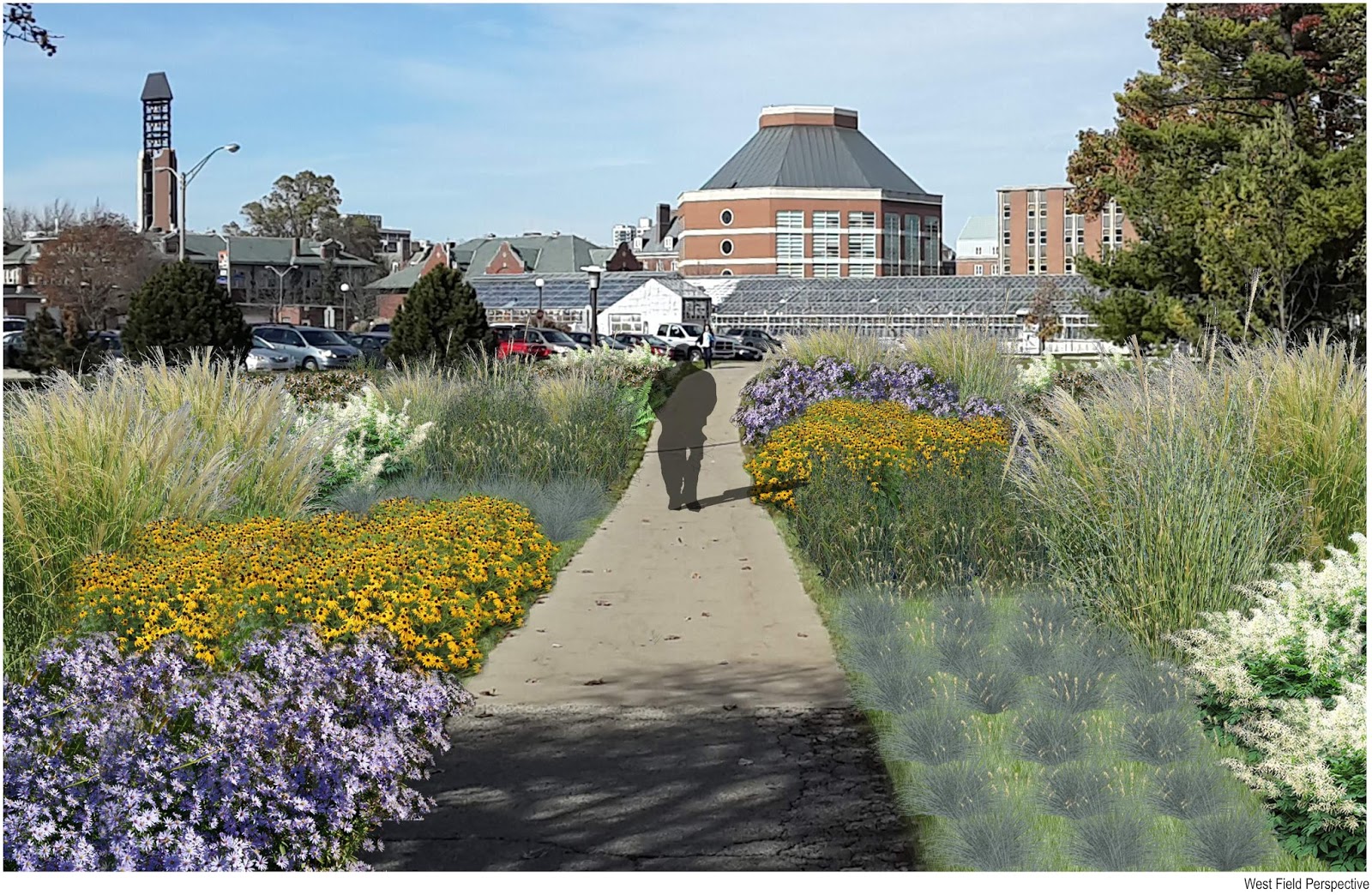
When you were a university student, did you ever reimagine your campus landscape? Students at the University of Illinois did exactly that as an assignment for Landscape Architecture (LA) 452, Native Plants and Design.
The U of I campus has 84 miles of storm sewer, most of which drain rainwater directly to Boneyard Creek. The LA 452 students designed landscapes with elements that capture water and allow it to soak in on-site to reduce loads to the existing storm sewer and creek. These elements (called green infrastructure) include rain gardens, swales, and green roofs. The Environmental Protection Agency (EPA) sees green infrastructure as a way to create sustainable, resilient communities that improve water quality.
EPA has a competition called the Campus RainWorks Challenge that invites “student teams to design an innovative green infrastructure project for their campus showing how managing stormwater at its source can benefit the campus community and the environment.”
According to Jason Berner, EPA environmental protection specialist, who has been involved with administering the competition, it is a great way for students to see how green infrastructure is related to the larger campus master plan. “It moves us beyond single pilot projects, but at the same time, blends both small and large scale thinking,” he explained.
LA 452 instructor Tawab Hlimi is leading the U of I Campus RainWorks entry. Students in his class helped brainstorm ideas for the entry. One of those ideas is pictured. Student Jiwon
Kim reimagined the grounds at the National Soybean Research Building (which happens to house Illinois-Indiana Sea Grant and the Illinois Water Resources Center). Native plant rain gardens intercept stormwater from the building roof and parking lot. During large storms, the design takes advantage of existing storm sewers by overflowing excess water to them.
Like many cities and universities, the U of I began installing storm sewers more than 100 years ago. Storm sewers benefit cities by draining flooded areas. However, they can overload receiving streams and cause unintended damage. Adding green infrastructure elements to the existing infrastructure helps ensure a healthier ecosystem on-site and downstream.
Per Hlimi, “Through a campus wide application of rain gardens, students hybridized native plantings with a superficial stormwater management strategy to meet multiple objectives: accommodating the ‘first flush’ of frequent storm events through detention, infiltration, and biofiltration, reducing the load on existing subsurface infrastructure, improving the water quality entering into the Boneyard Creek, creating habitat for pollinators, and rendering the campus landscape as living laboratory.”
Perhaps one day in the not too distant future, students won’t have to imagine green infrastructure on campus. They’ll see it.
Anjanette Riley was at last week’s Resilient Chicago workshop on climate trends and adaptive planning. She had this to say about the event:
Presentation after presentation, what struck me most is just how much climate change already is and will continue to impact our daily lives—and how interconnected those impacts are. Actually, a quick glance at the agenda was all it took to realize this workshop was going to be about much more than just predictions of yearly rainfall or average temperatures. The speakers were climatologists, public health experts, community planners, and policy specialists. And the participants were just as diverse—educators, urban planners, local officials, and private consultants.
Of course, we did talk about climate concepts and trends. IISG’s Molly Woloszyn kicked things off by making sure we were all on the same page about the difference between weather and climate—short-term changes vs. long-term averages. And throughout the day, Illinois State Climatologist Jim Angel told us that temperatures have risen by roughly 1.5o F over the last century and that we can expect drier summers and more precipitation in winter, spring, and fall.
Much of the day, though, was dedicated to what these changes mean for the people and wildlife that call the Chicago area home. Some impacts are pretty straightforward—you have likely seen them already. Warmer temperatures mean greater strain on an aging energy infrastructure and higher rates of heatstroke. Wetter springs means more stormwater runoff and basement flooding. And summertime droughts could lower crop yields and increase food prices.
Many were hard to see at first glance. As nice as they sound to many of us, warmer winters could have serious repercussions for public health, infrastructure, and Great Lake ecosystems. For example, with less frequent deep freezes, some disease-carrying insects could persist throughout the year. Fluctuations between freezing and thawing will also create more potholes and cracks in building exteriors. And—most unexpected to me—warmer water temperatures could make Lake Michigan and surrounding waterways more welcoming to a whole new suite of invasive species that could never have lived there before.
Fortunately, presenters came armed with solutions as well. Most were adaptation strategies—steps to prepare for climate change impacts. Speakers from Chicago Wilderness, the Alliance for the Great Lakes, and Hey and Associates, for example, showed how planting native trees, building rain gardens, and restoring natural areas could simultaneously filter pollutants from stormwater, lower air temperatures, and reconnect habitats divided by urbanization. Samuel Dorevitch, a professor at the University of Illinois at Chicago, and Dan Gabel from ComEd talked about the importance of early warning systems and emergency response plans. And the Center for Neighborhood Technology’s Harriet Festing introduced their Rain Readyprogram, which helps homeowners and communities understand flooding causes and prepare for future storms.
But don’t just take my word for it. All the presentations will soon be available on the Resilient Chicago website. In the meantime, peruse the many Midwestern Regional Climate Center resources on climate change predictions and adaptation planning.
For land use planners, balancing community growth and environmental health is always a challenge. But after months of pilot testing, IISG is putting the final touches on a new web-based tool that will help them do just that.
The Tipping Points and Indicators tool uses the latest watershed research and cutting-edge technology to show planners where aquatic ecosystems in their area are in danger of crossing a “tipping point,” triggering rapid and sometimes irreversible shifts in how they function. With help from a Sea Grant facilitator, planners can use the tool’s interactive maps, simulators, and recommended response strategies to develop watershed-specific plans that prevent ecosystems from being degraded beyond repair.
Specialists from Ohio, New York, Minnesota, Wisconsin, Michigan and Illinois-Indiana Sea Grant programs have spent the last few months testing the tool in broad range of communities and divers audiences. Planning groups from the industrialized southern Lake Michigan to the more preserved northern Wisconsin and Minnesota can now use the decision support system to kick off the watershed planning process. In Indiana, Ohio, and New York, facilitators have also introduced planning consultants and state employees to toolmodulesso they can take the process back to their own communities.
Experiences so far have been positive, with many users expressing excitement about the role Tipping Points and Indicators could play in improving watershed planning. Community members, local officials, and consultants were particularly interested in the tools’ recommended policies, ordinances, and outreach efforts tailored to local needs. In fact, a watershed advocacy group from the Duluth area mentioned they could have spent a whole day on that module alone.
To further enhance the tool, users also recommended making maps and planning strategies more watershed-specific. Many of these refinements are being made now. Others, including the addition of the new land cover data and models that predict future tipping points, are expected in the coming months.
And as the project grows, so does the lead team. Last month, IISG brought Purdue software developer Brandon Beatty onboard to help boost the usability of Tipping Points and Indicators and ensure it continues to rely on the latest research and technology.
The tipping points tool is part of a four-year project funded by NOAA and EPA and coordinated by Illinois-Indiana Sea Grant. Partners include Purdue University, University of Michigan, Michigan State University, University of Minnesota Duluth, University of Windsor, Great Lakes Environmental Research Laboratory, the Cooperative Institute for Limnology and Ecosystem Research, the Great Lakes Restoration Initiative, and the Sea Grant Great Lakes Network.
Located in Washington, D.C., the Sea Grant Knauss Fellowship provides a unique educational and professional experience to graduate students who have an interest in ocean, coastal and Great Lakes resources, and in the national policy decisions affecting those resources. This is a one-year fellowship open to any student, regardless of citizenship, who is enrolled toward a degree in a graduate or professional program on the day of the deadline.
Students enrolled at an Illinois or Indiana university or college should submit their applications through Illinois-Indiana Sea Grant by emailing Angela Archer at amcbride@purdue.edu. Students in surrounding states without a Sea Grant program should contact the National Sea Grant College Program at oar.sg.fellows@noaa.gov for a referral.
Application deadline: June 3, 2026.
To learn more about the fellowship, visit the link in bio.
Illinois-Indiana Sea Grant has five educator workshops lined up for spring and summer 2026, covering birds, watersheds, coastal science, earth systems, and engineering design.
🐦 May 3 · 💧 June 10 · 🌊 July 16 · 🌍 July 31–Aug 1 · 🏗️ Aug 18
Real-world connections. Field experiences. Takeaways your students will actually feel.
We brought the Great Lakes to @c2e2 in Chicago, and thousands of visitors discovered that food webs, invasive species, and aquaponics can be just as wild as surviving an alien ocean.
(Yes, we used Subnautica as a gateway to Great Lakes science. Yes, it worked.)
What topic do you think got people the most excited?
Invasive crayfish are reshaping freshwater ecosystems, and there`s a lot of new ground to cover. 🦞
The Invasive Crayfish Collaborative is hosting two virtual lightning talk sessions packed with the latest on impacts, distribution, management, and policy.
💻 Session 1: Mon, April 27 | 3 pm ET / 2 pm CT 💻 Session 2: Tue, April 28 | 12 pm ET / 11 am CT

.jpg)

