May 2nd, 2017 by IISG
St. Elmo Brady STEM Academy welcomed two IISG specialists to their roster of teachers recently.
Climate Specialist Molly Woloszyn and Education Coordinator Terri Hallesy carried on in the spirit of the academy by sharing their expertise with underrepresented fourth- and fifth-grade students in the Champaign, Illinois area.
The program was developed in 2013 by Ricky Greer, a K-12 education specialist, and Dr. Jerrod A. Henderson, a University of Illinois lecturer in Chemical and Biomolecular Engineering (CHBE). Its name, St. Elmo Brady, honors the first African-American student to earn a PhD in chemistry in the United States in 1916. Although the program is housed in CHBE, it’s meant to introduce students to a range of STEM disciplines.
Woloszyn and the students toured the weather station with Jim Angel, the Illinois state climatologist. She also did an activity that demonstrated air pressure – the collapsing can. She then taught them how to make a rain gauge from a 2-liter bottle that they could take home.
“I had a really great time doing this event,” Woloszyn said. “It was really fun to interact with the students and see them be so interested in making the rain gauge.”
Hallesy spent her time with the students talking about the role aquatic invasive species play in altering the Great Lakes basin ecosystem. She used fun games like “Stop Asian Carp in their Tracks” and “Nab the Aquatic Invader,” to explain how students by making simple changes, like properly disposing of a pet fish, can do their part in helping to prevent the spread of AIS.
“I see them as agents for change in their community. The kids were so interested in learning about what they could do to help,” Hallesy said. “They loved it!”
Program director Joe Gamez has seen the positive impact the program has had on the students.
“Without this exposure, minorities and girls think, ‘Oh, this this is not for me. This is for other people. Other people do that kind of stuff,’” Gamez said.
“But when they get exposure to it, it changes the way they look at things. The exposure the children get to these STEM topics from people who are so knowledgeable and passionate has really made a difference.”
December 15th, 2015 by iisg_superadmin
Flooding is always hard on a community, but when hospitals, mass transit, utilities, and others that impact the health and safety of residents are under water, these facilities may not be able to provide critical services or may even be forced to shut down. This leaves residents and businesses vulnerable to other threats and makes flood recovery ever more challenging.
The heart of the project is the Flood Vulnerability Assessment for Critical Facilities, which is an assessment tool. This set of questions will help Cook County managers determine a facility’s risk based on factors like its proximity to a flood plain, past flooding issues, stormwater drainage systems, and the location of key systems like back-up generators and computer servers. Facilities may also be able to use the tool to evaluate current emergency communication plans for heavy rainfall and determine whether improvements are necessary. After a pilot phase, the final assessment tool will be made available online for facilities beyond Cook County.
What’s more, to help managers plan with an eye on the future, the project team will use historic rainfall data and climate forecasts to pinpoint the frequency of heavy storms now and predict how that rate may change as the climate does. The Reducing Flooding Vulnerability of Chicago Critical Facilities project is led by Molly Woloszyn, IISG and MRCC extension climate specialist, and Beth Hall, MRCC director, with additional support from the
Coordinated Hazard Assessment and Mapping Program at the Illinois StateWater Survey. Funding is provided through the National Sea Grant Office as part of the Community Climate Adaptation Initiative, which is focused on helping communities prepare for climate change.
This story appears in the latest edition of The Helm.
December 4th, 2014 by iisg_superadmin
With that nip in the air and the occasional snow flurries, it’s hard to deny that winter is almost here. Will this year be as cold as last? Molly Woloszyn tackles this complicated question.

After a mild start to fall, November abruptly turned cold in the Midwest, giving us an early dose of winter. One of the coldest days was November 17th, when maximum daily temperatures of less than 30°F were widespread across the region—parts of southern Minnesota and northern Iowa only reached the single digits. With a preliminary average temperature of 31.4°F, November 2014 is now the Midwest’s sixth coldest November since records began in 1895.
But things are shaping up to be a little different for December. In fact, NOAA’s Climate Prediction Center (CPC) is now predicting a pattern change for at least the next two weeks. This means there’s a good chance that a majority of the United States will experience much milder conditions, with above-normal temperatures expected through the middle of the month. This isn’t necessarily surprising. We have a couple of examples in the past where record cold Novembers gave way to normal or warmer winters.
So, the question on all of our minds is “What does the rest of the 2014-2015 winter have in store for us Midwesterners?”
I wish I had a formula to tell you exactly what to expect. Accurate seasonal outlooks are always difficult to provide. But predictions are especially difficult this year because there is no strong signal or driver in the atmosphere.
What do I mean by “signal” or “driver”? I am talking about phenomenon like El Niño, which is the existence of unusually warm sea surface temperatures in the equatorial Pacific Ocean. Believe it or not, this can have major implications across the country. In the Midwest, winters tend to be warmer than normal—and drier in some places—when there is a strong El Niño. There is a 65 percent chance El Niño could develop this winter. However, if it emerges, it is likely to be weak, making it an undependable driver when it comes to this winter’s outlook.
 A few seasonal outlook approaches are pointing to the possibility for a colder-than-normal winter in the Midwest. For instance, some research suggests that there is a strong correlation between rapid snow advancement and its overall extent across Siberia and Eurasia during October and colder-than-normal winter temperatures and more snowfall in the eastern United States. In October 2014, snow cover advance and extent across Eurasia was the 2nd highest in the satellite era, suggesting it could be a cold and snowy winter here in the Midwest.
This prediction is supported by another phenomenon we are seeing in the central and northern Pacific Ocean. A positive Pacific Decadal Oscillation (PDO), which represents a warmer-than-normal pattern of sea surface temperatures, tends to encourage colder conditions in the eastern US. The PDO has been predominantly negative since the late 1990s, but it shifted to positive in 2014.
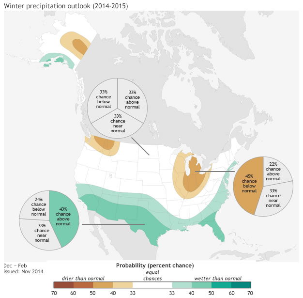
Even if a colder winter is in our future, it may not necessarily be a white one. NOAA’s CPC is predicting greater chances of below-normal precipitation in portions of the eastern Midwest, which is also related to the possibility for weak El Niño development. There is no clear signal for the rest of the region.
Of course, we will have more information on winter weather predictions as they come in. In the meantime, enjoy the more mild temperatures most likely in store for the next few weeks.
***Special thanks to the Chicago National Weather Service for providing some of this information, which came from their winter 2014-15 outlook.
Photo A: 24-hour maximum temperatures ending the morning of Nov. 18. 2014.
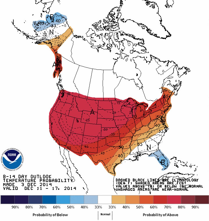
Photo B: The outlook for Dec. 10-16 from the Climate Prediction Center. Red shading represents areas with greater chances for above-normal temperatures.
Photo C: Winter temperature outlook for Dec. 2014 – Feb. 2015. Map by NOAAclimate.gov based on data from the Climate Prediction Center.
Photo D: Winter precipitation outlook for Dec. 2014 – Feb. 2015. Map by NOAAclimate.gov based on data from the Climate Prediction Center.
October 9th, 2014 by iisg_superadmin
 Anjanette Riley was at last week’s Resilient Chicago workshop on climate trends and adaptive planning. She had this to say about the event:
Presentation after presentation, what struck me most is just how much climate change already is and will continue to impact our daily lives—and how interconnected those impacts are. Actually, a quick glance at the agenda was all it took to realize this workshop was going to be about much more than just predictions of yearly rainfall or average temperatures. The speakers were climatologists, public health experts, community planners, and policy specialists. And the participants were just as diverse—educators, urban planners, local officials, and private consultants.
Of course, we did talk about climate concepts and trends. IISG’s Molly Woloszyn kicked things off by making sure we were all on the same page about the difference between weather and climate—short-term changes vs. long-term averages. And throughout the day, Illinois State Climatologist Jim Angel told us that temperatures have risen by roughly 1.5o F over the last century and that we can expect drier summers and more precipitation in winter, spring, and fall.
Much of the day, though, was dedicated to what these changes mean for the people and wildlife that call the Chicago area home. Some impacts are pretty straightforward—you have likely seen them already. Warmer temperatures mean greater strain on an aging energy infrastructure and higher rates of heatstroke. Wetter springs means more stormwater runoff and basement flooding. And summertime droughts could lower crop yields and increase food prices.
Many were hard to see at first glance. As nice as they sound to many of us, warmer winters could have serious repercussions for public health, infrastructure, and Great Lake ecosystems. For example, with less frequent deep freezes, some disease-carrying insects could persist throughout the year. Fluctuations between freezing and thawing will also create more potholes and cracks in building exteriors. And—most unexpected to me—warmer water temperatures could make Lake Michigan and surrounding waterways more welcoming to a whole new suite of invasive species that could never have lived there before.

Fortunately, presenters came armed with solutions as well. Most were adaptation strategies—steps to prepare for climate change impacts. Speakers from Chicago Wilderness, the Alliance for the Great Lakes, and Hey and Associates, for example, showed how planting native trees, building rain gardens, and restoring natural areas could simultaneously filter pollutants from stormwater, lower air temperatures, and reconnect habitats divided by urbanization. Samuel Dorevitch, a professor at the University of Illinois at Chicago, and Dan Gabel from ComEd talked about the importance of early warning systems and emergency response plans. And the Center for Neighborhood Technology’s Harriet Festing introduced their Rain Readyprogram, which helps homeowners and communities understand flooding causes and prepare for future storms.
But don’t just take my word for it. All the presentations will soon be available on the Resilient Chicago website. In the meantime, peruse the many Midwestern Regional Climate Center resources on climate change predictions and adaptation planning.
July 31st, 2014 by iisg_superadmin
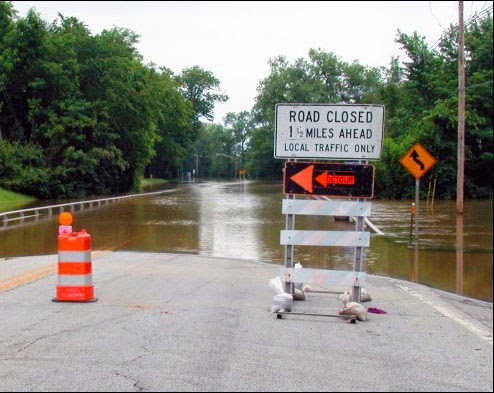
In July, the Taste of Chicago closed down for a day due to heavy rain. In the suburbs, storms are flooding streets and basements. It’s a rainy year—the month of June had the third highest rainfall at Chicago O’Hare since records have been kept in 1959.
City sewers built to take on storms from days gone by are no match for today’s rainfall that lands mostly on parking lots, streets, and sidewalks instead of being absorbed into fields and patches of forest. What’s more, climate change predictions appear to be coming true—larger storms are hitting more frequently.
Basements and streets underwater are a serious concern, but when Superstorm Sandy hit the east coast two years ago, it illustrated that flooding of critical facilities, such as hospitals, can have widespread and possibly catastrophic impacts.
IISG’s climate specialist, Molly Woloszyn, is tackling the issue of flooding from the angle of better preparation and prediction. She is part of a project that is assessing the flooding vulnerability of critical buildings in Chicago, including utility providers, transportation facilities, and hospitals. She is looking at factors like location, elevation, and flooding history of the facility, but also the placement of critical systems, such as generators and potable water supplies. Ultimately, this will result in recommendations on how these facilities can shore up their structures and systems to reduce this risk in the face of future storms.
Molly and other project contributors at the Midwestern Regional Climate Center are also dipping into 25 years of data from the Cook County Precipitation Network to connect large rain events with their consequences, such as combined sewer overflows and reports of basement and viaduct flooding. The goal here is to help the National Weather Service make forecasts that are impact-based for the city of Chicago.
Updating rain event reports for what constitutes a 5-year storm or a 100-year storm, for example, (meaning the probability of these storms happening is 1 in 5 or 1 in 100 years) is one part of the city’s plan for getting ahead of flooding concerns as detailed in the City of Chicago Green Stormwater Infrastructure Strategy. Planners and engineers use long term rainfall data to make decisions going forward, but the last report was released in 1992 with data up to the mid-80s. By all accounts, big storms are getting bigger and more frequent. More data is key for local decision makers. The Midwestern Regional Climate Center’s analysis of the Cook County data will provide new rainfall thresholds for various sized events over the course of the last 25 years.
July 18th, 2014 by iisg_superadmin
It probably comes as no surprise to those living in the Great Lakes region to hear that this spring was one of the coldest on record. Since 1948, there have been only four years with lower spring temperatures. And these unusually cold temperatures—and the snow that came with them—had significant impacts on Great Lakes ecosystems, communities, and economies.
These impacts are the focus of the latest edition of the Great Lakes Quarterly Climate Impacts and Outlook report. Released in June, the report details how the long winter helped lake levels rebound from record lows, forced cities to invest more in winter operational expenses and infrastructure maintenance, and has left some farmers concerned about this year’s crop. It also provides a look at expected temperatures and precipitation levels for the coming months.
The Great Lakes Quarterly Climate Impacts and Outlooks is developed by NOAA and Environment Canada. Past editions, as well as reports for other regions, are available at the U.S. Drought Portal.
June 12th, 2014 by iisg_superadmin
Summer and winter may look a little different this year. The National Weather Service Climate Prediction Center is reporting warmer temperatures in the Pacific Ocean along the equator, which could mean big things in the Midwest and around the world.
The global weather phenomenon is known as El Nino. It occurs every few years when a giant band of water in the tropical Pacific Ocean becomes unusually warm. This sets off a chain reaction of weather events that have historically resulted in severe droughts in portions of India, Southeast Asia, Australia, and South America. In contrast, El Nino often brings heavy rains to the West Coast.
The effects are a little milder in the Midwest, which is likely to see cooler summers and winters with less snowfall. Some parts of the region might even have better corn and soybean yields thanks to the milder temperatures.
El Nino events are difficult to predict, and there is no guarantee we will experience one this year. A recent advisory from the Climate Prediction Center, though, puts the chance of El Nino as high as 80 percent.
Keep an eye on the developing El Nino with weekly updates from the National Weather Service. And for more information on climate trends and changes in the Midwest, visit the Midwestern Regional Climate Center.
*Photo courtesy of the National Weather Service.
.jpg)


