As you dine on locally-caught fish, you probably aren’t thinking of that old acrylic sweater or fleece jacket that you wear and wash frequently. But it turns out that they may be on your plate. Illinois-Indiana Sea Grant-funded researchers have found microplastic fibers that come from clothing and other sources in the water, in sediment and in fish in three major rivers that flow into Lake Michigan.
Loyola University Chicago biologists John Kelly, Tim Hoellein and Rachel McNeish are assessing levels of microplastic using a range of measures. As part of a larger study, they collected samples from the mouths of the Muskegon, Milwaukee and St. Joseph rivers seasonally over the course of 2016 and into 2017.
“We found that 99 percent of the microplastic is fibers, and microfibers are everywhere,” said McNeish, a post doc who implemented the project. “Much of what we found is acrylic, polyester, and polyethylene, which comes from plastic bags.” These plastics break down to microscopic size in the water due to physical abrasion, sunlight and freezing.
While water sampling is typically done using nets, the Loyola team also sampled water directly. “We started doing these grab samples, we just fill up a liter container and bring it back and filter it, and we found particles smaller than 300 microns, the pore size of the nets,” said Kelly. “The smaller you go, the more numerous the pieces of plastic there are.”
The three rivers in this study have provided insight into the effect of how we use the land on how much microplastic is in the environment, which was a key goal of this project.
The most northern river, the Muskegon, which flows through land dominated by forests had less microplastic than the other two rivers, as one might expect. Moving south to more populated and developed areas, are the St. Joseph River, in a farm-rich watershed, and the Milwaukee River, which sits in a mixed, urban and agricultural region. The researchers found that both agriculture and urban land uses contribute significantly to the abundance of microplastic in these Lake Michigan tributaries.
“Ultimately what we really want to do is predict what aspects of our development or features of the landscape pose bigger problems when it comes to contributing microplastic to the landscape,” said Hoellein. “And we need to understand where microplastic accumulates the most, because if we don’t answer those questions, we’re not really in a good position to come up with a solution or even address the problem.”
The researchers also sampled 74 fish from the shallow waters of these three rivers and 85 percent of them, including bass and other sportfish, contained microplastic in their digestive tract, averaging 13 particles. They found that the amount of microplastic in individual fish was not a reflection of how much plastic was in the water—fish from all three sites had similar numbers of microfiber in their digestive system.
How much microplastic shows up in one fish versus another can better be explained by looking at the food web. The researchers found that fish that eat insects and other invertebrates, which may already contain microplastic, have more fibers than those that eat plants.
“Microplastic is interacting with aquatic wildlife,” said McNeish. “Fish are consuming it—either actively eating it thinking its food, eating insects with microplastic in them or maybe just drinking water with microplastic. Or they may consume it through contact with sediment. In any case, microplastic is entering the food web.”
“And as these three rivers drain into Lake Michigan,” she explained, “the movement of microplastic can happen with the rivers’ currents, but also through the migration of animals.”
Milwaukee residents who have spent most of their lives near the sprawling Lincoln Park have stories to tell about how degraded the park had become. The Milwaukee River was hidden behind buckthorn and other brush and the fish that lived in the tainted water were too contaminated to eat.
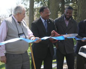
Last week they shared some of these memories as part of a joyous celebration that the park and river have been cleaned up. State Representative Mandela Barnes described the park now as “good for people’s health.” At this event, a ceremonial ribbon was cut and the park was officially reborn.

Lincoln Park is in the Milwaukee Estuary Area of Concern, designated by the International Joint Commission. Contamination in the park came from historic industrial and municipal discharges among other sources.
The cleanup of Lincoln Park got its biggest boost from the Great Lakes Legacy Act, which provided federal matching funds from the U.S. Environmental Protection Agency to share the project’s cost with Wisconsin Department of Natural Resources (DNR) and Milwaukee County Parks. Agency representatives, as well as local officials and residents, were on site to celebrate this success story.

Over a four year period, 171,000 cubic yards of sediment laced with an alphabet soup of contaminants—PCBs, PAHs, and NAPLs—were removed from targeted zones in the river and 12.5 acres of shoreline were restored. Commenting the time and work that went into this remediation and restoration, Cameron Davis, EPA senior advisor to the administrator, described the project partners as more persistent than the contaminants themselves.
Throughout the process, Caitie Nigrelli, IISG environmental social scientist was on the ground, keeping the community informed, but also facilitating residents to take some ownership of the park. Nigrelli helped a volunteer organization get started—Friends of Lincoln Park—and joined in the group’s one year anniversary last fall.
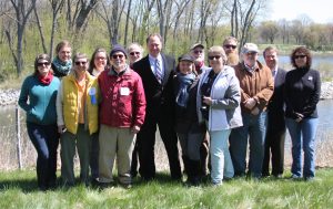
 Anne Stadler Vaillancourt, a leader of the Friends group, spoke at last week’s event and a number of members were there to set up, take down, and enjoy the festivities. The organization is enjoying success and is ready to grow in membership. They recently held a volunteer cleanup day at the park and more than 100 people showed up. They have two upcoming Weed Out events to remove invasive species on May 14 and May 28.
Stadler Vaillancourt expressed to the morning’s participants that the Friends of Lincoln Park are committed to take care of the park for the long term.
Also in attendance were: Kevin Haley, landscape architect and John Dargle, Jr., director, both of Milwaukee County Parks; State Sen. Lena Taylor; State Rep. David Brown; Theo Lipscomb, chairman of Milwaukee County Board of Supervisors; and Ed Eberle, assistant deputy secretary of Wisconsin DNR.
A group of urban planning graduate students from University of Illinois have just returned from Milwaukee—but this wasn’t your typical weekend excursion. They spent their time interviewing government employees, business owners, members of the community, and others affected by clean-up efforts on the Milwaukee Estuary, where industrial toxins threaten water quality and aquatic wildlife. And the information they collected will go a long way to ensuring that future restoration and remediation projects across the region leave nearby communities stronger than they were before.
 It is all a part of an IISG-funded project investigating the relationship between sediment removal projects and a community’s vulnerability to environmental hazards like natural disasters, pollution, and changing weather patterns. Social vulnerability depends on a lot of factors—average income, education levels, public engagement, and more. Using the Milwaukee Estuary and Grand Calumet Areas of Concern as models, U of I researchers Bethany Cutts and Andrew Greenlee are investigating how these factors change—for better or worse—when a community becomes involved in sediment removal projects.
This project stands apart from much of the research on community vulnerability. It is localized, focused on vulnerability over time, and supplements census data with qualitative information on community attitudes and perceptions of remediation. Because of these differences, its results will be a significant boost to the tool government agencies currently use to determine and reduce social vulnerability, the Social Vulnerability Index. Cutts and Greenlee are calling their tool the Social Vulnerability Index Plus (SoVI+).
When it is done, SoVI+ will help groups involved in remediation, including IISG, better prepare communities for the aspects of cleanup that may increase vulnerability—like restricted road access and heavy truck traffic. EPA could also use the new tool to prioritize sediment remediation in areas where it will be most beneficial.
 Work is just beginning, but the project promises a lot of data collection and analysis over the next few years. That is where the students come in. They are all part of the Workshop in Urban Environmental Equity, an inter-departmental course focused on identifying historical demographic changes in the researched regions, as well as developing and piloting interview strategies that Cutts and Greenlee will continue to use well after the course is complete. Beyond being a big step forward for the research project, the workshop provides a unique opportunity for students to be a part of the design and implementation of a multidisciplinary, mixed-method research project—what one student called “the holy grail” of research. Situated at the intersection of social and economic shifts, environmental restoration, planning, and policy, the course and the research can have tremendous benefits for ongoing and future remediation projects and the coastal communities.
Photo A: Natalie Prochaska, Juliana Wilhoit, Andrew Greenlee, Annie Contractor, Vinisha Doshi, Nancy Smebak, and Rachel Wilson take a break from their work in Milwaukee. (Not pictured: urban planning graduate student and workshop member Carolina Chantrille.)
Photo B: U of I students take part in a “Ski the AOC” event to learn more about ongoing remediation efforts and the community.


 Anne Stadler Vaillancourt, a leader of the Friends group, spoke at last week’s event and a number of members were there to set up, take down, and enjoy the festivities. The organization is enjoying success and is ready to grow in membership. They recently held a volunteer cleanup day at the park and more than 100 people showed up. They have two upcoming Weed Out events to remove invasive species on May 14 and May 28.

