November 11th, 2014 by iisg_superadmin
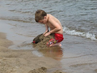 If you’re a regular visitor to Great Lakes beaches, you likely noticed that this year’s swim season was chillier than normal. Cold enough, in fact, that many chose to skip swimming in favor of other beach activities. And according to officials at the National Weather Service, this may explain the unusually low number of current-related fatalities and rescues this year.
From Michigan Sea Grant:
There were 6 fatalities and 12 rescues related to currents on the Great Lakes, which is below the 12-year average of 12 fatalities and 25 rescues per year.
As is typical, the majority of the 2014 incidents occurred along Lake Michigan. On average from 2002-2014, Lake Michigan had 25 incidents per year, while Lake Erie had 5 incidents per year, Lake Superior had 3 incidents and Huron and Ontario average 1 to 1.5 per year, respectively.
The data for 2014 has now been updated in the Great Lakes Current Incident Database, available at DangerousCurrents.org. The database was developed and is maintained by Michigan Sea Grant and National Weather Service (NWS). Megan Dodson, a NWS meteorologist, gathers the statistics for the database and provides yearly swim season assessments of conditions related to currents.
Dodson noted the cool weather influenced not just the below-average number of incidents, but where they happened too.
“A majority of the current-related incidents in 2014 occurred near river mouths, which is unusual when compared with past years,” she said. “The cooler air and water temperatures may have driven beachgoers to swim near river mouths and other outlets, where the water is much warmer. However, there are currents present that can be strong and vary depending on the flow of the outlet and the waves at the beach. While these currents are most dangerous during times of high waves, they can still be strong despite calmer lake conditions — as we saw during the 2014 swim season.” Read more
Swim season may be over, but it is never too early to start planning for next year. To stay safe in the water, be sure to:
- Steer clear of the pier — Nearly 60 percent of fatalities and rescues in the Great Lakes database occurred near breakwaters and piers. Structural currents are nearly always present near these barriers, even when waves are low. Breaking waves can also bounce off the structure, making swimming nearly impossible.
- Stay dry when waves are high — Nearly 85 percent of fatalities and rescues in the Great Lakes database happened when waves are 3-5 feet or greater. Unlike in the oceans, Great Lakes waves crash against the shoreline in rapid succession, making it difficult to swim. Additionally, strong rip currents are more likely when waves are above 3 feet. The combination of quickly approaching waves and strong currents create extremely dangerous conditions for swimmers.
- Don’t swim in the outlet — Water flowing from a river mouth or other outlet can push swimmers out into the lake. Nearly 40 percent of the 2014 incidents were outlet-current related.
July 18th, 2014 by iisg_superadmin
It probably comes as no surprise to those living in the Great Lakes region to hear that this spring was one of the coldest on record. Since 1948, there have been only four years with lower spring temperatures. And these unusually cold temperatures—and the snow that came with them—had significant impacts on Great Lakes ecosystems, communities, and economies.
These impacts are the focus of the latest edition of the Great Lakes Quarterly Climate Impacts and Outlook report. Released in June, the report details how the long winter helped lake levels rebound from record lows, forced cities to invest more in winter operational expenses and infrastructure maintenance, and has left some farmers concerned about this year’s crop. It also provides a look at expected temperatures and precipitation levels for the coming months.
The Great Lakes Quarterly Climate Impacts and Outlooks is developed by NOAA and Environment Canada. Past editions, as well as reports for other regions, are available at the U.S. Drought Portal.
June 16th, 2014 by iisg_superadmin
It’s beach season once again in southern Lake Michigan, and the rip current warnings have already begun.
The National Weather Service (NWS) has issued at least one advisory since Illinois and Indiana beaches opened last month asking beach-goers to think twice before taking a dip in the lake. And for good reason. Rip currents and other dangerous currents are the biggest threat to Great Lakes swimmers. Roughly 140 people have drowned in the lakes over the last 12 years due at least in part to dangerous currents. And most of those incidents happened in Lake Michigan.
Illinois-Indiana Sea Grant hopes to bring these numbers down with a new outreach effort that will raise awareness about dangerous currents in the Great Lakes. The “Implementing Dangerous Currents Best Practices” project was recently awarded funding from the NOAA Coastal Storms Program.
A collaborative effort Sea Grant programs in Michigan and Wisconsin, the project will include print and online resources—including educational videos—that introduce the science behind rip currents, provide tips for avoiding them, and explain what to do if you or others are caught in one. Many of these resources will be available in both English and Spanish.
Watch for further information on these outreach efforts and rip currents in the coming months. In the meantime, you can find tips for staying safe at the beach this summer at dangerouscurrents.org.
“Implementing Dangerous Currents Best Practices” continues years of efforts by Great Lakes Sea Grant programs, NOAA, and NWS to reduce dangerous currents drownings across the region. To learn more about these efforts, visit Rip Current Safety.
June 12th, 2014 by iisg_superadmin
Summer and winter may look a little different this year. The National Weather Service Climate Prediction Center is reporting warmer temperatures in the Pacific Ocean along the equator, which could mean big things in the Midwest and around the world.
The global weather phenomenon is known as El Nino. It occurs every few years when a giant band of water in the tropical Pacific Ocean becomes unusually warm. This sets off a chain reaction of weather events that have historically resulted in severe droughts in portions of India, Southeast Asia, Australia, and South America. In contrast, El Nino often brings heavy rains to the West Coast.
The effects are a little milder in the Midwest, which is likely to see cooler summers and winters with less snowfall. Some parts of the region might even have better corn and soybean yields thanks to the milder temperatures.
El Nino events are difficult to predict, and there is no guarantee we will experience one this year. A recent advisory from the Climate Prediction Center, though, puts the chance of El Nino as high as 80 percent.
Keep an eye on the developing El Nino with weekly updates from the National Weather Service. And for more information on climate trends and changes in the Midwest, visit the Midwestern Regional Climate Center.
*Photo courtesy of the National Weather Service.
May 14th, 2014 by iisg_superadmin
The National Weather Service’s Weather-Ready Nation initiative was begun to help communities throughout the country better prepare for and respond to severe weather events. Much of that preparedness has to do with increasing the speed, accuracy, and effectiveness of weather monitoring and warning mechanisms on the local level. And finding the strongest ways to communicate weather messages to residents is key.
That is why, as part of the Weather-Ready Nation project, the Great Lakes Social Science Network conducted extensive research into the most effective impact-based warnings. Their report, “Evaluation of the National Weather Service Impact-based Warning Tool,” utilized interviews, focus groups, and surveys to determine the most and least effective ways for broadcast meteorologists and emergency managers to communicate these warnings to the public.
National Weather Service piloted an impact-based warning system in 2012 in five select offices, and expanded it to the central region’s 38 offices in 2013. The report offers a sort of mid-term evaluation of the system’s effectiveness and stakeholders’ perceptions of it, while also providing recommendations for further training and implementation improvements.
This research was a team effort between representatives from five Great Lakes Sea Grant programs. Caitie McCoy and Leslie Dorworth from Illinois-Indiana Sea Grant were involved, as well as Dr. Jane Harrison (Wisconsin Sea Grant), Dr. Kathy Bunting-Howarth (New York Sea Grant), Hilarie Sorensen (Minnesota Sea Grant), Katie Williams (University of Wisconsin-Milwaukee), and Dr. Chris Ellis (NOAA Coastal Services Center). The report was presented earlier this year to the Social Coast Forum in Charleston, SC, sparking a number of other groups and agencies to inquire about the report and possible opportunities to expand on it with further research.
For further information about the Great Lakes Social Science Network, as well as training and future research projects, visit the link above.
April 2nd, 2014 by iisg_superadmin
While the spring thaw will be a welcome change of weather in most of the country, there is a risk that snow melt and spring rains could lead to rivers exceeding flood levels.
“The continuation of winter weather, above-average snowpack, frozen ground and thick ice coverage on streams and rivers will delay spring flooding into April in the upper Midwest eastward to New England.
The intensity of the flooding will depend on the rate of snow and ice melt, and future rainfall.
Continued well-below average temperatures this winter resulted in significant river ice formation and ice jams in locations further south than customary, flooding homes and businesses, and impacting river commerce.
There is also an elevated risk of more ice jams this spring in the northern tier of the U.S. from Montana eastward to northern New England.
‘This year’s spring flood potential is widespread and includes rivers in highly populated areas putting millions of Americans at risk,’ said Louis Uccellini, director, NOAA’s National Weather Service.
‘Although widespread major river flooding is not expected, an abrupt warming or heavy rainfall event could lead to isolated major flooding.'”
Read the rest of the article at the link above.
June 4th, 2013 by Irene Miles
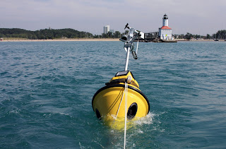
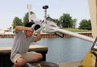 Swimmers, boaters, and anglers visiting Indiana’s coastline this summer will again be able to learn about conditions in Southern Lake Michigan thanks to real-time data collected by the Michigan City buoy. The buoy, launched for the first time last fall, returned to its post four miles from shore last week to collect data on wave height and direction, wind speed, and air and surface water temperatures. It will stay in the water until November.
The relaunch comes just in time to help make summer trips to Michigan City and the Indiana dunes safer. Throughout the season, scientists at the National Weather Service (NWS) in northern Indiana will use wave height and frequency data collected by the buoy to better anticipate likely locations of strong waves and rip currents that cause dangerous swimming conditions. The only one of its kind in the Indiana waters of the lake, the Michigan City buoy gives forecasters access to historically unavailable nearshore data where conditions are much different than at the center of the lake. Real-time data from the buoy has already helped NWS improve their wave height forecasts.
 “This information is vital for NWS forecasters to access and accurately forecast the potential for dangerous swimming and boating conditions along southern Lake Michigan,” said John Taylor, a meteorologist with the NWS office in northern Indiana. “Our hope is that by accurately forecasting when high waves and rip currents along the shoreline will result in dangerous swimming conditions, we can reduce the number of tragic drownings that occur in these waters every summer.”
The site lets visitors see real-time snapshots of lake conditions—updated every 10 minutes—as well as trends over 24-hour and 5-day periods.
And this year, the Michigan City buoy joins the ranks of environmental monitors that contribute to NOAA’s National Data Buoy Center. The addition makes it possible for people to easily access data older than five days and track trends over longer periods of time. This archived data is particularly important for researchers and natural resource managers who rely on the buoy’s data to improve weather forecasts, protect water quality, and predict where best to fish.
The buoy launch also coincides with Rip Current Awareness Week, and is just one piece of a larger effort to protect people from the dangers of rip currents. Visit the Rip Current Awareness Week website to learn more about rip currents and what you can do to protect yourself this summer.
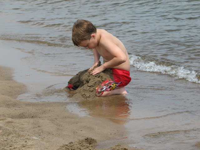 If you’re a regular visitor to Great Lakes beaches, you likely noticed that this year’s swim season was chillier than normal. Cold enough, in fact, that many chose to skip swimming in favor of other beach activities. And according to officials at the National Weather Service, this may explain the unusually low number of current-related fatalities and rescues this year.


