December 11th, 2014 by iisg_superadmin
The two IISG-sponsored Knauss Fellows selected for 2015 recently returned from D.C., where they met with other fellows, interviewed with government agencies and offices, and learned where they will spend the next year working on water resource and environmental issues. Alyssa Hausman, a Master’s student at Indiana University, shares her experiences.
 Placement week was one of the most unique and exciting experiences that I have gone through, but I am so glad that I will never have to do it again. My week consisted of 15 interviews for 16 positions and concluded with my placement for the next year. In the process, I managed to meet 51 fantastic and brilliant people that I will get to share this next year and fellowship experience with. I also learned more about the various executive offices involved in marine policy than I thought possible in such a short time.
I was placed with the U.S. Fish and Wildlife Service Division of Congressional and Legislative Affairs. This coming year, I will serve as a liaison with the offices of congressional members and committees. Though the portfolio of issues I will be working on will not be determined until I start this position, the current fellow is assigned to issues regarding endangered species, coastal and marine resources, and fisheries. This position will expand my knowledge of natural resource management and the legislative process.
 I have had the opportunity to work with Knauss fellows in the past and admired their commitment to the stewardship of marine environments and the opportunities that the fellowship provided them. This past summer, for example, I interned with NOAA’s Office of National Marine Sanctuaries, where I realized just how extensive and strong the Knauss network is. The office has two current fellows and a handful of alumni, all of whom welcomed me into the “mafia” when I received my acceptance in June. Seeing how connected these alumni remain to the program and how supportive they are of incoming fellows makes me excited and proud to be a part of this network. These experiences collaborating with past fellows are what drove me to the Knauss fellowship, and I am honored that I will be joining their ranks in February.
In two short weeks, I will be graduating from Indiana University’s School of Public of Environmental Affairs with dual Master’s degrees in environmental science and public affairs. I am very much looking forward to beginning my fellowship and my post-graduate career—after a much needed month off, of course.
December 4th, 2014 by iisg_superadmin
With that nip in the air and the occasional snow flurries, it’s hard to deny that winter is almost here. Will this year be as cold as last? Molly Woloszyn tackles this complicated question.

After a mild start to fall, November abruptly turned cold in the Midwest, giving us an early dose of winter. One of the coldest days was November 17th, when maximum daily temperatures of less than 30°F were widespread across the region—parts of southern Minnesota and northern Iowa only reached the single digits. With a preliminary average temperature of 31.4°F, November 2014 is now the Midwest’s sixth coldest November since records began in 1895.
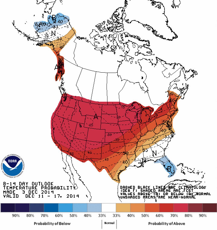
But things are shaping up to be a little different for December. In fact, NOAA’s Climate Prediction Center (CPC) is now predicting a pattern change for at least the next two weeks. This means there’s a good chance that a majority of the United States will experience much milder conditions, with above-normal temperatures expected through the middle of the month. This isn’t necessarily surprising. We have a couple of examples in the past where record cold Novembers gave way to normal or warmer winters.
So, the question on all of our minds is “What does the rest of the 2014-2015 winter have in store for us Midwesterners?”
I wish I had a formula to tell you exactly what to expect. Accurate seasonal outlooks are always difficult to provide. But predictions are especially difficult this year because there is no strong signal or driver in the atmosphere.
What do I mean by “signal” or “driver”? I am talking about phenomenon like El Niño, which is the existence of unusually warm sea surface temperatures in the equatorial Pacific Ocean. Believe it or not, this can have major implications across the country. In the Midwest, winters tend to be warmer than normal—and drier in some places—when there is a strong El Niño. There is a 65 percent chance El Niño could develop this winter. However, if it emerges, it is likely to be weak, making it an undependable driver when it comes to this winter’s outlook.
 A few seasonal outlook approaches are pointing to the possibility for a colder-than-normal winter in the Midwest. For instance, some research suggests that there is a strong correlation between rapid snow advancement and its overall extent across Siberia and Eurasia during October and colder-than-normal winter temperatures and more snowfall in the eastern United States. In October 2014, snow cover advance and extent across Eurasia was the 2nd highest in the satellite era, suggesting it could be a cold and snowy winter here in the Midwest.
This prediction is supported by another phenomenon we are seeing in the central and northern Pacific Ocean. A positive Pacific Decadal Oscillation (PDO), which represents a warmer-than-normal pattern of sea surface temperatures, tends to encourage colder conditions in the eastern US. The PDO has been predominantly negative since the late 1990s, but it shifted to positive in 2014.
Even if a colder winter is in our future, it may not necessarily be a white one. NOAA’s CPC is predicting greater chances of below-normal precipitation in portions of the eastern Midwest, which is also related to the possibility for weak El Niño development. There is no clear signal for the rest of the region.
Of course, we will have more information on winter weather predictions as they come in. In the meantime, enjoy the more mild temperatures most likely in store for the next few weeks.
***Special thanks to the Chicago National Weather Service for providing some of this information, which came from their winter 2014-15 outlook.
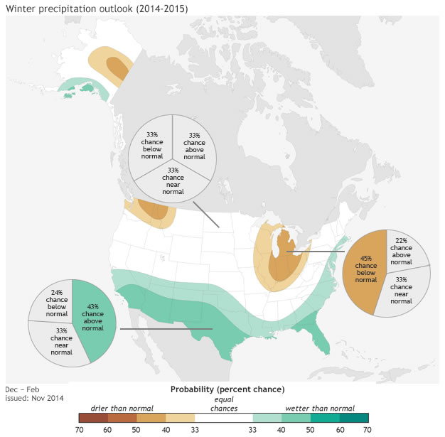
Photo A: 24-hour maximum temperatures ending the morning of Nov. 18. 2014.
Photo B: The outlook for Dec. 10-16 from the Climate Prediction Center. Red shading represents areas with greater chances for above-normal temperatures.
Photo C: Winter temperature outlook for Dec. 2014 – Feb. 2015. Map by NOAAclimate.gov based on data from the Climate Prediction Center.
Photo D: Winter precipitation outlook for Dec. 2014 – Feb. 2015. Map by NOAAclimate.gov based on data from the Climate Prediction Center.
August 12th, 2014 by iisg_superadmin
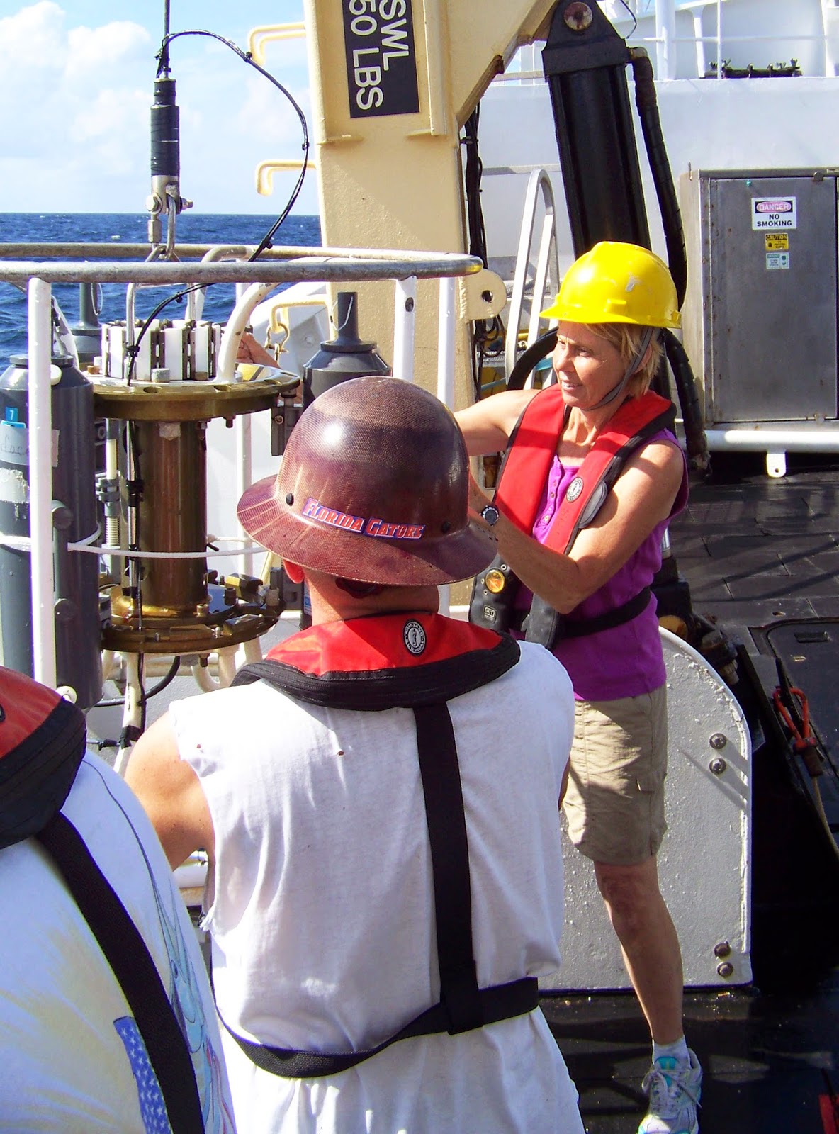
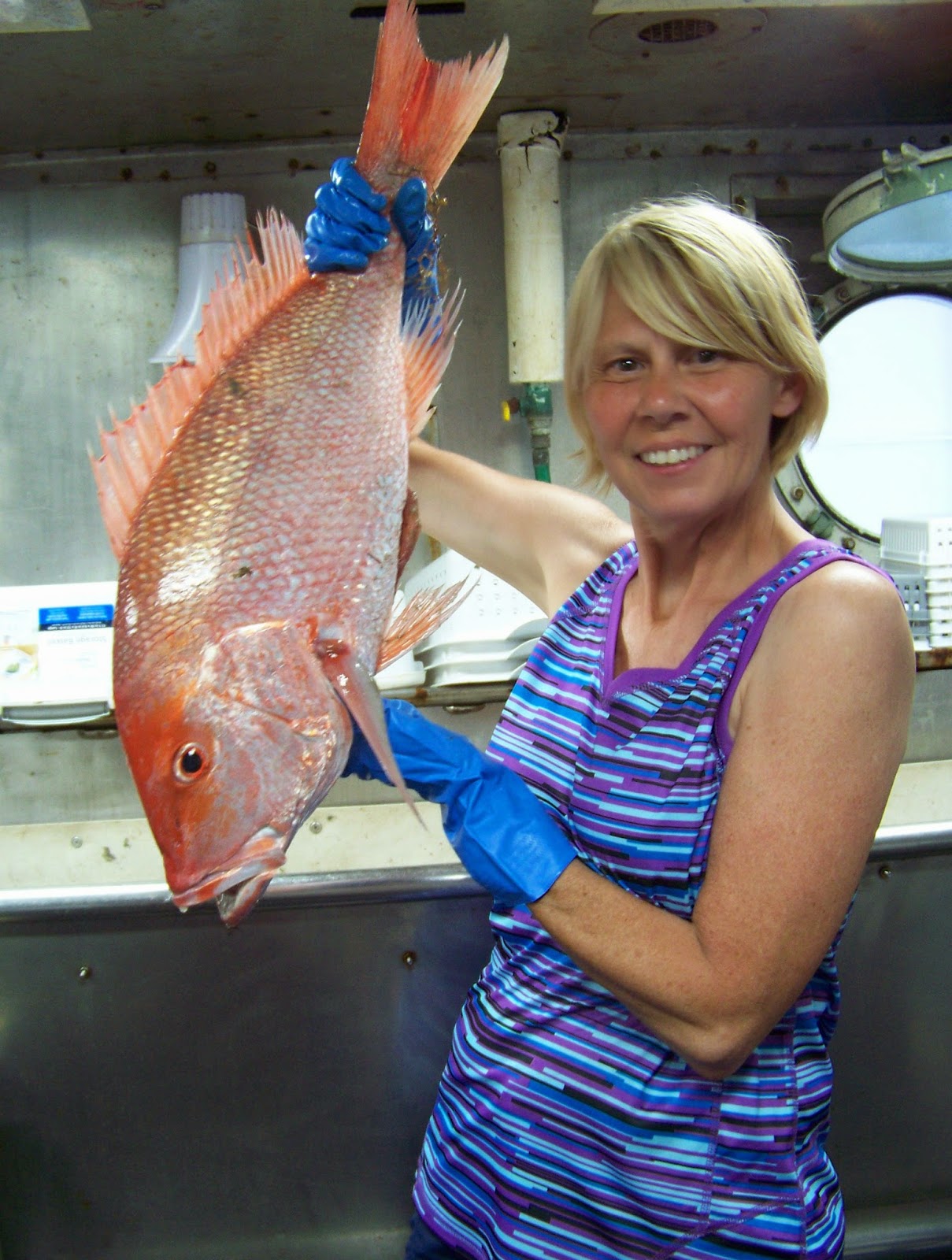
Illinois teacher Carol Schnaiter has big plans for her classes at Amboy Central School. Carol was one of 14 teachers to participate in IISG’s B-WET workshop last year. And this summer, she spent two weeks in the Gulf of Mexico aboard the NOAA research vessel Oregon II. Carol wrote in to tell us about her experiences at both, how they have already shaped her curriculum, and what she has planned for her students this year.
“I am constantly looking for workshops, classes, and events that I can attend and bring what I learned back to my class. Each adventure adds to our classroom and allows the students to learn something new.
 I was very excited when I was selected for the B-WET workshop in June of 2013. After the workshop, I added an entire unit on invasive species in the Great Lakes area for the 4th graders and another unit on restoration for the 3rd graders, plus I expanded the watershed unit I was teaching to the third graders. At the end of the units, I invited a guest speaker from the Amboy Marsh, Greg Hunter, to speak to all my classes about the Amboy Marsh and invasive species in our area. We then went to the Amboy Marsh, where the students pulled the invasive Garlic Mustard plant and cleaned away brush. The staff also arranged for guest speakers to talk about turtles, birds, and plants and gave a walking tour of the marsh. My colleagues and I are hoping to continue working with Amboy Marsh when we do our invasive species unit and our restoration unit each year.
 The students loved learning about the invasive species! We used the cards from the Sea Grant curricula and played games, such as Beat the Barriers. The students also did research on the various species and used the watch cards. When Mr. Hunter came in to speak, the students had background information on invasive species and were able to connect with what he was discussing.
This summer, I took part in the NOAA Teacher at Sea Program in the Gulf of Mexico. While on the ship, I worked with NOAA scientists and the crew to learn about the Gulf ecosystems first-hand and watch real science in action. I was on the midnight-to-noon shift for 16 days. We traveled to “stations” across the Gulf where we dropped the trawling net, the bongo nets, and the CTD (conductivity, temperature, and depth) sensors as part of the Groundfish Survey. Once the nets were brought up, we would count, measure, weigh, and record the sex of all the species. Our main objective was to collect information and send it to federal agencies that used it to set the shrimp season and catch limits.
 As a result of this experience, I am working on adding more information to our invasive species unit and creating another unit that will have the students trace the water from the Great Lakes watershed to the Gulf of Mexico. We will be following the NOAA Ship Oregon II as they go out for the fall Groundfish Survey and adding that information to the data collected while I was aboard this summer. We will be watching the water’s oxygen levels as the ship travels across the Gulf and will try to figure out what might be the cause of any changes.
Tying both the B-WET workshop and my experience on a working research ship together will allow the students to see how everyday science is touching our lives.”
July 16th, 2014 by iisg_superadmin
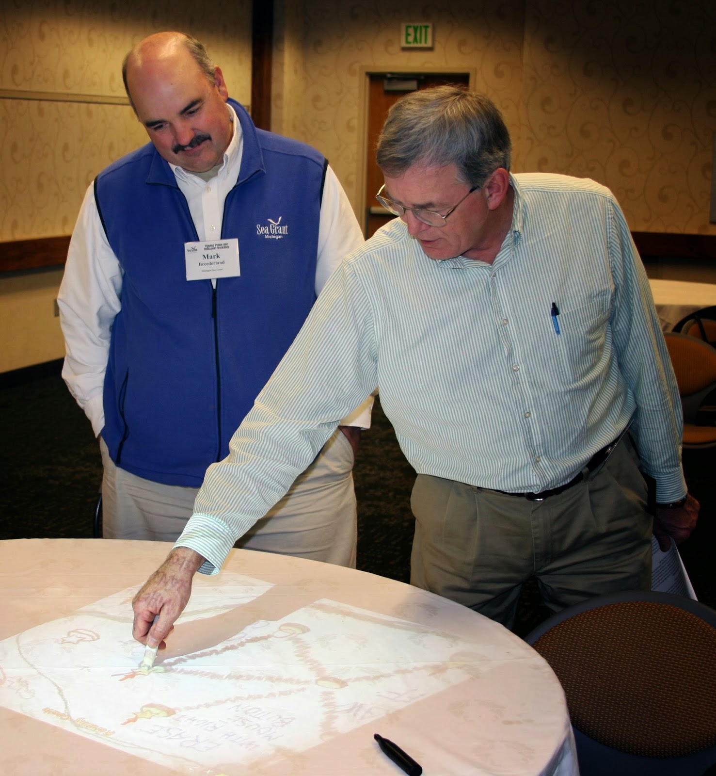
For land use planners, balancing community growth and environmental health is always a challenge. But after months of pilot testing, IISG is putting the final touches on a new web-based tool that will help them do just that.
 The Tipping Points and Indicators tool uses the latest watershed research and cutting-edge technology to show planners where aquatic ecosystems in their area are in danger of crossing a “tipping point,” triggering rapid and sometimes irreversible shifts in how they function. With help from a Sea Grant facilitator, planners can use the tool’s interactive maps, simulators, and recommended response strategies to develop watershed-specific plans that prevent ecosystems from being degraded beyond repair.
Specialists from Ohio, New York, Minnesota, Wisconsin, Michigan and Illinois-Indiana Sea Grant programs have spent the last few months testing the tool in broad range of communities and divers audiences. Planning groups from the industrialized southern Lake Michigan to the more preserved northern Wisconsin and Minnesota can now use the decision support system to kick off the watershed planning process. In Indiana, Ohio, and New York, facilitators have also introduced planning consultants and state employees to tool modules so they can take the process back to their own communities.
Experiences so far have been positive, with many users expressing excitement about the role Tipping Points and Indicators could play in improving watershed planning. Community members, local officials, and consultants were particularly interested in the tools’ recommended policies, ordinances, and outreach efforts tailored to local needs. In fact, a watershed advocacy group from the Duluth area mentioned they could have spent a whole day on that module alone.
 To further enhance the tool, users also recommended making maps and planning strategies more watershed-specific. Many of these refinements are being made now. Others, including the addition of the new land cover data and models that predict future tipping points, are expected in the coming months.
And as the project grows, so does the lead team. Last month, IISG brought Purdue software developer Brandon Beatty onboard to help boost the usability of Tipping Points and Indicators and ensure it continues to rely on the latest research and technology.
The tipping points tool is part of a four-year project funded by NOAA and EPA and coordinated by Illinois-Indiana Sea Grant. Partners include Purdue University, University of Michigan, Michigan State University, University of Minnesota Duluth, University of Windsor, Great Lakes Environmental Research Laboratory, the Cooperative Institute for Limnology and Ecosystem Research, the Great Lakes Restoration Initiative, and the Sea Grant Great Lakes Network.
July 2nd, 2014 by iisg_superadmin
Protecting fish populations worldwide while still meeting the steadily increasing demand for fresh seafood is a critical challenge facing several countries, but aquaculture (fish farming) is making significant advances in efficiency and sustainability that can meet those needs.
“Globally, we’ve hungered for 3.2 percent more seafood every year for the last five decades, double the rate of our population. Yet more than four fifths of the world’s wild fisheries are overexploited or fully exploited (yielding the most fish possible with no expected room for growth). Only 3 percent of stocks are considered ‘underexploited’—meaning they have any significant room for expansion. If we continue to fish at the current pace, some scientists predict we’ll be facing oceans devoid of edible marine creatures by 2050.
Aquaculture could come to the rescue. The Food and Agriculture Organization of the UN predicts that farmed fish will soon surpass wild-caught; by 2030, aquaculture may produce more than 60 percent of fish we consume as food.
One of the most pressing concerns about aquaculture, though, is that many farmed fish are raised on a diet of 15 million tons a year of smaller bait fish—species like anchovies and menhaden. These bait—also known as forage fish—are ground up and converted into a substance called fishmeal. It takes roughly five pounds of them to produce one pound of farmed salmon. Bait fish are also used for non-food products like pet food, makeup, farm animal feed, and fish oil supplements.
It may appear as though the ocean enjoys endless schools of these tiny fish, but they too have been mismanaged, and their populations are prone to collapse. They’re a ‘finite resource that’s been fully utilized,’ says Mike Rust of NOAA’s Fisheries arm. Which is disturbing, considering that researchers like those at Oceana argue that forage fish may play an outsize role in maintaining the ocean’s ecological balance, including by contributing to the abundance of bigger predatory fish.
And that’s where Belov’s trout come in: Though he swears no one can taste the difference, his fish are vegetarians. That means those five pounds of forage fish can rest easy at sea. It also means that the trout don’t consume some of the other rendered animal proteins in normal fishmeal pellets: like bone meal, feather meal, blood meal, and chicken bi-products.”
Read the complete article at the link above for more about recent developments in aquaculture, and visit our aquaculture page for further information.
June 16th, 2014 by iisg_superadmin
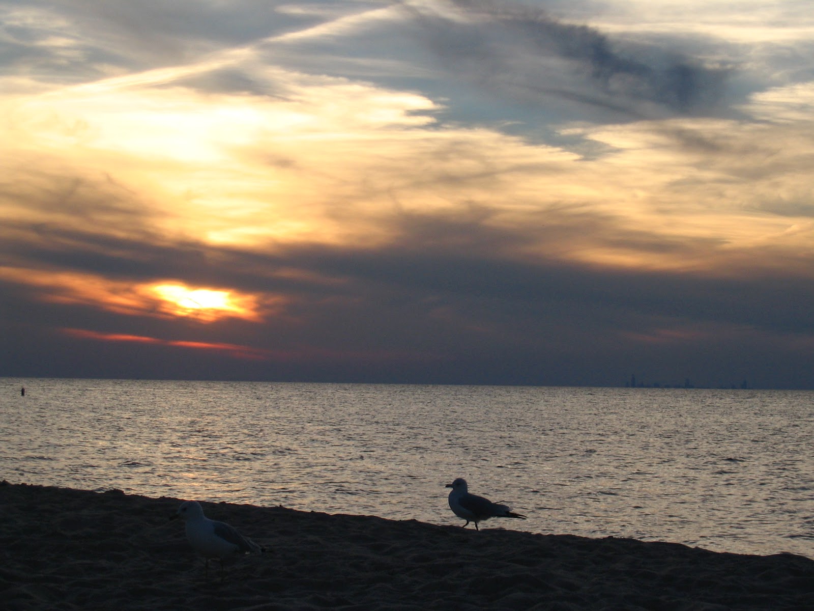
It’s beach season once again in southern Lake Michigan, and the rip current warnings have already begun.
The National Weather Service (NWS) has issued at least one advisory since Illinois and Indiana beaches opened last month asking beach-goers to think twice before taking a dip in the lake. And for good reason. Rip currents and other dangerous currents are the biggest threat to Great Lakes swimmers. Roughly 140 people have drowned in the lakes over the last 12 years due at least in part to dangerous currents. And most of those incidents happened in Lake Michigan.
Illinois-Indiana Sea Grant hopes to bring these numbers down with a new outreach effort that will raise awareness about dangerous currents in the Great Lakes. The “Implementing Dangerous Currents Best Practices” project was recently awarded funding from the NOAA Coastal Storms Program.
A collaborative effort Sea Grant programs in Michigan and Wisconsin, the project will include print and online resources—including educational videos—that introduce the science behind rip currents, provide tips for avoiding them, and explain what to do if you or others are caught in one. Many of these resources will be available in both English and Spanish.
Watch for further information on these outreach efforts and rip currents in the coming months. In the meantime, you can find tips for staying safe at the beach this summer at dangerouscurrents.org.
“Implementing Dangerous Currents Best Practices” continues years of efforts by Great Lakes Sea Grant programs, NOAA, and NWS to reduce dangerous currents drownings across the region. To learn more about these efforts, visit Rip Current Safety.
June 6th, 2014 by iisg_superadmin
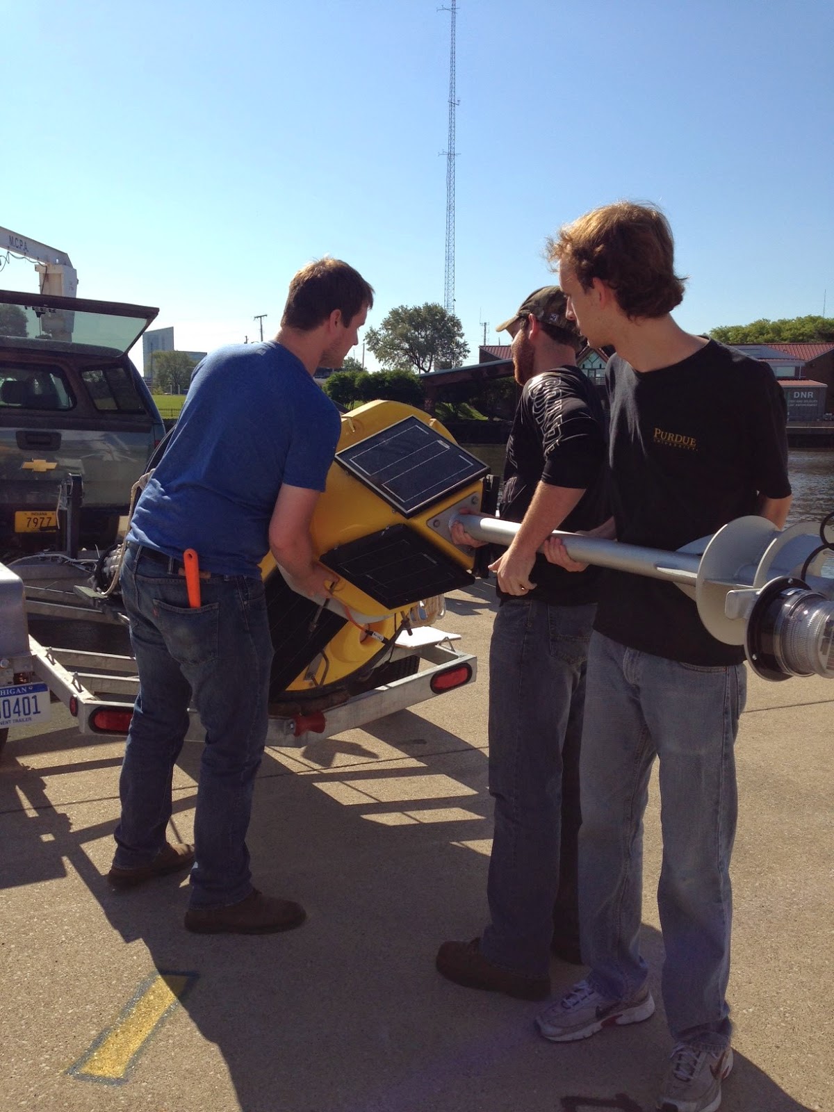
The Michigan City buoy returned to the nearshore waters of Lake Michigan on June 5—this time with an upgrade that boaters, anglers, and researchers have been eagerly awaiting. In addition to broadcasting real-time data on wave height and direction, wind speed, and air and surface water temperatures, the improved buoy now relays water temperatures at different depths.
The sensor chain, which measures water temperatures approximately every 3 ft. from the surface to the bottom of the lake, will help kayakers know when the water is warm enough to paddle out and make it easier for anglers to find and catch their favorite fish. A more comprehensive picture of nearshore water temperatures is also vital for research on fisheries and nearshore hydrodynamics.
“We’ve been getting a lot of positive feedback asking us when the buoy will be in the water again,” said Carolyn Foley, IISG assistant research coordinator. “And they’re all excited to hear that we’ve added a temperature chain to our setup. The nearest buoy with a similar chain is about 30 miles away.”
Real-time data will be available on IISG’s website until the buoy is pulled out for the winter in mid-October. The site currently shows snapshots of lake conditions—updated every 10 minutes—as well as trends over 24-hour and 5-day periods. Buoy-watchers can also download raw historical data at NOAA’s National Data Buoy Center.
Later this summer, IISG will be hosting a workshop designed to help educators develop science, math, and stewardship projects using the real-time buoy data. The workshop is scheduled for August 6 at Purdue University North Central.
April 2nd, 2014 by iisg_superadmin
While the spring thaw will be a welcome change of weather in most of the country, there is a risk that snow melt and spring rains could lead to rivers exceeding flood levels.
“The continuation of winter weather, above-average snowpack, frozen ground and thick ice coverage on streams and rivers will delay spring flooding into April in the upper Midwest eastward to New England.
The intensity of the flooding will depend on the rate of snow and ice melt, and future rainfall.
Continued well-below average temperatures this winter resulted in significant river ice formation and ice jams in locations further south than customary, flooding homes and businesses, and impacting river commerce.
There is also an elevated risk of more ice jams this spring in the northern tier of the U.S. from Montana eastward to northern New England.
‘This year’s spring flood potential is widespread and includes rivers in highly populated areas putting millions of Americans at risk,’ said Louis Uccellini, director, NOAA’s National Weather Service.
‘Although widespread major river flooding is not expected, an abrupt warming or heavy rainfall event could lead to isolated major flooding.'”
Read the rest of the article at the link above.
March 17th, 2014 by iisg_superadmin
Research into the Lake Michigan food web has increased in the last decade, but there are still a lot of questions—exactly what is eating what, and how is that dynamic affected by environmental changes? To find answers to these and other questions, researchers from federal and state agencies, universities, and non-profit organizations will come together next month in Ann Arbor, MI. The two-day meeting will feature discussions on past and current food web studies and end with a plan for future research.
The meeting kicks off April 1 with presentations on several Sea Grant- and EPA-funded studies. IISG’s Tomas Hook, Sergiusz Czesny, director of the Lake Michigan Biological Station, and Bo Bunnell of the USGS Great Lakes Science Center will discuss the state of Lake Michigan fish populations, including the results of a three-year investigation of the differences in nearshore food webs across the lake. Harvey Bootsma, a researcher at the University of Wisconsin-Milwaukee, and NOAA’s Henry A. Vanderploeg will also be onsite to talk about recent findings on the diets of phytoplankton, algae, and other species at the bottom of the food chain. Additional presentations, orchestrated by IISG’s Paris Collingsworth and featuring IISG-funded scientist Cary Troy, will talk about research on the physical dynamics of the lake and steady flow of nutrients brought in by stormwater runoff—two important factors affecting food web structures. Paris will also introduce plans for upcoming monitoring and field activities in Lake Michigan as part of the Cooperative Science and Monitoring Initiative.
Conversations on the second day will turn to planning. IISG research staff will team up with representatives from the Wisconsin and Michigan Sea Grant programs to lead discussions on data still needed to understand how invasive species, contaminants, climate change, and other factors are affecting the Lake Michigan food web. Meeting attendees will also have an opportunity to briefly talk about their research and where they hope to go next. The gaps and next steps identified will help Lake Michigan Sea Grant programs identify research projects to fund in the coming years.
This meeting is the third of its kind since 2008. And, like those before it, this year’s meeting is coordinated by IISG and GLRRIN Lake Michigan partners from Wisconsin Sea Grant, Michigan Sea Grant, the NOAA Great Lakes Environmental Research Laboratory, the US EPA Great Lakes National Program Office, and the USGS Great Lakes Science Center. Previous meetings helped launch the 2010 Lake Michigan Intensive Monitoring Field Year and resulted in roughly $1.7 million in funding for food web projects.
