December 4th, 2014 by iisg_superadmin
With that nip in the air and the occasional snow flurries, it’s hard to deny that winter is almost here. Will this year be as cold as last? Molly Woloszyn tackles this complicated question.

After a mild start to fall, November abruptly turned cold in the Midwest, giving us an early dose of winter. One of the coldest days was November 17th, when maximum daily temperatures of less than 30°F were widespread across the region—parts of southern Minnesota and northern Iowa only reached the single digits. With a preliminary average temperature of 31.4°F, November 2014 is now the Midwest’s sixth coldest November since records began in 1895.
But things are shaping up to be a little different for December. In fact, NOAA’s Climate Prediction Center (CPC) is now predicting a pattern change for at least the next two weeks. This means there’s a good chance that a majority of the United States will experience much milder conditions, with above-normal temperatures expected through the middle of the month. This isn’t necessarily surprising. We have a couple of examples in the past where record cold Novembers gave way to normal or warmer winters.
So, the question on all of our minds is “What does the rest of the 2014-2015 winter have in store for us Midwesterners?”
I wish I had a formula to tell you exactly what to expect. Accurate seasonal outlooks are always difficult to provide. But predictions are especially difficult this year because there is no strong signal or driver in the atmosphere.
What do I mean by “signal” or “driver”? I am talking about phenomenon like El Niño, which is the existence of unusually warm sea surface temperatures in the equatorial Pacific Ocean. Believe it or not, this can have major implications across the country. In the Midwest, winters tend to be warmer than normal—and drier in some places—when there is a strong El Niño. There is a 65 percent chance El Niño could develop this winter. However, if it emerges, it is likely to be weak, making it an undependable driver when it comes to this winter’s outlook.
 A few seasonal outlook approaches are pointing to the possibility for a colder-than-normal winter in the Midwest. For instance, some research suggests that there is a strong correlation between rapid snow advancement and its overall extent across Siberia and Eurasia during October and colder-than-normal winter temperatures and more snowfall in the eastern United States. In October 2014, snow cover advance and extent across Eurasia was the 2nd highest in the satellite era, suggesting it could be a cold and snowy winter here in the Midwest.
This prediction is supported by another phenomenon we are seeing in the central and northern Pacific Ocean. A positive Pacific Decadal Oscillation (PDO), which represents a warmer-than-normal pattern of sea surface temperatures, tends to encourage colder conditions in the eastern US. The PDO has been predominantly negative since the late 1990s, but it shifted to positive in 2014.
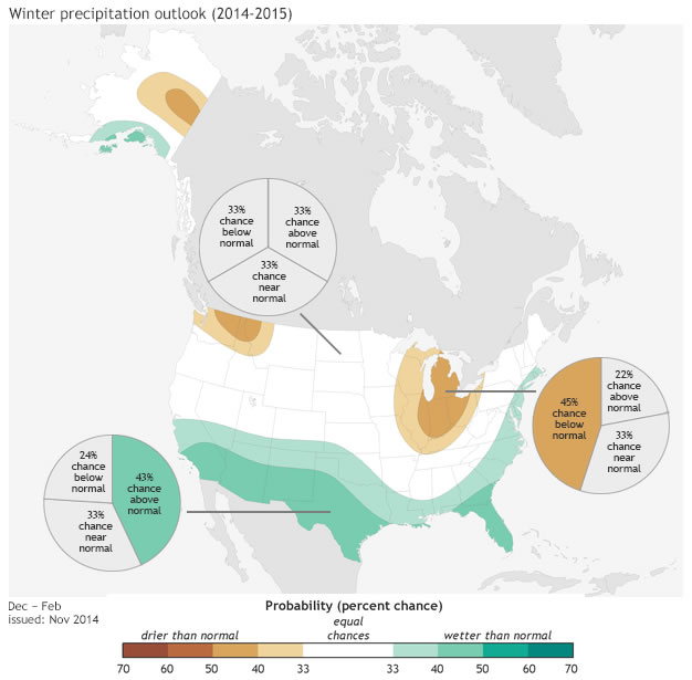
Even if a colder winter is in our future, it may not necessarily be a white one. NOAA’s CPC is predicting greater chances of below-normal precipitation in portions of the eastern Midwest, which is also related to the possibility for weak El Niño development. There is no clear signal for the rest of the region.
Of course, we will have more information on winter weather predictions as they come in. In the meantime, enjoy the more mild temperatures most likely in store for the next few weeks.
***Special thanks to the Chicago National Weather Service for providing some of this information, which came from their winter 2014-15 outlook.
Photo A: 24-hour maximum temperatures ending the morning of Nov. 18. 2014.
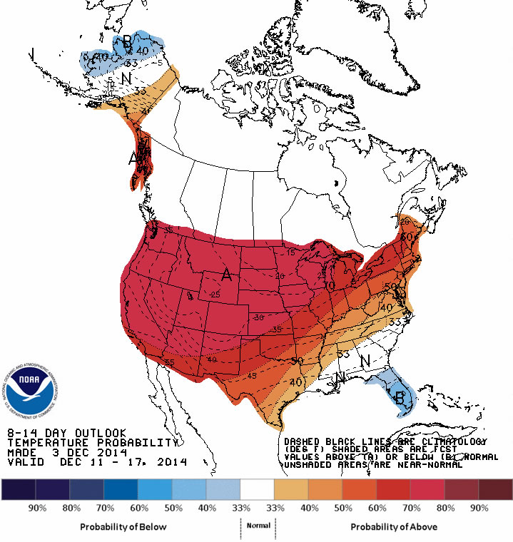
Photo B: The outlook for Dec. 10-16 from the Climate Prediction Center. Red shading represents areas with greater chances for above-normal temperatures.
Photo C: Winter temperature outlook for Dec. 2014 – Feb. 2015. Map by NOAAclimate.gov based on data from the Climate Prediction Center.
Photo D: Winter precipitation outlook for Dec. 2014 – Feb. 2015. Map by NOAAclimate.gov based on data from the Climate Prediction Center.
July 18th, 2014 by iisg_superadmin
It probably comes as no surprise to those living in the Great Lakes region to hear that this spring was one of the coldest on record. Since 1948, there have been only four years with lower spring temperatures. And these unusually cold temperatures—and the snow that came with them—had significant impacts on Great Lakes ecosystems, communities, and economies.
These impacts are the focus of the latest edition of the Great Lakes Quarterly Climate Impacts and Outlook report. Released in June, the report details how the long winter helped lake levels rebound from record lows, forced cities to invest more in winter operational expenses and infrastructure maintenance, and has left some farmers concerned about this year’s crop. It also provides a look at expected temperatures and precipitation levels for the coming months.
The Great Lakes Quarterly Climate Impacts and Outlooks is developed by NOAA and Environment Canada. Past editions, as well as reports for other regions, are available at the U.S. Drought Portal.
July 15th, 2014 by iisg_superadmin
Boaters, anglers, and swimmers, you many want to think twice before heading out into Lake Michigan today. Forecasters are predicting waves swells as high as 7 ft, creating dangerous conditions for any one in water.
The high waves are the result of an unusual weather pattern expected to continue into tomorrow. A small piece of the polar vortex has dropped down to the southern Great Lakes, bringing fall-like weather to parts of Michigan, Wisconsin, Illinois, and Indiana.
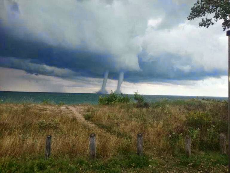
The cool air may be a welcomed break from July heat, but the shifting weather is not without its downsides. Right now, parts of the lake are actually warmer than the air above it, creating the perfect conditions for waterspouts. The wave swells created by gusty winds also bring a higher chance of rip currents, especially along Michigan’s western shore.
Whether you are planning a trip to the lake or not, you can track wave height and other lake conditions in southern Lake Michigan as the strange weather continues with the IISG real-time buoy.
*The week’s strange weather brings a chance of waterspouts like this one captured near Winthrop Harbor in 2013. Photo by Phil Mathis.
June 12th, 2014 by iisg_superadmin
Summer and winter may look a little different this year. The National Weather Service Climate Prediction Center is reporting warmer temperatures in the Pacific Ocean along the equator, which could mean big things in the Midwest and around the world.
The global weather phenomenon is known as El Nino. It occurs every few years when a giant band of water in the tropical Pacific Ocean becomes unusually warm. This sets off a chain reaction of weather events that have historically resulted in severe droughts in portions of India, Southeast Asia, Australia, and South America. In contrast, El Nino often brings heavy rains to the West Coast.
The effects are a little milder in the Midwest, which is likely to see cooler summers and winters with less snowfall. Some parts of the region might even have better corn and soybean yields thanks to the milder temperatures.
El Nino events are difficult to predict, and there is no guarantee we will experience one this year. A recent advisory from the Climate Prediction Center, though, puts the chance of El Nino as high as 80 percent.
Keep an eye on the developing El Nino with weekly updates from the National Weather Service. And for more information on climate trends and changes in the Midwest, visit the Midwestern Regional Climate Center.
*Photo courtesy of the National Weather Service.
May 14th, 2014 by iisg_superadmin
The National Weather Service’s Weather-Ready Nation initiative was begun to help communities throughout the country better prepare for and respond to severe weather events. Much of that preparedness has to do with increasing the speed, accuracy, and effectiveness of weather monitoring and warning mechanisms on the local level. And finding the strongest ways to communicate weather messages to residents is key.
That is why, as part of the Weather-Ready Nation project, the Great Lakes Social Science Network conducted extensive research into the most effective impact-based warnings. Their report, “Evaluation of the National Weather Service Impact-based Warning Tool,” utilized interviews, focus groups, and surveys to determine the most and least effective ways for broadcast meteorologists and emergency managers to communicate these warnings to the public.
National Weather Service piloted an impact-based warning system in 2012 in five select offices, and expanded it to the central region’s 38 offices in 2013. The report offers a sort of mid-term evaluation of the system’s effectiveness and stakeholders’ perceptions of it, while also providing recommendations for further training and implementation improvements.
This research was a team effort between representatives from five Great Lakes Sea Grant programs. Caitie McCoy and Leslie Dorworth from Illinois-Indiana Sea Grant were involved, as well as Dr. Jane Harrison (Wisconsin Sea Grant), Dr. Kathy Bunting-Howarth (New York Sea Grant), Hilarie Sorensen (Minnesota Sea Grant), Katie Williams (University of Wisconsin-Milwaukee), and Dr. Chris Ellis (NOAA Coastal Services Center). The report was presented earlier this year to the Social Coast Forum in Charleston, SC, sparking a number of other groups and agencies to inquire about the report and possible opportunities to expand on it with further research.
For further information about the Great Lakes Social Science Network, as well as training and future research projects, visit the link above.
April 24th, 2012 by Irene Miles
Natural weather cycles, extreme conditions, and other issues can arise anywhere, and particularly in areas near coastlines. Residents near rivers and lakes are often aware of the potential for season flooding and other weather concerns, but may not be fully prepared for all of the possibilities. Additionally, each area of the country has the potential for unique weather concerns, such as flooding or tornadoes here in the Midwest.
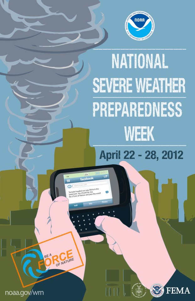
As part of a campaign to Build a Weather-Ready Nation, the National Oceanic and Atmospheric Association and the Federal Emergency Management Agency are joining forces with Sea Grant programs across the country. The campaign invites everyone to Be a Force of Nature by taking certain steps that can help you and your community be prepared for inclement weather and the dangers associated with weather events.
 Some important steps taken now can make a big difference later, including:
Knowing your risk – Being aware of impending weather events and aware of risks associated with areas you live and work in (i.e. potential flooding, tornadoes, strong winds, etc.)
Take action – Develop an emergency plan that the whole family knows about. This can include information such as where to meet in the event of an emergency, ways to stay in contact with one another, and other important details.
Be a Force of Nature – Once you have a plan, share the information, resources, and more with friends, family, neighbors, co-workers, and anyone else. You can visit the links above and share information directly from those Facebook pages, as well as spreading the word through other means. Sharing these simple steps with others is one great way to help everyone stay safe.


