While this year’s strong El Niño may play havoc in other parts of the country and the world, in the Great Lakes region it’s likely that we won’t need to talk about the polar vortex and the “snowpocalypse” this winter.
The Climate Prediction Center at NOAA is forecasting an increased chance of above-normal temperatures and a greater chance for below-normal precipitation across most of the Great Lakes region this winter.
“This does not mean that cold weather will not happen this winter,” said Molly Woloszyn, IISG climate specialist. “But typical extreme cold weather may be milder and less frequent.”
An El Niño develops when sea surface temperatures are warmer than average in the equatorial Pacific for an extended period of time. This year’s version is already considered to be strong and likely to become a bit stronger. Although each El Niño is different, they offer some predictable patterns.
 Unlike the past two winters when heavy snow and bitter cold were the norm, if warmer conditions do occur this winter, this may mean less ice cover on the lakes. It might also mean reduced snowpack accumulation and therefore, less runoff into the lakes, which is a major contributor to lake levels.
Also, less lake ice means more evaporation off the lake surfaces. “Since the lakes are mostly at above average levels right now, this could lead to a return to normal water levels,” said Woloszyn.
Mild winters can have many positives impacts in the region. They are typically good for the economy (unless you are in the snow business)—heating costs go down, transportation runs smoother, and retail sales pick up. And they are generally good for agriculture, although some crop pests are more likely to survive the winter.
With that nip in the air and the occasional snow flurries, it’s hard to deny that winter is almost here. Will this year be as cold as last? Molly Woloszyn tackles this complicated question.

After a mild start to fall, November abruptly turned cold in the Midwest, giving us an early dose of winter. One of the coldest days was November 17th, when maximum daily temperatures of less than 30°F were widespread across the region—parts of southern Minnesota and northern Iowa only reached the single digits. With a preliminary average temperature of 31.4°F, November 2014 is now the Midwest’s sixth coldest November since records began in 1895.
But things are shaping up to be a little different for December. In fact, NOAA’s Climate Prediction Center (CPC) is now predicting a pattern change for at least the next two weeks. This means there’s a good chance that a majority of the United States will experience much milder conditions, with above-normal temperatures expected through the middle of the month. This isn’t necessarily surprising. We have a couple of examples in the past where record cold Novembers gave way to normal or warmer winters.
So, the question on all of our minds is “What does the rest of the 2014-2015 winter have in store for us Midwesterners?”
I wish I had a formula to tell you exactly what to expect. Accurate seasonal outlooks are always difficult to provide. But predictions are especially difficult this year because there is no strong signal or driver in the atmosphere.
What do I mean by “signal” or “driver”? I am talking about phenomenon like El Niño, which is the existence of unusually warm sea surface temperatures in the equatorial Pacific Ocean. Believe it or not, this can have major implications across the country. In the Midwest, winters tend to be warmer than normal—and drier in some places—when there is a strong El Niño. There is a 65 percent chance El Niño could develop this winter. However, if it emerges, it is likely to be weak, making it an undependable driver when it comes to this winter’s outlook.
 A few seasonal outlook approaches are pointing to the possibility for a colder-than-normal winter in the Midwest. For instance, some research suggests that there is a strong correlation between rapid snow advancement and its overall extent across Siberia and Eurasia during October and colder-than-normal winter temperatures and more snowfall in the eastern United States. In October 2014, snow cover advance and extent across Eurasia was the 2nd highest in the satellite era, suggesting it could be a cold and snowy winter here in the Midwest.
This prediction is supported by another phenomenon we are seeing in the central and northern Pacific Ocean. A positive Pacific Decadal Oscillation (PDO), which represents a warmer-than-normal pattern of sea surface temperatures, tends to encourage colder conditions in the eastern US. The PDO has been predominantly negative since the late 1990s, but it shifted to positive in 2014.
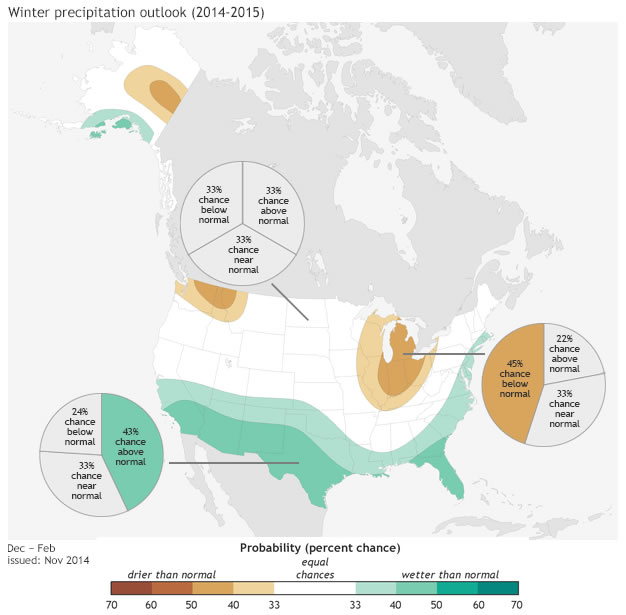
Even if a colder winter is in our future, it may not necessarily be a white one. NOAA’s CPC is predicting greater chances of below-normal precipitation in portions of the eastern Midwest, which is also related to the possibility for weak El Niño development. There is no clear signal for the rest of the region.
Of course, we will have more information on winter weather predictions as they come in. In the meantime, enjoy the more mild temperatures most likely in store for the next few weeks.
***Special thanks to the Chicago National Weather Service for providing some of this information, which came from their winter 2014-15 outlook.
Photo A: 24-hour maximum temperatures ending the morning of Nov. 18. 2014.
Photo B: The outlook for Dec. 10-16 from the Climate Prediction Center. Red shading represents areas with greater chances for above-normal temperatures.
Photo C: Winter temperature outlook for Dec. 2014 – Feb. 2015. Map by NOAAclimate.gov based on data from the Climate Prediction Center.
Photo D: Winter precipitation outlook for Dec. 2014 – Feb. 2015. Map by NOAAclimate.gov based on data from the Climate Prediction Center.
Summer and winter may look a little different this year. The National Weather Service Climate Prediction Center is reporting warmer temperatures in the Pacific Ocean along the equator, which could mean big things in the Midwest and around the world.
The global weather phenomenon is known as El Nino. It occurs every few years when a giant band of water in the tropical Pacific Ocean becomes unusually warm. This sets off a chain reaction of weather events that have historically resulted in severe droughts in portions of India, Southeast Asia, Australia, and South America. In contrast, El Nino often brings heavy rains to the West Coast.
The effects are a little milder in the Midwest, which is likely to see cooler summers and winters with less snowfall. Some parts of the region might even have better corn and soybean yields thanks to the milder temperatures.
El Nino events are difficult to predict, and there is no guarantee we will experience one this year. A recent advisory from the Climate Prediction Center, though, puts the chance of El Nino as high as 80 percent.
Keep an eye on the developing El Nino with weekly updates from the National Weather Service. And for more information on climate trends and changes in the Midwest, visit the Midwestern Regional Climate Center.
*Photo courtesy of the National Weather Service.
 Unlike the past two winters when heavy snow and bitter cold were the norm, if warmer conditions do occur this winter, this may mean less ice cover on the lakes. It might also mean reduced snowpack accumulation and therefore, less runoff into the lakes, which is a major contributor to lake levels.
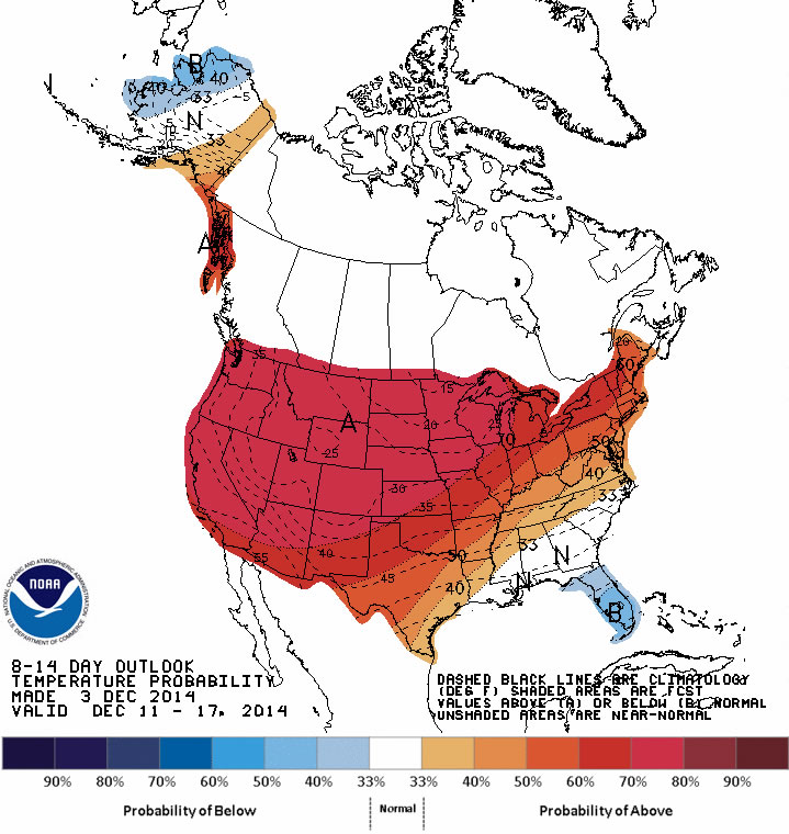


