October 17th, 2017 by iisg_superadmin
Illinois-Indiana Sea Grant (IISG) plans to award $675,000 to four new research projects that will help inform decision makers as they address some of the region’s pressing environmental issues, including managing stormwater, restoring stream habitats and protecting beachfronts. The research will take place in 2018-2019.
Two projects will focus on green infrastructure as part of stormwater management, but using different approaches. At the University of Illinois, landscape architect Mary Pat McGuire will lead a diverse team that includes David Grimley with the Illinois State Geological Survey (ISGS) to create a soils database for the Calumet region southeast of Chicago to assess soil health and appropriateness for effective green infrastructure. The researchers will evaluate green infrastructure planning in the region and work with municipalities in pilot projects to help integrate their findings into site selection and design strategy decisions.
Bernie Engel and colleagues in the Purdue University Department of Agricultural and Biological Engineering will enhance their simulation software to include the long-term effects of green infrastructure on reducing and preventing flooding. Their model is part of the Tipping Point Planner online toolbox, which helps local decision makers plan for future development in their communities. This new project will be closely tied to a south side Chicago neighborhood—Washington Park. There, using their updated model, the research team hopes to demonstrate the impact of optimally-places green infrastructure on flooding. Akilah Martin, in DePaul University’s School for New Learning, will help share these results with students and local residents.
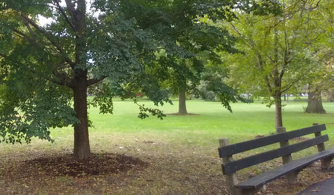
Washington Park, Chicago, Illinois
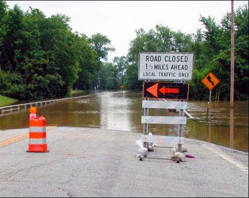
At the University of Illinois, hydrogeologist Piotr Cienciala and ecological physiologist Cory Suski will lead a multi-disciplinary project to study the effect of turbulence on fish swimming behavior. By studying how the physiology of various fish species is affected by water movement, the researchers can help inform the placement of fish passage structures as part of stream restoration projects. The findings will likely be transferable to stream projects beyond the Great Lakes region and may help inform simulations to explore restoration outcomes under various projected climate or land use change scenarios that alter water movement and fish habitat.
U of I researchers will also use historical documents of the geology of the Illinois shoreline to help beach managers predict and address future conditions. Through old photos and reports, ISGS’s Ethan Theuerkauf will lead an effort to tell the story of land changes and environmental conditions over the last century at Illinois Beach State Park. Experts from the Prairie Research Institute, Midwest Regional Climate Center, and Great Lakes Integrated Sciences and Assessment Center are also taking part in this research. Working closely with beach managers, the researchers will develop future coastal change scenarios to help inform the decision making process.
“Illinois-Indiana Sea Grant is excited to support these new research efforts,” said Tomas Hook, IISG associate director for research. “They are targeting issues that have been identified as priorities for the Lake Michigan region of Illinois and Indiana and they have great potential to yield solution-based results for our region. Collectively, these projects should also contribute to informing infrastructure and environmental management in coastal regions throughout the United States.”
Illinois-Indiana Sea Grant is a part of University of Illinois Extension and Purdue University Extension.
December 15th, 2015 by iisg_superadmin
Flooding is always hard on a community, but when hospitals, mass transit, utilities, and others that impact the health and safety of residents are under water, these facilities may not be able to provide critical services or may even be forced to shut down. This leaves residents and businesses vulnerable to other threats and makes flood recovery ever more challenging.
The heart of the project is the Flood Vulnerability Assessment for Critical Facilities, which is an assessment tool. This set of questions will help Cook County managers determine a facility’s risk based on factors like its proximity to a flood plain, past flooding issues, stormwater drainage systems, and the location of key systems like back-up generators and computer servers. Facilities may also be able to use the tool to evaluate current emergency communication plans for heavy rainfall and determine whether improvements are necessary. After a pilot phase, the final assessment tool will be made available online for facilities beyond Cook County.
What’s more, to help managers plan with an eye on the future, the project team will use historic rainfall data and climate forecasts to pinpoint the frequency of heavy storms now and predict how that rate may change as the climate does. The Reducing Flooding Vulnerability of Chicago Critical Facilities project is led by Molly Woloszyn, IISG and MRCC extension climate specialist, and Beth Hall, MRCC director, with additional support from the
Coordinated Hazard Assessment and Mapping Program at the Illinois StateWater Survey. Funding is provided through the National Sea Grant Office as part of the Community Climate Adaptation Initiative, which is focused on helping communities prepare for climate change.
This story appears in the latest edition of The Helm.
October 21st, 2015 by iisg_superadmin
It is not uncommon for more than one home on a block to have excess water due to stormwater runoff. The good thing about a rain garden is that they can adapt to suit the need of the homeowner. They can be placed wherever on the property they are needed.
Originally Dan and Libby Reimann’s Mount Prospect, Ill. home did not have any problems with standing water. It was not until the couple had an addition built onto their house did they encounter problems. During the construction, their sump pump began to run continuously, flooding their front yard and a portion of the neighbor’s driveway. When the couple contacted local authorities, they were given two suggestions, the Reimanns could tap into the sewer system or they could build a rain garden.
The couple didn’t want to tap into the sewer system if they could avoid it and the village encouraged the idea of a rain garden. With some deliberation as well as online searching and learning more about rain gardens, Dan and Libby decided they would try to build one.
In Dan’s research he came across Kevin Herbert, a landscaper in the northwest suburbs of Chicago. They contacted Herbert to design and construct their garden. Not knowing exactly what they wanted or what to put in the garden, they gave Herbert free reign. From the shape of the garden to the flowers in the garden, Herbert did it all.
 Not only did Herbert take charge of the whole design process but he also helped in the garden’s maintenance. The couple hired him to take care of the garden following its first year of installment. In that year he taught them what to weed, when to cut down plants and provided the couple with pictures of what each plant should look like when fully grown as a way to tell them apart. He left them the initial sketch of the design of the garden with what flowers go where.
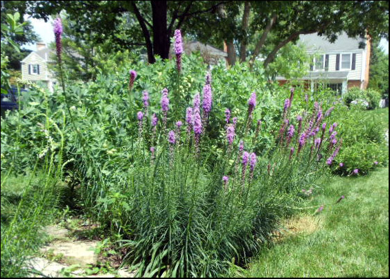
The Reimann garden is full of blooming flowers. They were particularly happy with the selection because they were picked to ensure that flowers are always in bloom, spring through fall. In the spring, the garden is adorned by blue and pink from the blue flags, blazing star and prairie smoke. When summer begins, the Reimanns can start to see white, purple and yellow from the meadowsweet, Monarda and black-eyed Susans. Black-eyed Susans are joined by white turtlehead and New England asters bloom in the late summer to early fall. The garden keeps these colors until the frost.
Dan’s advice to homeowners who know little to nothing about rain gardens, is to not let fear stop them. “They should just go for it,” Dan said. “And don’t be afraid to ask for help.”
When their neighbor Amy Hempleman saw how well the garden was working she took his advice, even taking their suggestion of having Herbert help create their garden in the spring of 2014.
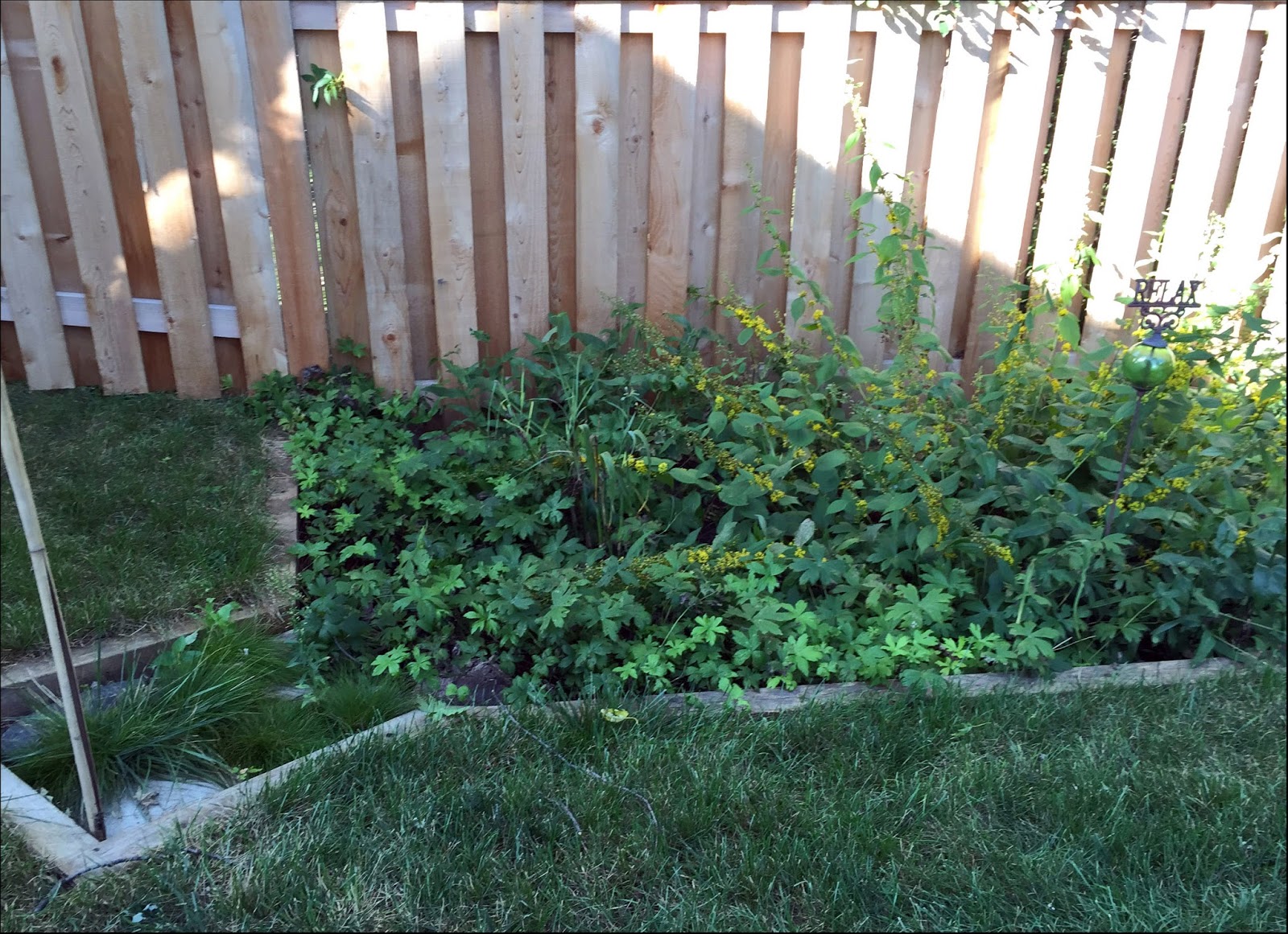
 The Hempleman garden was different in one major way—the location. While water was spilling into the front of the Reimann’s yard, Hempleman had to solve a problem in the backyard. The back corner just behind the garage began to flood from excess water coming from the gutters. Hebert used this as well as the natural slope of the yard to his advantage when he designed this garden. The water is routed along the sidewalk downspout and into the garden.
Hempleman is very happy with the garden, describing it as attractive and bright in the summer. When in full bloom, the garden has bluejackets, broad leaf goldenrod, nodding onion as well as ivory sedge and plantain leaved sedge. The balance between flowers and grass-like plants creates a full garden that does its job as well as adding to Hempleman’s yard.
Not only was Hempleman happy with the garden’s appearance, but she also feels good about the way it took care of the water problem. This experience has given Hempleman a new interest in plants, to be more specific, with native plants. As she has seen the beauty and functionality of them firsthand, she has started to notice and look for them. She expressed a wish for clearer labels of plants, to make it easier for gardeners that want to find native plants. This would also educate people who may not know the native plants of their area and could pique their interest.
Hempleman looks forward to watching her garden grow in the upcoming years.
-Victoria Figueroa
June 8th, 2015 by iisg_superadmin
Enough rain fell in Texas over the past month to cover the entire state in more than eight inches of water. The Trinity River in Dallas has risen to levels not seen in over 25 years. Flooding has resulted in $45 million worth of damage in Houston alone, and at least 31 people have died, with 10 still missing. As recovery in the Lone Star State begins, it becomes clear just how important urban flood management is, not only for the safety of people, but for the health and well being of the environment. Next month, Chicago, no stranger to flooding itself, will be the host location to a workshop confronting these very issues.

On July 8, IISG climate specialist Molly Woloszyn will be overseeing the next Resilient Chicago workshop: Urban Flood Management through No Adverse Impact and Green Infrastructure.Following up on a workshop from last year, this free, one-day event offers local government staffers and other interested professionals the opportunity to learn how to prepare for flooding in a more efficient and ecologically-conscious way. City planners, engineers, and members of non-profit organizations are called to gather at Loyola University to hear presentations from the Association of State Floodplain Managers, the Metropolitan Planning Council, the City of Chicago, and many others.
The two primary foci of the workshop will be how to apply No Adverse Impact (NAI) floodplain management and integrating green infrastructure into comprehensive and capital improvement planning. By focusing on NAI floodplain management, the workshop will provide potential management solutions that can be applied from strictly flooding related problems to issues like water quality protection and stormwater management. And in showcasing the potential for green infrastructure, attendees will learn how to cope with the increased potential for soil saturation that comes with urban development. The workshop will be sponsored by ASFPM, and the NOAA Coastal Storms Program.
.
February 17th, 2015 by iisg_superadmin
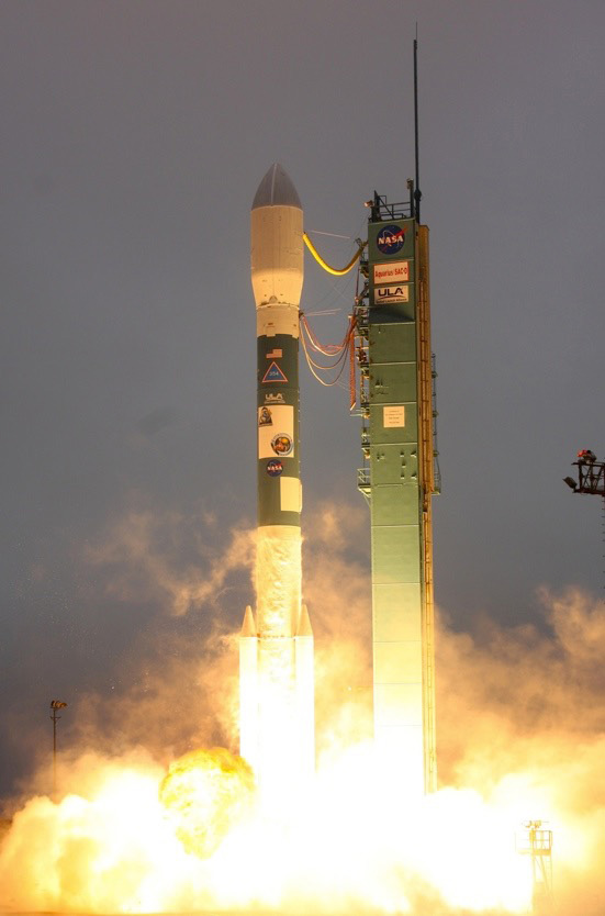 The mission of NASA’s newest Earth satellite may sound simple, but its findings could have huge impacts across the world and right here in the Midwest. When it launched last month, the Soil Moisture Active Passive, or SMAP, began a three-year project to collect data on a key player in the water and carbon cycles that determine plant growth and drive weather patterns: soil moisture. IISG’s Michael Brennan has the details.
 As the name suggests, soil moisture data tells us how much water the soil can absorb and store. These measurements play a crucial role in everything from knowing when to plant crops to community flood planning. If there isn’t enough moisture in the soil, plants can’t take root and grow. And if the soil’s storage capacity has been maxed out, any additional rain or snowfall will runoff into nearby rivers and lakes—carrying nutrients and contaminants with it.
Due to the earth’s vast landscape, tracking and assessing soil moisture is extremely challenging, especially in remote locations. In fact, a lack of detailed soil moisture data has historically been a significant hurdle for community planners, farmers, and climate and weather forecasters. SMAP has the potential to change all of that. Its microwave radiometer and radar instruments will give us the most accurate, high-resolution moisture data ever collected from space. And its orbital path will ensure we have measurements from pole to pole.
NASA has said that it expects to release the first set of measurements within nine months, with fully-validated data expected in 15 months. With these numbers in hand, farmers will be able to hone in on the ideal time for planing and harvesting and community decision makers will be able to pinpoint their flood risk—and plan accordingly. The data will also tell scientists how much carbon is being stored in or released by plants, allowing them to refine the climate models that we rely on to predict and prepare for the impacts of climate change.
The NASA space program is responsible for a lot of technological and scientific advancements, but SMAP may be its greatest contribution yet.
For more information on SNAP for video showing its launch and orbit, visit smap.jpl.nasa.gov/.
July 31st, 2014 by iisg_superadmin
In July, the Taste of Chicago closed down for a day due to heavy rain. In the suburbs, storms are flooding streets and basements. It’s a rainy year—the month of June had the third highest rainfall at Chicago O’Hare since records have been kept in 1959.
City sewers built to take on storms from days gone by are no match for today’s rainfall that lands mostly on parking lots, streets, and sidewalks instead of being absorbed into fields and patches of forest. What’s more, climate change predictions appear to be coming true—larger storms are hitting more frequently.
Basements and streets underwater are a serious concern, but when Superstorm Sandy hit the east coast two years ago, it illustrated that flooding of critical facilities, such as hospitals, can have widespread and possibly catastrophic impacts.
IISG’s climate specialist, Molly Woloszyn, is tackling the issue of flooding from the angle of better preparation and prediction. She is part of a project that is assessing the flooding vulnerability of critical buildings in Chicago, including utility providers, transportation facilities, and hospitals. She is looking at factors like location, elevation, and flooding history of the facility, but also the placement of critical systems, such as generators and potable water supplies. Ultimately, this will result in recommendations on how these facilities can shore up their structures and systems to reduce this risk in the face of future storms.
Molly and other project contributors at the Midwestern Regional Climate Center are also dipping into 25 years of data from the Cook County Precipitation Network to connect large rain events with their consequences, such as combined sewer overflows and reports of basement and viaduct flooding. The goal here is to help the National Weather Service make forecasts that are impact-based for the city of Chicago.
Updating rain event reports for what constitutes a 5-year storm or a 100-year storm, for example, (meaning the probability of these storms happening is 1 in 5 or 1 in 100 years) is one part of the city’s plan for getting ahead of flooding concerns as detailed in the City of Chicago Green Stormwater Infrastructure Strategy. Planners and engineers use long term rainfall data to make decisions going forward, but the last report was released in 1992 with data up to the mid-80s. By all accounts, big storms are getting bigger and more frequent. More data is key for local decision makers. The Midwestern Regional Climate Center’s analysis of the Cook County data will provide new rainfall thresholds for various sized events over the course of the last 25 years.

