June 5th, 2014 by iisg_superadmin
With the harsh winter behind us, things on the Great Lakes should be warming up for summer. But thanks in part to the harsh winter’s extensive ice cover, Lake Superior’s surface water temperature is predicted to be its lowest since 1979.
“In a follow-up to evaporation studies funded by the Great Lakes Integrated Sciences and Assessments Center, a federally funded collaboration between U-M and Michigan State University, Lenters and his colleagues developed a map-based water-temperature forecasting tool called SLATE, which stands for Seasonal Lake Temperature Energetics model.
The experimental model was used to generate the Lake Superior forecast and may later be used to create similar surface-water temperature forecasts for all five Great Lakes—possibly even evaporation forecasts. SLATE is believed to be the first map-based forecasting tool that shows anticipated variations in surface-water temperature from place to place across one of the Great Lakes.
The Lake Superior forecast is expected to be of interest to swimmers, boaters, anglers and others who will be affected by chilly water temperatures not seen since perhaps as far back as 1979.
‘If you’re planning to go swimming in Lake Superior this summer, you should probably stay close to shore,’ said Peter Blanken, a co-investigator from the University of Colorado.
The U.S. Coast Guard in Marquette has already expressed interest in using the Lake Superior forecast to help plan summer search-and-rescue operations. And a long-distance swimmer who is planning a trek from Milwaukee to Chicago in Lake Michigan this summer has also asked about water temperature forecasts.”
Read more about the temperature forecast as well as predictions about Lake Superior’s water levels at the link above.
May 21st, 2014 by iisg_superadmin
It has been nearly one year since IISG set sail on Lake Michigan to sample for plastic pollution. Since then, Sam Mason, a chemist from State University of New York Fredonia, and her research team have been hard at work analyzing those water samples. The initial results are revealed in the latest edition of IISG’s interview series UpClose.
In this issue, Mason talks about her ongoing work to quantify plastic pollution in the Great Lakes for the first time. In addition to the Lake Michigan results, Mason discusses plastic levels in the other four lakes, explains how plastics could impact aquatic wildlife, and suggests additional research needed to understand this emerging contaminant.
This is the sixth edition of UpClose, which takes readers behind the scenes of the latest research on pharmaceuticals and personal care products. Each interview targets a different component of PPCP research—everything from what happens to pharmaceuticals when water is treated to what bacterial resistance could mean for other aquatic wildlife living in urban rivers. Readers also get an insider’s view of the complex, and sometimes tricky, process of conducting field studies, and the potential implications of research on industries and regulations.
Read previous issues of UpClose at unwantedmeds.org. For print copies, contact Pollution Prevention Program Specialist Laura Kammin.
May 14th, 2014 by iisg_superadmin
The National Weather Service’s Weather-Ready Nation initiative was begun to help communities throughout the country better prepare for and respond to severe weather events. Much of that preparedness has to do with increasing the speed, accuracy, and effectiveness of weather monitoring and warning mechanisms on the local level. And finding the strongest ways to communicate weather messages to residents is key.
That is why, as part of the Weather-Ready Nation project, the Great Lakes Social Science Network conducted extensive research into the most effective impact-based warnings. Their report, “Evaluation of the National Weather Service Impact-based Warning Tool,” utilized interviews, focus groups, and surveys to determine the most and least effective ways for broadcast meteorologists and emergency managers to communicate these warnings to the public.
National Weather Service piloted an impact-based warning system in 2012 in five select offices, and expanded it to the central region’s 38 offices in 2013. The report offers a sort of mid-term evaluation of the system’s effectiveness and stakeholders’ perceptions of it, while also providing recommendations for further training and implementation improvements.
This research was a team effort between representatives from five Great Lakes Sea Grant programs. Caitie McCoy and Leslie Dorworth from Illinois-Indiana Sea Grant were involved, as well as Dr. Jane Harrison (Wisconsin Sea Grant), Dr. Kathy Bunting-Howarth (New York Sea Grant), Hilarie Sorensen (Minnesota Sea Grant), Katie Williams (University of Wisconsin-Milwaukee), and Dr. Chris Ellis (NOAA Coastal Services Center). The report was presented earlier this year to the Social Coast Forum in Charleston, SC, sparking a number of other groups and agencies to inquire about the report and possible opportunities to expand on it with further research.
For further information about the Great Lakes Social Science Network, as well as training and future research projects, visit the link above.
May 13th, 2014 by iisg_superadmin
Several interests have aligned to propose a biking, hiking, and paddling route through the Great Lakes basin in both the U.S. and Canada.
“The Great Lakes Coastal Trail Conference — taking place Thursday and Friday in Saugatuck, Mich. — aims to bring together supporters in the U.S. and Canada to formalize development of a roughly 11,270-kilometre route.
The route would include Great Lakes shoreline and the St. Lawrence River, which connects the lakes to the Atlantic Ocean.
An aim is to draw tourists to the region, which includes eight U.S. states and Quebec and Ontario.
It would integrate independent biking and kayaking trail developments in states such as Illinois, Michigan and Wisconsin.”
Read more at the link above.
May 8th, 2014 by iisg_superadmin
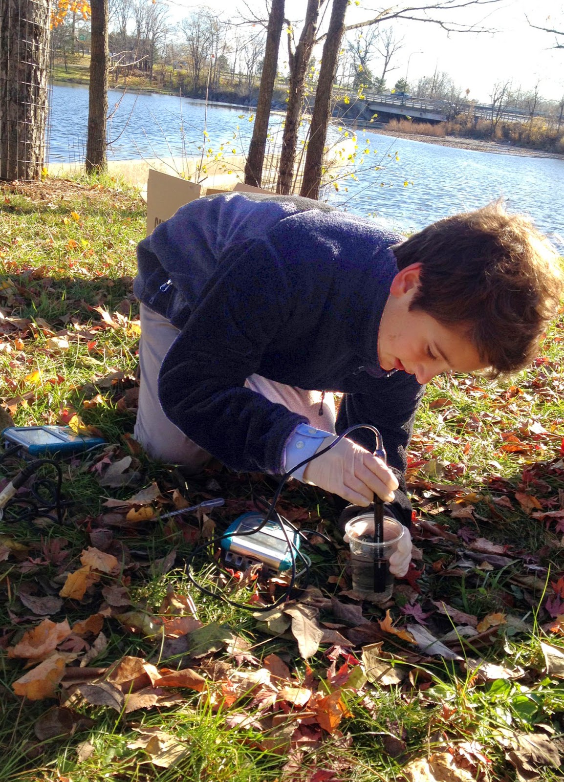.JPG) A group of seventh graders in Buffalo, New York are gearing up for a different kind of science class. On Monday, students will take a break from their regular activities to video chat with Great Lakes scientists and discuss issues like water chemistry, food webs, and pollution. And after spending the fall monitoring water quality in their local rivers, they have a lot of questions.
A group of seventh graders in Buffalo, New York are gearing up for a different kind of science class. On Monday, students will take a break from their regular activities to video chat with Great Lakes scientists and discuss issues like water chemistry, food webs, and pollution. And after spending the fall monitoring water quality in their local rivers, they have a lot of questions.
It’s all part of a joint program with IISG and the EPA Great Lakes National Program Office that gives students a chance to collect data on water characteristics like dissolved oxygen, conductivity, and pH. The monitoring equipment is similar to the sensors used aboard the EPA research vessel Lake Guardian.
.JPG) The Nichols Middle School students have worked throughout the year on projects related to field work done in the fall, and they plan to collect new samples next week. But before they return to the field, they will “sit down” with EPA scientists Glenn Warren, Eric Osantowski, and Beth Hinchey Malloy.
The Nichols Middle School students have worked throughout the year on projects related to field work done in the fall, and they plan to collect new samples next week. But before they return to the field, they will “sit down” with EPA scientists Glenn Warren, Eric Osantowski, and Beth Hinchey Malloy.
Each of the three classes will have roughly 20 minutes to ask questions about their fall data, the connections between different water characteristics, and the impact of human activities on Great Lakes health. They will also have a chance to talk about the ins and outs of being an aquatic scientist and the education those careers require.
Sandy Cunningham, the students’ teacher, has used the Hydrolab for several years and is one of three teachers to participate in the IISG-hosted video chats this year. Superior Middle School’s Stephanie Francis and Lesley Zylstra, a fifth grade teacher in Milwaukee, also used the monitoring equipment and conversations with scientists to boost their aquatic science sections. All three were introduced to the program, along with other classroom resources, during workshops coordinated by IISG.
Monday’s is the last videocast before summer break, but IISG’s Kristin TePas hopes to continue the event next year, each month with a different teacher.
*Students analyze water samples from local streams. Photos courtesy of Sandy Cunningham.
April 28th, 2014 by iisg_superadmin
Asian carp may be getting a foothold in waters near Lake Erie according to recent water sample analysis.
“Multiple water samples taken from the Muskingum River last fall carried the environmental signature of bighead carp, an invasive species threatening the ecosystem of the Great Lakes. A report released Friday by the Nature Conservancy — in conjunction with the Muskingum Watershed Conservancy District, the Ohio Department of Natural Resources, and researchers from Central Michigan University — indicated 10 of the 222 samples from the river tested positive for bighead carp eDNA.
Asian carp have been established in the Ohio River for more than a decade, but these eDNA results indicate the fish could be present in the Muskingum some 80 miles north of where the Muskingum joins the Ohio at Marietta.
The Muskingum has a series of old dams and deteriorating locks, but if the genetic evidence is accurate, those have not provided a significant impediment to the carp moving up the river system.”
Read more about the findings at the link above.
April 17th, 2014 by iisg_superadmin
With the big spring thaw underway (mostly) and warmer weather on the way, Lakes Michigan and Huron are on track to get closer to their long-term water levels than they were last summer.
“Water levels on Lake Michigan- Huron typically rise from March through July. Lake Michigan- Huron has risen one inch since early March, but is 13 inches higher than this same time last year. Although the above two lakes are higher, they are still 16 inches below the long term average for this date.
The rise in the lakes in the past month was the result of melting snow. Precipitation didn’t help much to the rise in lake levels, as March was fairly dry. The dry pattern in March was good for helping Michigan avoid major flooding. However, heavy rain would have really boosted lake water levels. March precipitation over the Lake Michigan-Huron drainage basin was only 1.49 inches, which was 69 percent of normal.”
Read more about the projected lake levels for this summer at the link above.
April 16th, 2014 by iisg_superadmin
Lake Erie is one of the Great Lakes that is most affected by toxic algal blooms, and finding the cause for them is the first step in reducing or preventing them. Scientists may be closer to understanding just what causes these harmful blooms.
“Algal blooms and dead zones in Lake Erie were severe during the 1960s, caused primarily by large releases of phosphorus from sewage and industrial plants. The 1972 federal Clean Water Act and the 1978 bi-national Great Lakes Water Quality Agreement led to dramatic reductions in phosphorus from these sources and a rapid improvement in water quality.
Lake Erie, however, saw a reemergence of the algal blooms and the growth of the dead zone in the mid-1990s, and the problems are worsening. In 2011, for example, Lake Erie experienced its most severe bloom of toxic algae on record. Last fall a toxic algal bloom in the lake forced officials to shut off a public water supply system in Ohio.
The new studies, part of the Ecological Forecasting (EcoFore) Lake Erie project led by researchers at the University of Michigan, found that the current targets to reduce phosphorus to alleviate algal blooms in Lake Erie may not be low enough to revive the dead zone. That conclusion informed the International Joint Commission’s recommendations in February for improving Lake Erie’s water quality.
The findings, and those of other studies from across the Great Lakes region, are delivering an ever clearer picture of the specific causes of nonpoint phosphorus runoff, algal blooms, and dead zones. The basic drivers of these problems are no longer unknown. The new research fills a critical void in information that has been often cited as a reason that strict regulations on nonpoint pollution sources, including agriculture, were not regulated under the 1972 federal Clean Water Act.”
Read the complete article and findings at the link above.
April 9th, 2014 by iisg_superadmin
Members of the House of Representatives from Great Lakes states are lobbying their colleagues in Congress to continue funding the Great Lakes Restoration Initiative.
“Forty-six House members from both parties recently sent a letter to leaders of a subcommittee that recommends spending on the environment.
It requests $300 million for the Great Lakes Restoration Initiative. The program usually gets about that much for projects dealing with threats such as toxic pollution and invasive species. President Barack Obama’s 2015 budget would cut it to $275 million.
Rep. Sander Levin of Michigan says the program has done much to improve the lakes’ health and now isn’t the time to cut back.”
Read more at the link above.
