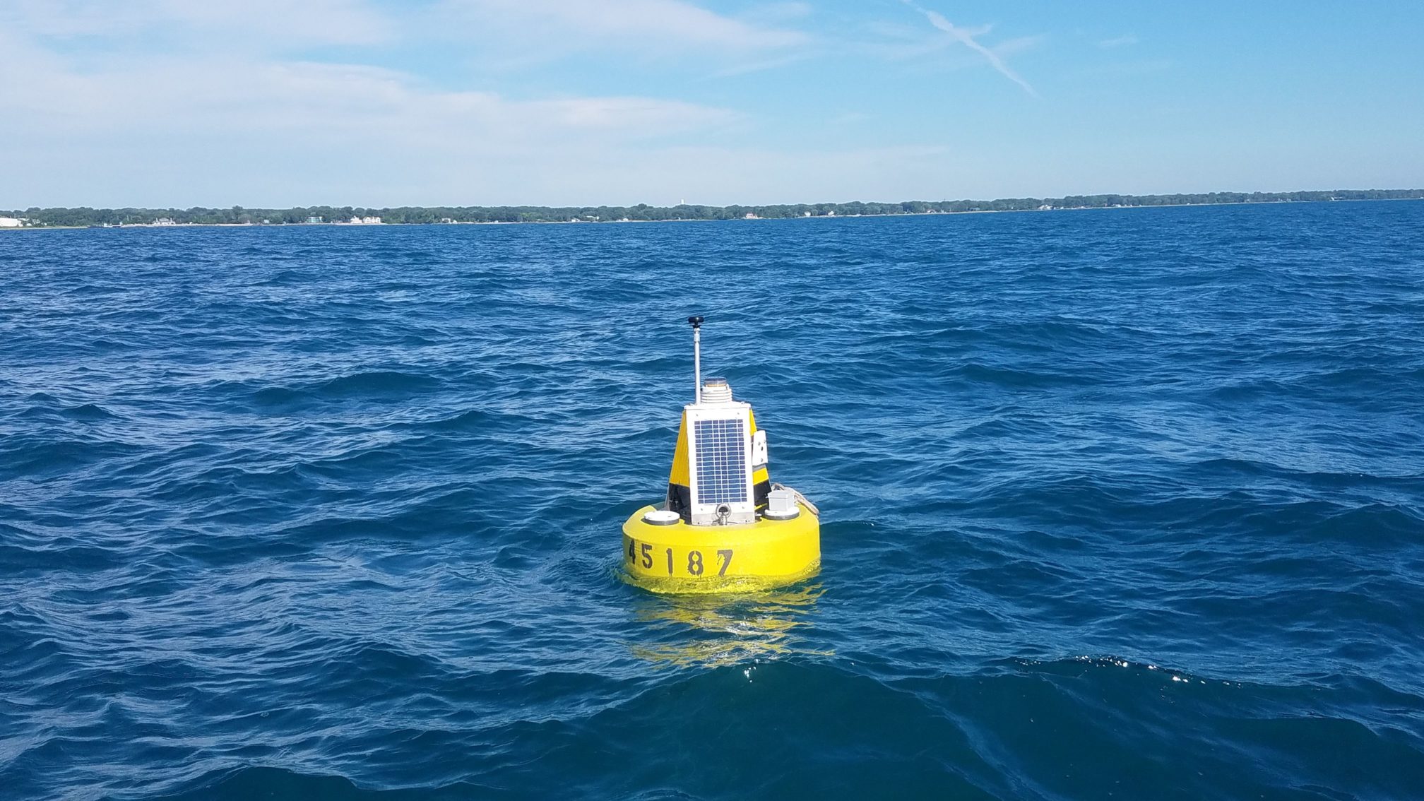
Lake Michigan now has two new buoys that monitor lake conditions in real-time. Placed about a mile offshore in Illinois waters—close to Waukegan and Winthrop Harbor—each buoy will measure air and water temperatures, wave and wind conditions, and water currents every 20 minutes while deployed. The buoys are also equipped with webcams that transmit an image and video once per hour during daylight hours. Illinois-Indiana Sea Grant will host the most recent data and images on their program website, while data will be managed by Great Lakes Observing System (GLOS).
Ethan Theuerkauf and colleagues from the Illinois State Geological Survey (Prairie Research Institute, University of Illinois at Urbana-Champaign) and the Illinois Department of Natural Resources Coastal Management Program have been working to deploy these buoys for several years. “We plan to use the buoy data to study the drivers of erosion along the Illinois shoreline,” said Theuerkauf, a scientist with the Illinois State Geological Survey and an adjunct professor at the University of Illinois at Chicago. “It is a bonus that so many boaters and swimmers can also use the information.”
“It’s great to have two more systems that will help scientists and weather forecasters understand what’s happening in the Illinois and Indiana waters of Lake Michigan,” said Jay Beugly, an aquatic ecology specialist with Illinois-Indiana Sea Grant, who helped place the buoys in the water on July 19 and is the main support for the Illinois-Indiana Sea Grant real-time buoy program.
Photo credit: Ed Verhamme, LimnoTech, Inc.
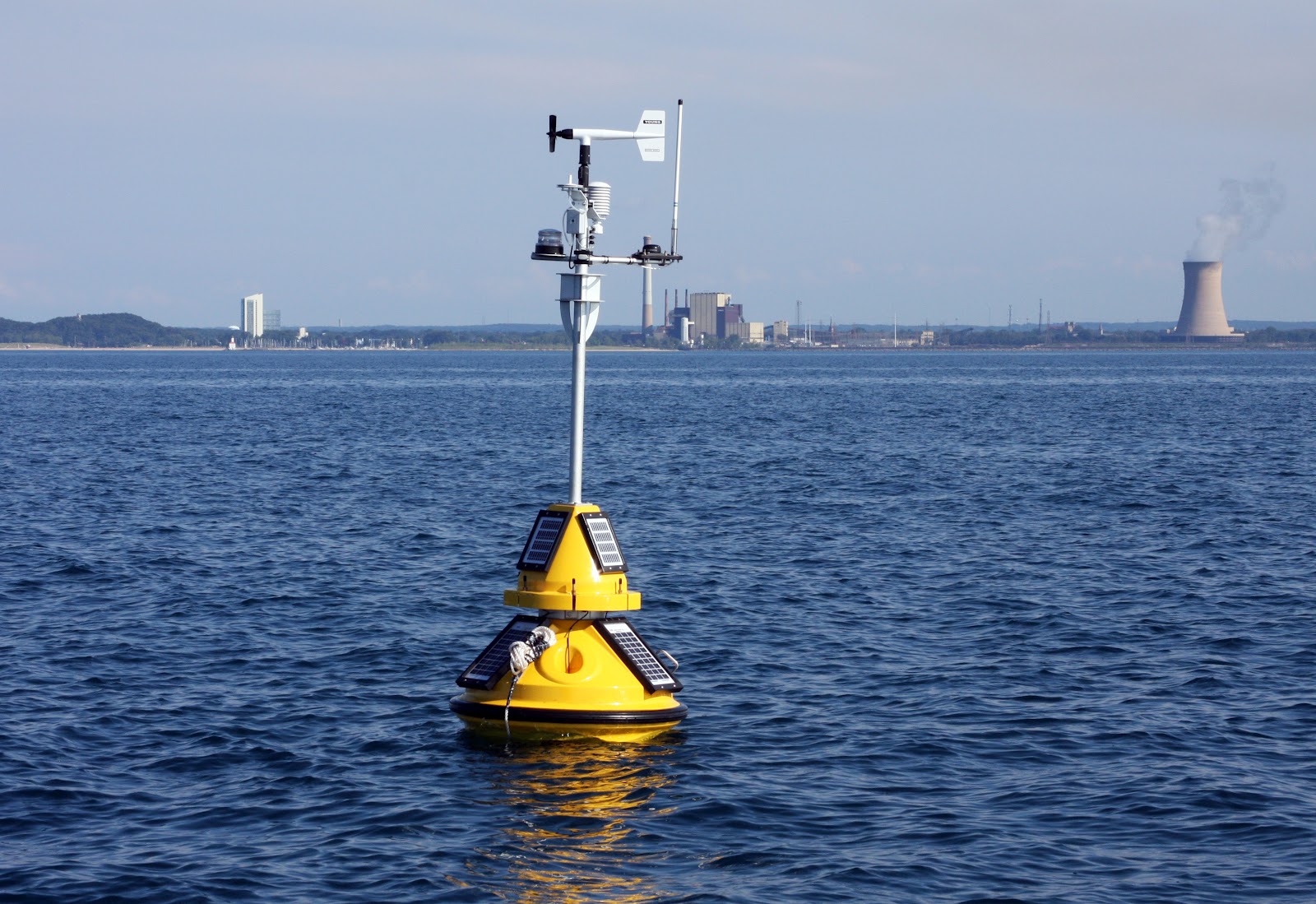
Ed Verhamme, a project engineer with LimnoTech, Inc., designed and custom-built these buoys for application along the Illinois shoreline. “These buoys are closer to shore than other buoys in Lake Michigan, which helps scientists better understand how waves and currents affect the shoreline, but also required us to use a different type of buoy”, said Verhamme who also joined Beugly and Theuerkauf during the buoy deployment.
As of July 23, 2018, data from the two new buoys can be found via the GLOS data portal and the National Data Buoy Center by searching buoy numbers 45186 (Waukegan) and 45187 (Winthrop Harbor). These buoys were supported by a NOAA Coastal Zone Management Projects of Special Merit Grant.
Our Michigan City buoy has a lot of sensors on it, but none are quite so popular as the temperature chain.
Every 10 minutes, 17 loggers, all at different depths, record and transmit the average water temperature of the lake.
Using data collected in 2016, Purdue University School of Civil Engineering student David Cannon visualized what happened in the top 45 feet of Lake Michigan, 3.5 miles northwest of Michigan City, Indiana.
The results shows just how variable the nearshore water is: one day it can be warm all the way to the bottom, and a week later it can be very cold way up at the surface.
For more information on buoys, winds, waves, and how they affect water temperature in nearshore Lake Michigan, see Lake Michigan By the Numbers.
Illinois-Indiana Sea Grant is a part of University of Illinois Extension and Purdue Extension.
The sun has set—literally, see above video—on another season for our Two Yellow Buoys anchored in Lake Michigan. Rest assured, they will be well-cared-for and back in action in the spring of 2017.
But if you can’t wait until next year to get your buoy fix, check #2YBHiatus on Twitter where there will be lots of data, discovery, and discussion!
1. The buoys are too delicate to withstand the Lake Michigan winter.
The main reason to take the buoys out is that the lake ices over in the winter and the delicate instruments that take measurements also need to be cleaned and maintained to be sure we can keep transmitting the best data possible.
2. It is much easier to retrieve the buoys at the end of the year than to put them out in the springtime. You usually need one person to captain the boat and 4-5 people to help pull up the ballast weights and stop the buoy from bouncing against the boat. Although this year, the buoys were giving our scientists a little trouble. Don’t worry, though. Everyone is safe and sound on dry land!
3. The buoys are usually stored at the Purdue University West Lafayette campus in the civil engineering building.
Sometimes they are stored at LimnoTech’s headquarters, in Ann Arbor, Michigan. The buoys tend to move around during the winter, especially if they need upgrades. So keep your eye out for buoys on trailers when you’re travelling down I-65 or I-94.
4. Every year scientists have to remove thousands of quagga mussels attached to the buoys.
Quagga mussel veligers—a mollusk larval stage—floating around Lake Michigan are always looking for hard structures to attach to. Though some of the surfaces on the buoys are smooth enough to stop the quaggas from attaching, they always manage to find their way into nooks and crannies. We carefully inspect the buoys before leaving the lakeside and remove anything we see, either manually or with help from a hose.
5. The buoys receive thorough maintenance.
The main hulls get washed off and all of the sensors are removed and cleaned. Depending on the sensor, this may mean an acid wash or just a good wipe down. One year, we had to replace a solar panel that had completely fallen off, so we’re always double-checking that everything is where it’s meant to be.
6. The buoys stop generating data, but all that’s been collected is ready and available online.
The IISG buoy data pages—dashboards and graphs—are not active when the buoys are not in the water. Historic data can always be found via the National Data Buoy Center (Michigan City 45170 , Wilmette 45174 ).
People who want to use the data should pay attention to notes like “Data have not been quality-checked.” Information marked with that tag may contain weird, fluke readings—like 100-foot waves! We try to do a quality check for the whole year of data within a few months of retrieving the buoy. People are also always welcome to email us to ask questions about the data.
Illinois-Indiana Sea Grant is a part of University of Illinois Extension and Purdue Extension.
Illinois-Indiana Sea Grant’s Wilmette buoy (45174) has been pitted against the City of Cleveland’s Cleveland Crib buoy (45176) in the World Series of Buoy Data. The match-up is playing out on Twitter. It’s a best of seven series and will last up to seven days. Questions are posted in the morning and answers are posted in the afternoon. After three days of competition, Wilmette is in the lead 2-1, winning both the highest wave and strongest wind gust recorded between July 1 and October 24 of this year. Cleveland saw the warmest water temperature.
The first thing IISG Assistant Research Coordinator Carolyn Foley does each morning is feed her kids. Then, while toast is toasting or oatmeal is warming up, she checks the IISG real-time buoys.
“Jayson Beugly, Angela Archer, and I all monitor the buoys to make sure they’re transmitting OK,” Foley said. “But I also look for cool things that are being captured.”
Foley shares these “cool things” via the @TwoYellowBuoys Twitter feed that was conceived during a 2015 IISG staff meeting.
“Jay and I were sitting next to each other during a talk about engaging with social media,” Foley recalled. “He turned to me and said, ‘We should make a Twitter account for the buoys.’ And we both began to laugh.”
Carolyn admits she didn’t know much about Twitter before starting @TwoYellowBuoys, but it seemed like a great platform for communicating the graphs and images constantly generated by the buoys.
“I think visually, and my favorite part of writing scientific manuscripts is putting together graphs in order to tell a story. I hope that seeing how the data illustrate trends and phenomena helps people better understand how scientists use the data to answer complex questions,” said Foley.
“And it doesn’t hurt that looking at the webcam pictures reminds me why I do what I do, especially when I haven’t been able to get near the water lately.”
IISG owns and operates two nearshore buoys in Lake Michigan, one in Michigan City, Indiana and another in Willmette, Illinois. The weather buoys serve a variety of audiences, from the National Weather Service to recreational water users. Data from the buoys, including information on water temperature, wind speed, wave height, solar radiation, and more, is transmitted every 10 minutes.
Foley is especially partial to posting thermocline data on Twitter because she knows anglers make decisions based on water temperature.
The buoy dashboards provide this data in both numerical and graphical form, and users can even access historic data. In addition, webcam images are captured every hour during daylight hours and shared online.
Using @TwoYellowBuoys, Foley has featured local and Lake Michigan-wide comparisons of water temperatures, air temperatures, wave heights, wind speeds, and more. She also pulls together images from the webcams atop the buoys to share with followers.
“It’s not up to us to predict what’s going to happen—the National Weather Service and others use the data for that purpose,” said Foley.
“But to be able to visualize what has happened and link it to real things that people have experienced, like storms or temperature shifts, is really fun and hopefully neat for people to see and understand.”
Not to worry. The Michigan City buoy is receiving first-class care and attention while it spends the off-season in a warehouse at Purdue. PhD candidate, David Cannon, pictured, is cleaning, charging, and repairing the buoy, readying it for its spring launch.
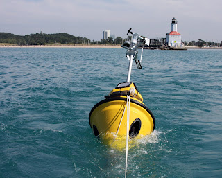
Swimmers, boaters, and anglers visiting Indiana’s coastline can once again learn about conditions in southern Lake Michigan with real-time data collected by the Michigan City buoy. The buoy, launched for the first time in 2012, returned to its post four miles from shore today to collect data on wave height and direction, wind speed, and air and surface water temperatures.
The only one of its kind in the Indiana waters of the lake, the Michigan City buoy and its temperature chain helps anglers and boaters find fishing hot spots and identify the safest times to be out on the lake.
Scientists at the National Weather Service in northern Indiana will also use wave height and frequency data collected throughout the season to better anticipate the locations of strong waves and currents that cause dangerous swimming conditions. Real-time data on nearshore temperatures and wave characteristics is also vital for research on fisheries and nearshore hydrodynamics.
Data will be available on IISG’s websiteuntil the buoy is pulled out for the winter in mid-October. The site shows snapshots of lake conditions—updated every 10 minutes—as well as trends over 24-hour and 5-day periods. Buoy-watchers can also download raw historical data at NOAA’s National Data Buoy Center.
And starting later this season, our website will also relay data collected by a new environmental sensing buoy placed north of Chicago. In addition to allowing people to track waves and temperatures, the data collected by this buoy could also help officials warn beachgoers when contamination levels may make swimming unsafe.
2014 has been an exciting year for IISG. New partnerships were forged, major projects were launched, and existing programs continued to grow. As we head towards another new year, let’s take a look back at some of the highlights of the last 12 months.
–More than $300,000 was awarded to three research projects that will improve understanding of the Lake Michigan nearshore food web, uncover connections between sediment removal projects and a community’s ability to weather environmental hazards, and identify why people adopt stormwater management practices.
–The Great Lakes Social Science Network gave researchers, natural resource managers, weather forecasters, and educators the information they need to ensure safety and planning messages meet the needs of local communities.
–A mobile app offering a self-guided walking tour of Chicago’s historic and scenic downtown shoreline was released for Android and iOS.
–We said goodbye to several staff members and friends and welcomed 10 more to the team.
–The Illinois Clean Marina Program celebrated one year and six certifications.
–We got some help spreading the word about AIS prevention from celebrity newcomers Lady Quagga and Jumpin’ Jack.
–The Michigan City buoy returned to the nearshore waters of Lake Michigan with a new sensor chain that measures temperatures at different depths.
–Illinois Governor Pat Quinn announced a $1.1 million investment in Blue Island to expand and improve stormwater management efforts that began in partnership with IISG.
–Great Lakes Monitoring made it possible for researchers to analyze decades of high-quality monitoring data from across the region in minutes.
–Illinois EPA and the state Department of Agriculture released a plan to reduce the nutrient pollution behind the Gulf ‘Dead Zone.’ A big thanks to all of the partners and collaborates that made these and other 2014 successes possible!
A new environmental sensing buoy will be placed north of Chicago this summer, making it easier than ever for Illinois boaters and beach-goers to spend a fun, safe day on the water.
Like its counterpart in Michigan City, IN, the nearshore buoy will relay information on wave height and direction, wind speed, and air and surface water temperatures in near real time. A webcam will also make it possible to watch changing lake conditions first-hand.
This is the newest in a string of nearshore buoys along the Lake Michigan shoreline. In addition to allowing people track waves and temperatures, the data they collect will help officials warn beachgoers when contamination levels may make swimming unsafe. Researchers also rely on the real-time information to manage fisheries, monitor lake currents, and improve hazardous weather predictions.
The Illinois buoy, jointly operated by IISG and LimnoTech, is expected to go online in May. The project is funded by the Great Lakes Observing System through a grant from NOAA Coastal Storms.
Meet IISG grad student scholar, Dohyung Bang! Dohyung is a PhD candidate in the White Lodging-J.W. Marriott, Jr. School of Hospitality and Tourism Management (@purduehtmlife) program at Purdue University. He is studying how complex tourism systems shape societal and economic outcomes. His project, funded by IISG, examines the impact of the home-sharing economy on housing market dynamics in the Lake Michigan area.
Photo 1: photo of Dohyung Bang Photo 2: A map illustrating short-term rental distribution in the Chicago area. Photo 3: Dohyung Bang presents his research at the 31st Annual Graduate Education and Graduate Student Research Conference in Hospitality and Tourism
Learn more about Dohyung’s work at the link in bio.
Interested in becoming an IISG grad student scholar? Learn more: https://iiseagrant.org/its-time-to-apply-for-the-2026-iisg-graduate-scholars-program/
Join the 2026 Great Lakes BioBlitz! 🌎🦋📸 Starting Earth Day, educators, students, youth groups, and families are invited to help document biodiversity across the Great Lakes region using iNaturalist. A kick-off webinar is scheduled for April 16th at 2 pm CT. Participate anytime during the four‑week event. Snap photos, make observations, and contribute to real conservation data while getting students outside and engaged with nature.
Learn more and get ready to explore: https://sites.google.com/wisc.edu/annual-great-lakes-bioblitz/2026
Don’t miss out! Join us for a deep dive into the latest Lake Michigan fisheries science.
Topics will include: -Reef restoration impacts on aquatic and fish species -Wild reproduction rates for salmon and trout species from the Great Lakes Mass Marking Program -Fisheries update from the Illinois Department of Natural Resources
Learn more & register: https://purdue.ca1.qualtrics.com/jfe/form/SV_86eBlPnbjdm7pPg
Celebrate Earth Day with freshwater science and good conversation! Join Illinois-Indiana Sea Grant, the Northwestern Center for Water, Loyola University researcher Tim Hoellein, and IISG’s Sarah Zack for Science Sips: Trash Talk about Chicago Waterways. Learn what research reveals about litter and trash in Lake Michigan and Chicago waterways and what we can do to help. Plus, enjoy Great Lakes trivia games!
📅 April 22, 2026 ⏰ 7–9 PM 📍 Sketchbook Brewing Company, Evanston Tap Room
Come curious and ready to test your Great Lakes knowledge!


