Topic: Climate Ready Communities

Sort By: Alphabetical | Newest | Oldest

What is a Meteotsunami? Meterological Tsunami: A Tsunami-Like Wave Caused by Weather Systems Thumbnail
File Type: pdf
File Size: 934.67 KB

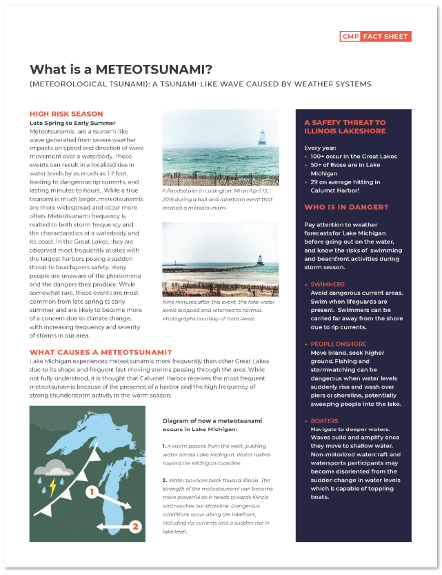
Meteotsunamis are a tsunami-like wave generated from severe weather impacts on speed and direction of wave movement over a waterbody. These events can result in a localized rise in water levels by as much as 1-2 feet, leading to dangerous rip currents, and lasting minutes to hours. While a true tsunami is much larger, meteotsunamis are more widespread and occur more often. Meteotsunami frequency is realted to both storm frequency and the charactaristics of a waterbody and its coast. In the Great Lakes, they are observed most frequently at sites with the largest harbors posing a sudden threat to beachgoers safety. Many people are unaware of the phenomena and the dangers they produce. While somewhat rare, these events are most common from late spring to early summer and are likely to become more of a concern due to climate change, with increasing frequency and severity of storms in the Great Lakes region.

Download File

Virtual Lake Levels Workshop Report Thumbnail
File Type: pdf
File Size: 773.78 KB

Summary report for IISG’s virtual workshop that was held in October 2020 and focused on improving communication about changing lake levels and water level variability in southwestern Lake Michigan and the impacts to the Chicago metropolitan area.

Download File

Type E Botulism Outbreaks: A Manual for Beach Managers and the Public Thumbnail
File Type: pdf
File Size: 4.91 MB

This manual, prepared by the Great Lakes Regional Collaboration (GLRC), provides information regarding Type E botulism and how to control its spread throughout the region. It is intended to provide both beach managers and the general public with guidance on Type E botulism and to provide sources of additional information.

Download File

Tipping Point Planner Curriculum Thumbnail
File Type:
File Size:

Through the decision support system, Tipping Point Planner (tippingpointplanner.org), communities in Great Lakes states can plan for a sustainable future by directly linking data to the local decision-making process. With help from trained facilitators, Tipping Point Planner enables professional as well as citizen participation in the land use planning and management process, including maintaining projects using a HUC 12 watershed scale. The program provides information, tools, and resources to help communities work with diverse stakeholders to:

  • Examine past and predicted land-use changes
  • Identify environmental threats
  • Define natural resource assets in need of protection or restoration
  • Explore land-use strategies and policies that enhance local values
  • Gain the framework to define a community’s priorities through interactive community visioning exercises

The curriculum contains education materials and resources to support community planning for land use and natural resource management. The following curriculum chapters are available for download:

  • Tipping Point Planner Introduction
  • Planning Tools for Land Use and Natural Resource Management
  • Tipping Point Planner Modules

To learn more about facilitated community action planning program offerings, please visit www.purdue.edu/fnr/extension/scep/programs/tipping-point-planner

To download this resource visit the Purdue Extension EdStore at https://mdc.itap.purdue.edu/item.asp?Item_Number=ID-514-TPP.

Download File

The Helm Winter 2013 Thumbnail
File Type: pdf
File Size: 677.13 KB

Feature Headlines

  • Forecast Calls for Windy City Winter Blues
  • Invasive Mussel Impacts: It’s Complicated
  • Nearshore Food Web is an East-west Story
  • Student Scientists Explore Real-world Issues
  • New Tool Helps Planners Steer Clear of Tipping Points
Download File

The Helm Spring 2016 Thumbnail
File Type: pdf
File Size: 2.42 MB

Feature Headlines

  • Peoria Stormwater Issue Reaches a Tipping Point
  • Rain Barrel Use Connected to Benefits
  • Stormwater Troopers go Green
  • Crude Oil Transport Brings the Great lakes risks and Benefits
  • Sea Grant Takes AIM in the War on AIS
  • Students Connect with Real-time Buoy Data
Download File

The Helm Fall 2015 Thumbnail
File Type: pdf
File Size: 3.44 MB

Feature Headlines

  • Indiana Seafood: Coming to a Restaurant Near You
  • Cook County Critical Facilities have New Tool to Reduce Flood Impacts
  • The Grand Cal Keeps Getting Better
  • Medicines in Lake Michigan Impact Minnow Embryos
  • New Research Projects Address Pollutants and Other Key Issues
  • The Medicine Chest has a New Look and New Lessons
Download File

Skip to content