August 12th, 2014 by iisg_superadmin
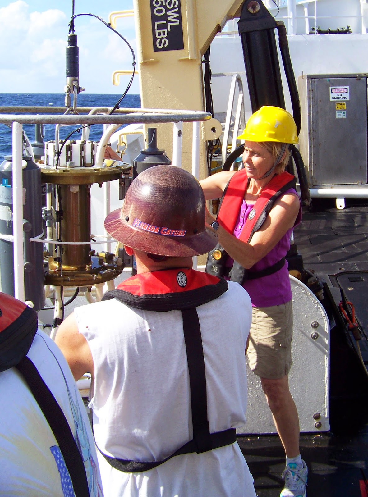
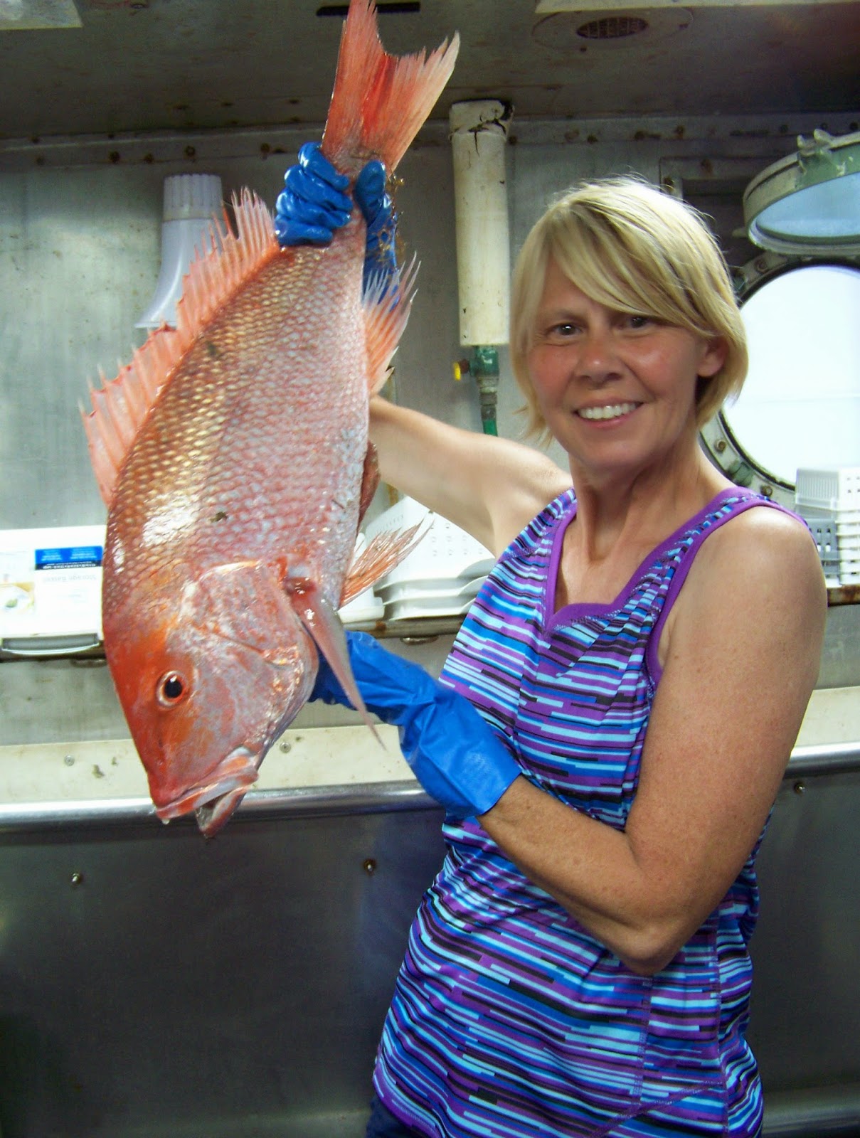
Illinois teacher Carol Schnaiter has big plans for her classes at Amboy Central School. Carol was one of 14 teachers to participate in IISG’s B-WET workshop last year. And this summer, she spent two weeks in the Gulf of Mexico aboard the NOAA research vessel Oregon II. Carol wrote in to tell us about her experiences at both, how they have already shaped her curriculum, and what she has planned for her students this year.
“I am constantly looking for workshops, classes, and events that I can attend and bring what I learned back to my class. Each adventure adds to our classroom and allows the students to learn something new.
 I was very excited when I was selected for the B-WET workshop in June of 2013. After the workshop, I added an entire unit on invasive species in the Great Lakes area for the 4th graders and another unit on restoration for the 3rd graders, plus I expanded the watershed unit I was teaching to the third graders. At the end of the units, I invited a guest speaker from the Amboy Marsh, Greg Hunter, to speak to all my classes about the Amboy Marsh and invasive species in our area. We then went to the Amboy Marsh, where the students pulled the invasive Garlic Mustard plant and cleaned away brush. The staff also arranged for guest speakers to talk about turtles, birds, and plants and gave a walking tour of the marsh. My colleagues and I are hoping to continue working with Amboy Marsh when we do our invasive species unit and our restoration unit each year.
 The students loved learning about the invasive species! We used the cards from the Sea Grant curricula and played games, such as Beat the Barriers. The students also did research on the various species and used the watch cards. When Mr. Hunter came in to speak, the students had background information on invasive species and were able to connect with what he was discussing.
This summer, I took part in the NOAA Teacher at Sea Program in the Gulf of Mexico. While on the ship, I worked with NOAA scientists and the crew to learn about the Gulf ecosystems first-hand and watch real science in action. I was on the midnight-to-noon shift for 16 days. We traveled to “stations” across the Gulf where we dropped the trawling net, the bongo nets, and the CTD (conductivity, temperature, and depth) sensors as part of the Groundfish Survey. Once the nets were brought up, we would count, measure, weigh, and record the sex of all the species. Our main objective was to collect information and send it to federal agencies that used it to set the shrimp season and catch limits.
 As a result of this experience, I am working on adding more information to our invasive species unit and creating another unit that will have the students trace the water from the Great Lakes watershed to the Gulf of Mexico. We will be following the NOAA Ship Oregon II as they go out for the fall Groundfish Survey and adding that information to the data collected while I was aboard this summer. We will be watching the water’s oxygen levels as the ship travels across the Gulf and will try to figure out what might be the cause of any changes.
Tying both the B-WET workshop and my experience on a working research ship together will allow the students to see how everyday science is touching our lives.”
August 6th, 2014 by iisg_superadmin
Steve Mauro’s research into the impacts of pharmaceutical and personal care products (PPCPs) on bacterial communities may have started as a small side project, but it has become so much more. The Gannon University dean gained national attention in 2011 when he and his research team discovered that small concentrations of fluoxetine are killing E. coli in the nearshore waters of Lake Erie. Today, Mauro continues to investigate exactly where and how fluoxetine and other pharmaceutical chemicals, both individually and combined, are changing the microbes that keep aquatic ecosystems healthy. And it is this work that brought IISG to his office bright and early on a June morning.
In this issue of UpClose, Mauro goes beyond his work on PPCPs to talk about the importance public outreach and about new efforts that are making it easier for forecasters and beach managers to predict when E. coli levels may make a trip to the beach more trouble than its worth.
August 5th, 2014 by iisg_superadmin
Believe it or not, Indiana is a prime location for aquaculture industries due to its rich supply of raw materials for fish food and access to large markets. And as fish continue to be harvested from oceans and other water bodies at unsustainable rates, the role of aquaculture grows ever more vital.
This work has led to economic development not just in the aquaculture industry but in a variety of other sectors as well. Research has revealed that farm sales of aquaculture products in Indiana reached about $15 million in 2013, a nearly five-fold increase over 2005. Fish farming in the state supports 280 jobs, 169 directly in the aquaculture industry. Aquaculture generates $3.7 million labor income and $19.5 million added value. The industry output is valued at $23.6 million for a total value of $38 million with other supporting industries.
To learn more about how IISG is empowering communities and individuals to strengthen local environments and economies, check out our 2013 program impacts.
August 4th, 2014 by iisg_superadmin
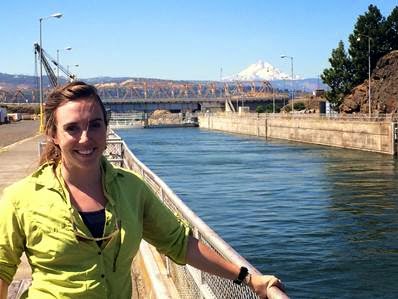
It’s been a few months since IISG-sponsored graduate students Sara Paver and Katherine Touzinsky began their Knauss fellowships. We were curious to hear about their experiences so far and thought you might be too. We heard from Sara a few weeks ago. This week we check-in with Katherine, an alum of Purdue University who is spending the year with the US Army Corps of Engineers.
 “This year has been overwhelming, in a good way. I never thought I would find myself working for the US Army Corps of Engineers. That being said, I also can’t imagine a better fit for my Knauss Fellowship. I went to Purdue University as a fellow in the Ecological Sciences and Engineering (ESE) interdisciplinary program because, as an ecologist, I thought it would be valuable to gain insight into the way engineers and other scientists think. In addition to the courses and thesis work I completed in the Forestry Department at Purdue, the supplementary education I received through ESE was eye opening and fascinating. I loved the practice of big-picture thinking, and this year with the Corps has solidified that love. It has prompted intellectual growth and self-realization. I’m moving on from studying human-ecological invasive species interaction to thinking about nationwide systems like marine transportation, flood risk management, and how to prepare for an uncertain future.
Living in Washington, D.C. has been an amazing experience in itself. Not only is my job exciting, but I moved out to D.C. with 50 other Knauss fellows—a built-in network of brilliant and ambitious people who have a true passion for the environment and for communicating science to those outside of academia. It has been so exciting and valuable to get to know the other fellows because I know they are people who will stay in my network the rest of my life. When else do you get to move to a new city with 50 new friends to explore it with?
In the past six months, I have spent a total of 11 weeks on the road—touring parts of our nation’s largest engineering projects that the public never sees, working on introducing new technologies to district projects, helping to facilitate workshops and conferences with environmentalists, regulatory personnel, and project directors from around the world, and learning about the staggering amount of resources and manpower involved in managing our waterway systems.
I am currently writing this post in a coffee shop outside of Portland, Oregon (yes, the coffee is great). I spent the past two days touring both the Bonneville Dam and The Dalles on the Columbia River with five engineers from the Engineering Research and Development Center. We worked with the dam operators on addressing some research and development (R&D) solutions to issues they have at their project sites—from fish ladders, to corrosion, to wear and tear from boats and barges coming in and out of the navigation locks. R&D can address all of these problems, and big-picture thinking while planning R&D projects is the key to a sustainable future. The Portland District projects were breathtaking—two of the largest power generating dams in the country.
August and September will bring trips to district projects in California and Hawaii and conferences in the Netherlands and Greece. I’m looking forward to what the next six months will bring. I truly can’t imagine a more exciting year.”
**Photo: Katherine standing near The Dalles navigation lock with Oregon’s Mt. Hood in the background.
August 1st, 2014 by iisg_superadmin
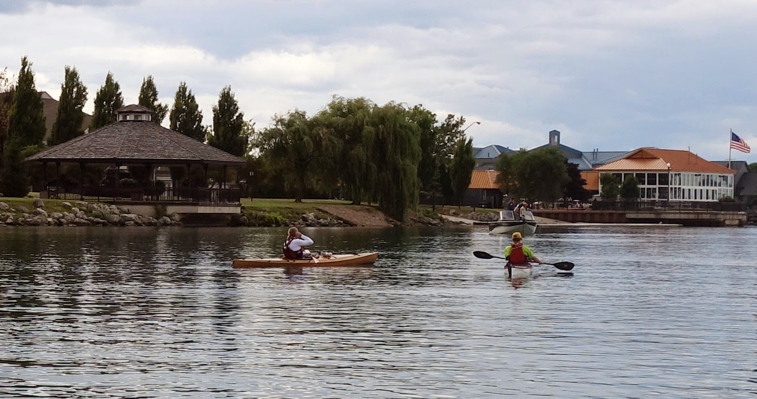
Earlier this week, a new environmental monitoring buoy joined a chain of similar buoys that are increasing boating and swimming safety and helping anglers target specific species of fish from Ludington, MI to Michigan City, IN.
From Michigan Live:
 Deployed roughly two miles off the shores of South Haven on Wednesday, the buoy can distribute improved wind and wave observations in addition to measuring wind speed, wind direction, air temperature, relative humidity, solar radiation, water temperature and wave height among other variables.
“Given South Haven’s strong connection to Lake Michigan I am excited for the addition of this station to the regional buoy network,” South Haven Mayor Robert Burr said in a statement. “The city’s goal is to provide area boaters, swimmers, and water safety professionals with up-to-date lake conditions. Conditions on the big lake can change fast and we want everyone to be prepared when venturing out on the water.
Click on the link above to read the complete article. And visit our buoy website to learn more about how real-time data is helping weather forecasters and researchers better understand the nearshore waters of Lake Michigan.
**Photo: Boaters and swimmers enjoy the water at South Haven Beach
July 31st, 2014 by iisg_superadmin
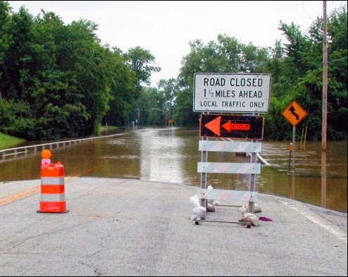
In July, the Taste of Chicago closed down for a day due to heavy rain. In the suburbs, storms are flooding streets and basements. It’s a rainy year—the month of June had the third highest rainfall at Chicago O’Hare since records have been kept in 1959.
City sewers built to take on storms from days gone by are no match for today’s rainfall that lands mostly on parking lots, streets, and sidewalks instead of being absorbed into fields and patches of forest. What’s more, climate change predictions appear to be coming true—larger storms are hitting more frequently.
Basements and streets underwater are a serious concern, but when Superstorm Sandy hit the east coast two years ago, it illustrated that flooding of critical facilities, such as hospitals, can have widespread and possibly catastrophic impacts.
IISG’s climate specialist, Molly Woloszyn, is tackling the issue of flooding from the angle of better preparation and prediction. She is part of a project that is assessing the flooding vulnerability of critical buildings in Chicago, including utility providers, transportation facilities, and hospitals. She is looking at factors like location, elevation, and flooding history of the facility, but also the placement of critical systems, such as generators and potable water supplies. Ultimately, this will result in recommendations on how these facilities can shore up their structures and systems to reduce this risk in the face of future storms.
Molly and other project contributors at the Midwestern Regional Climate Center are also dipping into 25 years of data from the Cook County Precipitation Network to connect large rain events with their consequences, such as combined sewer overflows and reports of basement and viaduct flooding. The goal here is to help the National Weather Service make forecasts that are impact-based for the city of Chicago.
Updating rain event reports for what constitutes a 5-year storm or a 100-year storm, for example, (meaning the probability of these storms happening is 1 in 5 or 1 in 100 years) is one part of the city’s plan for getting ahead of flooding concerns as detailed in the City of Chicago Green Stormwater Infrastructure Strategy. Planners and engineers use long term rainfall data to make decisions going forward, but the last report was released in 1992 with data up to the mid-80s. By all accounts, big storms are getting bigger and more frequent. More data is key for local decision makers. The Midwestern Regional Climate Center’s analysis of the Cook County data will provide new rainfall thresholds for various sized events over the course of the last 25 years.
July 30th, 2014 by iisg_superadmin
Jumpin’ Jack, the silver carp sensation known for his glam look and high-flying stage tricks, will join Lady Quagga on tour of schools and public events starting this month.
Despite differences in their history and style, the two have been dubbed a ‘captivating duo’ by many critics. Several experts have also commended the “spokes-mussel” and “flying fish” for dedicating their tour to spreading the word about the risks of
aquatic invasive species and how people can help prevent their spread.
Jumpin’ Jack, along with his cousin bighead carp, initially came to the U.S. in the 1970s to help control algae growth in aquaculture and municipal wastewater treatment plants. They soon moved to nearby lakes and rivers and are now a common sight on major rivers like the Illinois and Mississippi. Together, these Asian carp have knocked back plankton populations, crowded out native species, and seriously injured boaters.
In addition to traveling with Lady Quagga, Jumpin’ Jack is also booking independent appearances. Contact his manager,
Terri Hallesy, for more information.
July 28th, 2014 by iisg_superadmin
 Scientists and engineers are working together to design a clean-up plan for Michigan’s Upper Trenton Channel, where high concentrations of historic pollutants pose a threat to aquatic life and public health. The process began about a year ago with a feasibility study. In January, local residents had a chance to weigh-in on an early draft of the plan. And in the coming years, this Great Lakes Legacy Act project could remove or cap around 240,000 cubic yards of contaminated sediment.
Just as important as the clean-up effort itself, is ensuring that local communities and other key stakeholders understand the project and its goals. But before they can begin public outreach, project partners have to understand and appreciate the role the channel and nearby Detroit River play in the communities.
 That is where IISG’s social scientist Caitie McCoy and her interns Erika Lower and Mark Krupa come in. The three were in Michigan earlier this month to conduct a needs assessment that will help the project team tailor outreach products and messaging to those who use and visit the river.
They interviewed around 35 people with diverse backgrounds—everyone from area residents to city planners to members of boating associations—to learn more about their perceptions of the channel and river. The final results of the study won’t be available for a few months, but the interviews have already given Caitie, Erika, and Mark a better understanding of the interests and concerns surrounding this popular recreation site.
“One interesting thing we learned was that the safety of the channel and river during dredging is of prime importance to the community,” said Caitie. “This is a fast flowing channel, and we will need to explain the science and engineering behind what keeps stirred up sediment from flowing downstream during the project—in terms that everyone can understand.”
 An impromptu trip on the channel also gave Caitie, Erika, and Mark deeper insight into how the community uses the channel and river. The trip—which set off bright and early on the 16th—was led by the Wyandotte Rowing Club. Later that night, the group took to the water once again with one of the residents they interviewed.
Similar studies for the Sheboygan River and St. Louis River Areas of Concern have already helped shape outreach efforts there and allowed project partners to gauge changes in community perceptions at the end of a clean-up project.
The Upper Trenton Channel, which sits about 20 miles south of Detroit, is part of the Detroit River AOC. Project partners include Michigan Sea Grant, Friends of the Detroit River, the Detroit River Public Advisory Council, the Michigan Department of Environmental Quality, the Michigan Department of Community Health, and the U.S. EPA.
July 25th, 2014 by iisg_superadmin
This week Governor Pat Quinn signed the Clean Water Initiative, which will provide financial support for communities in Illinois to improve stormwater, wastewater, and drinking water infrastructure, and be better prepared to cope with the impacts of climate change – increased risk of drought and extreme precipitation.


