Alyssa Hausman, a master’s student in environmental science at Indiana University, shares her experiences as a Knauss Fellow at the U.S. Fish and Wildlife Service.
I have had great experiences working with the Knauss fellows in the past, so when I started graduate school in 2012, I knew that this fellowship was an opportunity that I couldn’t afford to not pursue.
After an extensive application process, I found out last June that I was a finalist for the 2015 fellowship class as an executive fellow. As one of 40 executive fellows, I had a wide-range of offices and positions that I could potentially be placed in. Executive fellows placements span a range of departments: Commerce, Interior, Navy, Energy, and independent agencies such as the EPA and National Science Foundation.
After a daunting placement week, complete with 15 back-to-back interviews, I was placed with U.S. Fish and Wildlife Service — an agency dedicated to conserving fish, wildlife, and plants and their habitats. My fellowship with the Service’s Division of Congressional and Legislative Affairs provides me the opportunity to engage the legislative branch on important wildlife issues, and even work alongside Knauss fellows in the legislative branch. My work so far has focused on the Endangered Species Act, coastal resources, and wildlife, and sport fish restoration.
Throughout the course of the fellowship, I have been able to visit various Service assets, including Blackwater National Wildlife Refuge and the National Wildlife Repository. I recently spent a month in the Service’s regional office outside of Denver, Colo., which included a short trip to view conservation efforts in the Dakotas. These opportunities have taught me so much about the Service’s efforts on important issues that I do not work on directly, such as invasive species control, wildlife trafficking, and habitat conversion.
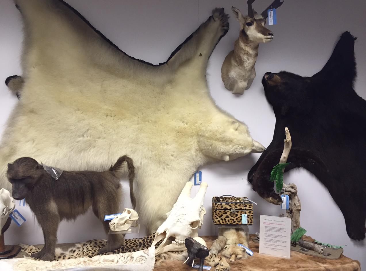
The National Wildlife Repository is responsible for receiving wildlife items that have been forfeited or abandoned to the U. S. Fish and Wildlife Service.
Now that I am half-way through my fellowship year and the next cohort of fellows has been selected, it is time for me to consider my next steps seriously. I have greatly enjoyed my time so far working with the Service and hope that I will have the opportunity to continue working with the agency, whether it be within the agency or outside as a partner.
Regardless of where I end up in February, I am looking forward to being a part of the Knauss alumni network and maintaining the personal and professional relationships that I’ve developed with my peers in the fellowship.
Boaters and beachgoers visiting the Chicago area this summer will have access to even more real-time data on lake conditions with a second nearshore environmental-sensing buoy that was launched in Lake Michigan on Tuesday, August 4, 2015.
The new buoy, located roughly four miles off the coast of Wilmette, Ill., relays information on wind speed, air and water temperature, wave height and direction, and other environmental characteristics from May to October each year.
Tom Palmisano, an owner of Henry’s Sports and Bait shop in Chicago, volunteered his boat and time to take out the anchor portion of the buoy.
“The buoy will be useful for anybody who does anything on the water,” said Palmisano, a longtime commercial and recreational diver.
The Sheridan Shore Yacht Club in Wilmette donated use of their crane to lift the hulking sections — totaling over 600 pounds — into the water.
The TIDAS 900 Wilmette buoy is a joint project between Illinois-Indiana Sea Grant (IISG) and LimnoTech to help advance understanding of nearshore waters, alert the public to hazardous conditions in real time, and improve weather forecasts. Staff from Purdue University Civil Engineering also assisted on the project. This one is also equipped with a webcam enabling people to actually see the conditions on the lake.
“This is a tremendous leap forward,” said Ed Fenelon, a National Weather Service (NWS) meteorologist with the Chicago office. “Before this buoy, there was a data void in almost all of the nearshore area.”
Data from the first buoy launched in 2012 off the coast of Michigan City, Ind., has already led to adjustments in wave forecast models and boosted understanding of fisheries and nearshore dynamics.
Data from the Wilmette buoy will also be used to improve predictions of hazardous weather conditions and issue swim and small water craft advisories.
“To accurately forecast the future, you have to have a detailed measurement of current conditions,” Fenelon added. “This buoy will give us just that.”
Current lake conditions will be updated every 10 minutes and be available at the IISG Wilmette Buoy page. The mobile-friendly sites highlight conditions of particular interest to recreational users, such as wave height, wind speed, and surface water temperature.
Along with graphs showing trends over recent time periods, this information will tell boaters and kayakers when it’s safe to be on the water and help anglers target specific species.
“We have talked with many different groups in the area, from anglers and boaters to scientists, and the response to the buoy has been overwhelmingly positive,” said Jay Beugly, IISG aquatic ecology specialist. “People are excited that this information is so easily accessible.”
The Wilmette buoy was funded through the Great Lakes Observing System (www.glos.us), which is part of the National Oceanic and Atmospheric Administration’s (NOAA) greater Integrated Oceanic Observing System network.
Information collected from the buoys is also fed into the National Data Buoy Center (http://www.ndbc.noaa.gov/) operated by the National Oceanic and Atmospheric Administration and the more localized http://greatlakesbuoys.org/. Forecasters, researchers, and others can download raw historical data for Michigan City buoy ID 45170 or Wilmette buoy ID 45174 from any of these websites.
The first thing I noticed when walking toward Bob and Nancy Larson’s house is the beautifully manicured centerpiece in his perfectly trimmed lawn. It’s hard to miss. The tall plants grab your attention long enough to realize that not everything is green. A closer look and little spots of color start to stand out. There is purple from the Joe Pye Weeds, yellow from the black-eyed Susan and light blue from the wild prairie petunias. The garden shines.
But this garden is more than a centerpiece. It is a tool.
When the Larson’s moved into their Champaign, Ill. home in 2009, they were excited to settle into their new neighborhood. However, just three days after they moved in, their basement flooded from the sanitary sewer backing up. It was then when Larson was made aware of the stormwater issues in his neighborhood. It also did not help that 2009 was the fifth wettest year on record since 1889. Seeing how having a flooded basement could become a continuous problem in the future, he decided to research ways he could prevent the buildup of water. That was when he discovered rain gardens. In conducting his research he became more and more interested in installing one of his own.
With the help of The Blue Thumb Guide, he started to design his own garden. He drew inspiration from designs he found in other books, online, and from visiting other gardens. When it was time to pick plants to place in his garden, he was drawn to native plants and made a conscious effort to seek those out. He visited nurseries to find the best plants for his garden, as well as using the book Native Plants in the Home Landscape for the Upper Midwest to organize his choices.
When it came time to start digging in his yard, Larson was optimistic, that is until he discovered there were layers of rocks under his soil. Even though this was an inconvenience for him, he patiently relocated the rocks and continued to carefully dig.
He placed the garden in the center of his front yard, to draw water away from his home. Blooming flowers on the outer part of the garden act almost as a lining. When in full bloom, there are many colors jumping out–they are very pronounced against the white of his house and really do act as a centerpiece in his lawn. In the center of the garden are plants with thicker stems as well as grass-like plants, such as purple coneflowers, sideoats grama, little bluestem, and big bluestem. This creates a very full yet manicured garden, yet the chaos that could happen with such a large array plants is contained.
Larson advises people to not over plant their garden as it can become more difficult to maintain a clean look, if that is what they want. He also stresses the importance of knowing the soil type. He has very fertile soil that drains well, so he chose not to add sand.
“I think it would have helped if I would have added sand to cut down on the fertility so stuff wouldn’t grow so big,” he said. “It’s kind of hard to do that afterwards.”
When installing a rain garden it is important to know what kind of garden your want, so even if you choose to do it on your own like Larson, it is still very manageable and attainable. -Victoria Figueroa
Illinois may be hundreds of miles from the Gulf of Mexico, but it’s a key contributor to the “dead zone,” a section of water the size of Connecticut devoid of oxygen that forms every summer. The culprit is millions of pounds of nutrients from farm fields, city streets and wastewater treatment plants entering the Gulf each year through the Mississippi River system.
The collaborative effort began almost two years ago in response to the federal 2008 Gulf of Mexico Action Plan, which calls for all 12 states in the Mississippi River Basin to develop plans to reduce nutrient losses to the Gulf. The process was spearheaded by the Illinois EPA and the Department of Agriculture and facilitated by Illinois Water Resources Center (IWRC) and Illinoi-Indiana Sea Grant (IISG).
“It’s the most comprehensive and integrated approach to nutrient loss reduction in the state’s history,” says Brian Miller, director of IISG and IWRC. “But what really sets the plan apart is how it was developed. Government agencies, agricultural producers and commodity groups, non-profit organizations, scientists, and wastewater treatment professionals were all at the table working together to create this strategy.”
The approach outlines a set of voluntary and mandatory practices for both urban and agricultural sources for reducing the primary drivers of the algal blooms that lower oxygen levels—phosphorus and nitrogen. By targeting the most critical areas and building on existing state and industry programs, these practices are expected to ultimately reduce the amount of nutrients reaching Illinois waterways by 45 percent.
Led by researchers at the University of Illinois, the study uncovered numerous cost-effective practices for reducing nutrient losses. At the heart of the strategy is a scientific assessment that used state and federal data to calculate Illinois’ current nutrient losses and determine where they’re coming from.
The plan for wastewater treatment plants is relatively straightforward. The state had already begun to cap the amount of phosphorus they are allowed to release, restrictions that will likely be expanded under the new plan. The strategy also calls for sewage plants to investigate new treatment technologies that could lower phosphorus levels enough to prevent algal blooms in nearby waterways.
For farmers and others working in agriculture, the options are a little broader. Most of the recommended practices, such as installing buffer strips along stream banks to filter runoff, planting cover crops to absorb nutrients and adjusting nitrogen-fertilizing practices have been used successfully in Illinois for years.
“There is no silver bullet for reducing nutrients,” said Mark David, a University of Illinois biogeochemist and one of the researchers behind the scientific assessment. “It is going to take at least one new management practice on every acre of agricultural land to meet the state’s reduction goals.”
Great Lakes Information Network awarded the July Site of the Month to GreatLakesMud.org. IISG created the site to disseminate information and provide resources to promote sediment cleanup and habitat restoration in Areas of Concern. The website was made possible by the Great Lakes Legacy Act, a program that, as of 2015, has cleaned up 2.9 million cubic yards of contaminated sediment through 17 remediation projects.
How does “green infrastructure” go from being just a good idea to actually being implemented in municipalities? At the recent Resilient Chicago workshop, we learned how this happens from a variety of perspectives.
Blue Island, Ill., a Chicago suburb with a growing problem with flooded basements, has become a leader in executing green infrastructure initiatives in recent years.
Jason Berry, deputy director of planning and building, described how at one point, even city engineers needed convincing that green infrastructure is not a “feel-good” project, but an effective and sustainable way to address stormwater issues.
Much of the city’s success is due to grant support from local, state, and even national sources. And, there is public involvement. As part of its Blue Island, Blue Water project, the city engaged many of its residents in installing rain barrels and planting rain gardens. The city is putting in permeable pavement, a bioswale, and numerous rain gardens.
“Green infrastructure is visible infrastructure,” explained Berry. “You can see it work.”
It also takes maintenance, which Berry described as a challenge for the city going forward.
Most communities will need to fund green infrastructure through limited municipal budgets, according to Josh Ellis, program director with the Metropolitan Planning Council. But he thinks green infrastructure has the possibly of becoming the new normal for infrastructure through “optimization.”
Optimization, as done by the City of Chicago, means maximizing investments through partnerships, leveraged funds, and multiple goals. Aaron Koch, deputy commissioner for sustainability, explained that the city has been employing green infrastructure for many years with green roofs and alleys, for instance. Now efforts are being planned more strategically.
For example, through the Space to Grow program, the city is partnering with Chicago Public Schools and nonprofits to “green” Chicago schoolyards. By planting rain gardens, and adding landscaping and playgrounds, students have a dryer, safer, greener, and more fun environment to play.
Argyle Street on Chicago’s north side is in the process of getting a facelift with porous pavement, planters, and trees that will go far to create community gathering spaces as well as enhance stormwater management. The Argyle Streetscape will be Chicago’s first “shared street” where pedestrians, cars, and bicycles will all co-exist in a curb-free world.
One way to normalize green infrastructure is to incorporate it into comprehensive planning. The Chicago Metropolitan Agency for Planning (CMAP) provides assistance for municipalities to do this.
According to Kate Evasic, associate planner, CMAP provides a process to collect data related to surface drainage, including historic conditions, topography, impervious cover, land use, and repetitive flood claims. And, the process provides the opportunities for shared solutions. CMAP has 50 projects underway right now.
-Irene Miles
(Photos from the Blue Island and the site design group, ltd. websites)
Ever wondered what it actually looks like as samples are collected from the floor of Lake Michigan? A science teacher from Elk Grove High School inIllinois got to the bottom of it for you.
When it came time to lower the multi-corer and hydraulic extruders, Quinn Loch strapped on a GoPro video camera to go for the 158-meter ride to the bottom.
Loch, along with 14 other educators, is working with 4 scientists as a part of the Shipboard Science Workshop aboard the U.S. EPA R/VLake Guardian.
The cores will be used to study dissolved oxygen and phosphorous levels in the water just above the cores.
The educators and scientists stand on the dock in Manitowoc, Wis.
Be sure to follow the educators on twitter at #lakeguardian and on the Teacher Features page on the CGLL website.
They will continue tweeting and blogging until the trip’s conclusion on July 18.
Heavy rain and flooding highlighted a wild month of June across central portions of the Midwest. Illinois was the wettest state, breaking a record that has stood for over 100 years. Illinois’ rainfall of 9.30 inches broke the record of 8.27 inches set back in 1902. This was more than twice the normal rainfall of 4.21 inches for the month. Indiana and Ohio also set June records with 8.90 inches and 8.13 inches, respectively. These states also saw more than twice their normal June rainfall and broke records that were set decades ago.
Chicago’s official station, O’Hare Airport, also reported more than double its normal precipitation with 7.12 inches. This was the 7th wettest June—the record is 9.96 inches set in 1993. Even though Chicago did not break its June precipitation record, it did break another—2015 now claims the cloudiest June on record with only 46 percent sunshine. The previous record low sunshine was 48 percent set back in 1942.
All of this rain has had its effect. Many crop fields are soaked, the rain stunting plant growth and preventing field chores. Lake levels continue to rise at record rates—more than 3 feet since January 2013. And NOAA is forecasting severe algal blooms in Lake Erie this summer.
Wetter-than-normal June’s have become a thing of recent years. In Illinois, four of the top 10 rainiest June’s on record have occurred since 2010 and for the Midwest as a whole, five of the top 10 rainiest June’s have occurred since 2000. The story isn’t much different in Chicago – five of the top 10 rainiest June’s at Chicago O’Hare have occurred since 2009.
With record-breaking June rain across portions of the Midwest and some of the wettest June months occurring in recent years, you may wonder if this is an indication what’s in store for the future. But, even though June has been wetter than normal in the past 10-15 years, the overall trend of climate data for the Midwest, Illinois, and Chicago do not show a statistically significant upward trend in June precipitation. In fact, three of the top 10 driest June’s on record in Chicago have occurred since 2003 and two in Illinois since 2005. It’s possible that the region is in a predominately wet pattern, which can last for a few decades or more, but it may not stick around for much longer than that. This is what happened in early part of the 20th century when drier-than-normal years were more common than wetter years.
Climate model projections show only slight increases in future total annual precipitation for the Midwest, particularly in the winter and spring (summer and fall precipitation are not expected to change much). However, larger increases are projected in the frequency and intensity of extreme precipitation across the entire region—meaning more precipitation may fall with each event (and longer dry spells in between) but the overall yearly total may not change much.
–Molly Woloszen, IISG and the Midwestern Regional Climate Center
Fifteen educators from six states surrounding the Great Lakes are getting the chance to be scientists in the field – or rather water – during this year’s Shipboard Science Workshop in Lake Michigan on the Lake Guardian, the U.S. EPA Great Lakes National Program Office (GLNPO) research vessel. The annual workshop will take place the week of July 12-18 and is hosted by Illinois-Indiana Sea Grant (IISG).
The teachers, alongside four research scientists from U.S. EPA GLNPO, University of Wisconsin-Milwaukee and Loyola University Chicago, will take part in sampling to evaluate the presence of microplastics and assess the impact of aquatic invasive species, especially zebra and quagga mussels.
And as part of the workshop, teachers will be able to analyze the samples in on-board laboratories. The hope is that the teachers will take their experiences back to the classroom and inspire their own students to want to do scientific exploration of the Great Lakes.
This workshop is IISG community outreach specialist Kristin TePas’ fifth, and she never tires of seeing teachers learning and researching in the field.
“Aside from the concept of educators working side by side with scientists collecting and analyzing data, these cruises have a lot of variation from year to year because the scientists change and thus the focus of research taking place is often different,” TePas said.
“I always look forward to watching how the educators take to the whole experience. They come on rather green and leave at the end of the week looking like they have always lived on the ship and working like a well-oiled machine with the field sampling and then analyzing in the lab.”
Bonnie Sansenbaugher, a teacher from last year’s workshop on Lake Erie, made sure she took advantage of the experience and didn’t return to her classroom empty-handed.
“As we were covering the curriculum portion of the workshop I was making notes of which lessons I will use for which class and which month I will cover that topic,” she wrote on the Center for Great Lakes Literacy blog.
On July 12, the ship will set sail from Milwaukee, with stops in Manitowoc, WI on the 14th, and Frankfort, MI on the 16th. This year, four educators from Illinois and two from Indiana will be making the trip.
Teachers will be tweeting and blogging on this cruise as well. Look for them on twitter at #lakeguardian and on the Teacher Features page on the CGLL website.
Each year a different lake within the world’s largest freshwater system goes under the microscope for this kind of intensive look-see. Next year it’s Lake Superior’s turn.
This workshop is funded through the Great Lakes Restoration Initiative. Wisconsin Sea Grant was a key partner in planning this year’s event.
Meet IISG grad student scholar, Wei Wu! Wei is a Ph.D. student at Purdue University focused on building AI-powered tools for coastal resilience. His research interests are combining drone sensing, 3D modeling, and immersive visualization to make environmental change more visible and measurable. Through IISG-supported research, he is advancing innovative approaches to monitor and strengthen communities along Southern Lake Michigan.
Full story at the link in bio.
Interested in becoming an IISG grad student scholar? Learn more: https://iiseagrant.org/its-time-to-apply-for-the-2026-iisg-graduate-scholars-program/
Don’t miss out! Join us for a deep dive into the latest Lake Michigan fisheries science.
Topics will include: -Reef restoration impacts on aquatic and fish species -Wild reproduction rates for salmon and trout species from the Great Lakes Mass Marking Program -Fisheries update from the Illinois Department of Natural Resources
With spring around the corner, are you curious how this year’s ice cover on Lake Michigan compares to past years? @noaa.glerl has got you covered with the data. Then you can borrow our Great Lakes Basin floor map to help students visualize the data.
View the data: https://www.glerl.noaa.gov/data/ice/
Request to borrow the map: https://iiseagrant.org/education/loanable-kits/
#TeachingTuesday #GreatLakes
Satellite Photo: February 12, 2023, MODIS satellite imagery indicates below-average ice cover on the Great Lakes for this time of year. (Credit: NOAA GLERL / NOAA Great Lakes CoastWatch Node)
Since January, we’ve been busy helping students and educators dive deeper into hands‑on science! This winter, our team supported community engagement at the Step N2 STEM event, the Annual HASTI Conference, at Decatur Classical School, and at the Chicago River Student Congress.
Educators and students joined us to: 🔍 Explored macroinvertebrates up close 🌊 Learned about watersheds through an interactive game 🔬 Investigated plankton under a microscope 🦠 Engineered and raced plankton in the Great Plankton Race


