July 9th, 2020 by Irene Miles
In Episode 13 of Illinois-Indiana Sea Grant’s podcast series Teach Me About the Great Lakes, titled “It Smells Like Science,” host Stuart Carlton interviews Brian Roth, an ecologist in the Department of Fisheries and Wildlife at Michigan State University. Roth studies food web structure and function to try to understand how fish management and harvest actions affects the food web and vice versa.

Brian Roth
Carlton, IISG assistant director, and Roth talk about predatory fish in the Great Lakes, the history of the Great Lakes salmon fishery, how native and invasive fishes interact within the ecosystem, and how the fish populations are changing as lake conditions change, as well. They also briefly discuss invasive crayfish and the nitty gritty detail of conducting a fish diet study.
Teach Me About the Great Lakes is a monthly podcast in which Carlton—a social scientist who grew up in the South near the Gulf of Mexico—asks people to explain the biology, ecology and natural history of the Great Lakes. A new episode is usually released on the first Monday of each month. The latest episode is embedded below.
Love this episode and want to hear more in the future? Subscribe on Apple Podcasts or Spotify, or use the RSS feed in your favorite podcast player.
If you have questions you want answered about the Great Lakes, reach out to Stuart Carlton at jsc@purdue.edu.
Illinois-Indiana Sea Grant is a part of University of Illinois Extension and Purdue Extension.
June 25th, 2020 by Irene Miles
Illinois-Indiana Sea Grant (IISG) announces the second group of researchers selected for the Sea Grant Faculty Scholars program. Established in 2019, the program seeks to help develop a community of scientists to work on critical issues related to Lake Michigan and the Great Lakes region.
“Through this program, we encourage researchers working in Illinois or Indiana to learn about issues facing our stakeholders,” said Tomas Höök, IISG director. “We provide funding and opportunity for one year. During this time, faculty scholars work with our stakeholders or program specialists to develop preliminary research products, but scholars must then develop and submit a larger proposal to another funding source to continue to address these issues.”
The inaugural faculty scholars cohort is wrapping up their projects. Karolina Kwasek of Southern Illinois University Carbondale is compiling knowledge from a variety of sources, including peer-reviewed literature and local fish farmers, to develop a protocol for raising young largemouth bass using indoor systems. (Kwasek was also funded for a related project.) Sundeep Inti of Purdue University Northwest is exploring the use of permeable concrete, which can allow water to pass through, as a way to address increased runoff due to larger storms and more urbanization. Finally, Max Melstrom from Loyola University Chicago examined recreational fishing license fees, including whether the amounts are fair and are optimal to encourage participation and meet budget needs. Melstrom is also working with the Great Lakes Aquaculture Collaborative, an effort to increase aquaculture production and sales in the region, assessing consumer values and willingness to pay for a variety of aquaculture products.
“The faculty scholar program provided the financial support and networking that has allowed me to do these projects,” said Melstrom. “I can say, without any hesitation, that being a part of this program has helped move my research program forward.”
The second group of faculty scholars began their projects on June 1, 2020. The new participants include William Bianco, a professor of political science at Indiana University, who will survey Indiana coastal communities to assess what steps they have taken in terms of climate readiness. Sophie Taddeo, a new researcher at the Chicago Botanic Garden and plant biology and conservation faculty member at Northwestern University, will use years of satellite data to help inform the restoration and management of Great Lakes coastal wetlands. And Pranshoo Solanki, an associate professor of civil engineering at Illinois State University, will take the first steps toward assessing the use of dredged material collected near Calumet Harbor as a substitute for sand in new construction material.
Höök looks forward to the future of the faculty scholars program. “We are excited to have a second cohort of faculty scholars. Our goal over time is to ensure the program grows and supports both the scholars and our stakeholder groups.”
Illinois-Indiana Sea Grant is a part of University of Illinois Extension and Purdue Extension.
Writer: Irene Miles, miles@illinois.edu
June 22nd, 2020 by Irene Miles
Over the past few decades, invasive species like zebra and quagga mussels have been eating up much of the base of Lake Michigan’s food web, affecting organisms throughout the lake, including alewife, a staple meal for salmon and trout. As menu options shift for these top predators, their success going forward may depend on expanding their diets.
A lake-wide study of salmon and trout conducted in 2015–16 found that diet flexibility varies among salmon and trout species, but Chinook salmon, the favorite of many anglers, are basically eating only alewife.
“This study describes how salmon and trout feeding patterns respond to the ever-changing Lake Michigan food web,” said Tomas Höök, Illinois-Indiana Sea Grant director. “Of particular concern, as alewife have been declining in abundance, the seeming inflexibility and continued reliance on alewife by Chinook salmon may not bode well for this highly prized species.”
Scientists from around the region got to the bottom of what five salmon and trout species in Lake Michigan eat in a direct way—they analyzed stomach contents. To do this on a lake-wide scale, they relied on help from the U.S. Fish and Wildlife Service (USFWS) and state Departments of Natural Resources around the lake. Agency creel survey clerks interviewed anglers and gathered data as well as fish stomachs. The Little Traverse Bay Bands of Odawa Indians also contributed from what they caught in their nets.
“It was a huge effort to accomplish something like this, so we needed help from just about everybody around the lake,” said Ben Leonhardt, who worked on this project as part of his Purdue University master’s degree and is now with the USFWS. “The anglers were the most important contributor—they took time out of their days to provide us with what we needed.”
The research team found that all five salmon and trout species ate alewife. But, unlike Chinook salmon, which almost exclusively consumed alewife, coho salmon also ate aquatic invertebrates. Lake trout and brown trout were less reliant on alewife, adding round goby to their diets, while rainbow trout also ate insects.
The story can get more complicated when factoring in location and season. “In the spring and only in the southeast portion of the lake, coho salmon were full of mysis,” said Leonhardt. “Anglers have noticed this at that time of the year, but it’s never been documented before.” Mysis, also known as opossum shrimp, is a tiny crustacean.
Also in the spring, along the Michigan side of the lake, brown trout and lake trout ate more round goby than alewife, but on the westside it was the opposite—brown and lake trout ate more alewife than round goby. One likely explanation for that difference is terrain. The gobies are able to hide on the rocky westside, but the sandy eastside offers no cover.
While alewife and round goby, both non-native species, were the prey fish of choice for salmon and trout, other fish like bloater or sculpin were also available and sometimes in greater abundance. Nonetheless, researchers rarely found these native species in the predators’ diets.
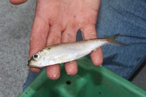
Alewife is a type of herring. (NOAA Great Lakes Environmental Research Laboratory)
One explanation for the salmon’s preference for alewife could be their silvery appearance. “Salmon are really interested in shiny objects—they’re really distracted by them,” said Austin Happel, a research biologist with Shedd Aquarium who has continued to be involved in this project since his tenure as a University of Illinois doctoral student.
Most of Lake Michigan’s salmon and trout species are non-native too, and they all have been stocked into the lake going back many decades. Understanding what these fish are eating and keeping predators and prey in balance is critical to maintaining a healthy fishery.
“Previous to this study, for coho salmon, brown trout and rainbow trout, resource managers have used diet compositions from the 1980s,” said Happel. “Now we know those species are not only eating alewife anymore. They’re also eating quite a bit of terrestrial insects and round goby. This can be included into stocking models to get a more complete prediction of how many fish—salmon and trout of different species—that the lake can handle.”
This project was the first part of a larger diet study assessing salmon and trout diets using three methods that assess diets at different timescales. This piece of the study, analyzing stomach contents, indicates what fish ate the day they were caught or maybe the day before. Second is to look at fatty acids in the fish, which show a longer time frame—what the fish ate over several weeks. The final piece is analyzing stable isotope ratios in fish tissues, revealing several months of a fish’s diet.
“Understanding changes in the Great Lakes ecosystem through solid scientific studies, such as the work by this team, is pivotal to inform fishery managers in their decision making,” said Tammy Newcomb, Michigan Department of Natural Resources senior water policy advisor and co-chair of the Great Lakes Fishery Trust Science Advisory Team.
The research was funded by Illinois-Indiana Sea Grant, the Great Lakes Fishery Trust and the Great Lakes Restoration Initiative. “Diet complexity of Lake Michigan Salmonines: 2015–2016” is available in the Journal of Great Lakes Research online now, and in the August print edition.
Illinois-Indiana Sea Grant is a part of University of Illinois Extension and Purdue Extension.
Writer: Irene Miles, miles@illinois.edu
May 29th, 2020 by Irene Miles
For the aquaculture industry in the Midwest to grow to meet the region’s seafood demand, some production hurdles need to be removed—one is the difficulty of feeding some newly- and recently-hatched larval fish indoors. An innovative approach, developed through Illinois-Indiana Sea Grant-funded research, shows promise for robust and healthy larvae as well as a potential new market for invasive Asian carp.
In aquaculture production, growing young larvae into fingerlings (or juvenile fish) mostly takes place in outdoor ponds. With many fish—including largemouth bass—when their eggs hatch, the tiny larvae have limited vision and mobility and primitive digestive systems. Young larval fish depend on live food, due, in part, to its nutrient availability and because they can see it moving when it swims by. But, with the food supply being unpredictable, temperatures fluctuating, and predators looming, survival rates suffer.
On the other hand, indoor production offers some control over the environment, but providing live food indoors is costly and labor intensive.
“The option then, is to replace live food, which is palatable, very colorful and contrasts against the color of the tank, with a dry pellet that immediately sinks—the larval fish oftentimes do not even get a chance to ingest it,” said Karolina Kwasek, a fish physiologist at Southern Illinois University. “Also, because we know little about larval nutrition, the dry food has been designed for more mature fish. It is composed of very complex nutrients that fish in these young stages are unable to properly digest yet need for proper growth and development.”
To test her new feeding approach, Kwasek turned to bighead carp, one of the invasive Asian carp species that has come to dominate the waters of the Illinois River and pose a potential threat to the Great Lakes. Bighead carp have been previously tested as a fishmeal source for largemouth bass.
“We wanted to see if we could use the same fish muscle source to obtain a high-quality ingredient to feed the very young of largemouth bass,” said Kwasek.
Here’s where the process is innovative—in the lab, the team used the digestive system of adult largemouth bass to break down the bighead carp muscle into simpler nutritional components so they would be readily available for larval fish. “The protein was completely digested to very small peptides or short chains of amino acids that were much more absorbable,” said Kwasek.
They tested the new food source, incorporating it into the diet of a larval largemouth bass sample, while another group had intact bighead carp muscle mixed into its diet.
The larval largemouth bass fed pre-digested bighead carp protein were larger in weight and length than those fed intact bighead carp muscle. “We think we achieved so much better growth performance because of much higher availability of these nutrients in these larval stages.”
Kwasek’s team also discovered some unexpected good news. They found that the occurrence of skeletal deformities was 17% lower in the group fed pre-digested food, which was at 6%, compared to the intact protein group at 23%. “We didn’t plan to look at deformities but as we started looking at these fish, it was obvious that the control group had so many more,” said Kwasek.
Illinois-Indiana Sea Grant is a part of University of Illinois Extension and Purdue Extension.
Writer: Irene Miles, miles@illinois.edu
April 14th, 2020 by Irene Miles
Population growth and industrial development, particularly in Chicago’s collar counties, has led to increasing groundwater withdrawals in the region. In some areas, groundwater is being withdrawn at a rate that exceeds the recharge rate, resulting in decreasing yields, increasing pumping demands, increasing salinity and the search for alternative water sources, all of which increase the cost of providing water to people.
“During the development of the region’s comprehensive plan, ON TO 2050, it became clear that critical water information that communities need to make informed land use, transportation, and infrastructure investment decisions was missing,” said Margaret Schneemann, Illinois-Indiana Sea Grant (IISG) water resource economist.
It was missing until now—IISG and the Chicago Metropolitan Agency for Planning have developed critical water demand and rate data for northeastern Illinois. The two products, available on the CMAP Data Hub, include past water use and demand forecasts and water and sewer rate data for each community utility.
Learn more about these datasets and how communities can use them on the CMAP website.
Illinois-Indiana Sea Grant is a part of University of Illinois Extension and Purdue Extension.
Writer: Irene Miles, 217.333.8055, miles@illinois.edu
Source: CMAP update Immerse Yourself in New Water Data
March 4th, 2020 by Irene Miles
Despite good intentions, many of us don’t necessarily change our behaviors to help protect the health of local waters. What would make the difference? Illinois-Indiana Sea Grant researchers combined social science and biophysical data to understand the likelihood that residents of northwest Indiana would implement practices that can be beneficial to water quality.
Among other findings, the research team found that people are more likely to adopt a conservation practice if it is something their friends or neighbors are doing.
Zhao Ma and Sara McMillan, both of Purdue University, focused their study on two Indiana watersheds that flow into Lake Michigan—the East Branch–Little Calumet River watershed and the Trail Creek watershed—quantifying pollution inputs and interviewing and surveying residents.
The research team divided the population into five groups that covered a range of urban, rural and agricultural landowners to assess each group’s contribution to local water pollution and learn about their willingness to adopt practices that might make a difference.
For each group, the scientists assessed ongoing nitrogen, phosphorus and sediment inputs as well as conservation practices already in place. These practices, also known as best management practices, are effective and practical approaches to reduce pollution and protect water quality, such as rain barrels and rain gardens in urban areas, and cover crops and conservation tillage in agricultural settings.
Overall, researchers found that participants were aware of water quality issues. “But what we’ve learned is that urban residents think farmers are the problem and farmers think urban residents are the problem” said Ma, a social scientist. “People tend to blame others.”
The study found that all five groups do, in fact, contribute to water pollution. The researchers also conducted a survey experiment by randomly including this information in some surveys to assess its impact on responses. But, when participants learned they are responsible for water pollution, this did not necessarily impact their willingness to adopt practices to reduce water pollution. Unless they already wanted to take action, survey respondents generally were unmoved by learning their contribution to local water pollution.
Providing general information on possible best management practices for improving water quality was not a key component for changing behaviors either, but it may provide a motivation for water resource professionals to engage in one-on-one discussions and explanations with residents.
“We learned that survey respondents didn’t necessarily have the knowledge or capacity to figure out if a conservation practice would work for them—this was a major barrier to action,” said Ma. “Residents knew what’s possible generally, but they wanted someone to help them decide what practices fit with their specific property and way of life.”
On the other hand, social norms are an important component in people’s decision making. Social norms include both descriptive norms—what you can observe in plain sight, such as your neighbors using rain barrels—and more subjective norms, for instance, what you think people expect of you.
The research team confirmed previous studies, demonstrating that people are socially driven. Generally, if we realize neighbors, friends and trusted peers are taking action, this makes us more likely to do something, too. Social norms can be a much bigger motivator to adopt conservation practices than information alone, and sometimes works better than other types of incentives.
For those interested in motivating residents, Ma suggests thinking about ways to capitalize on social norms. “Consider organizing community events or programming that encourages people to talk to each other—they become more aware of what others are doing and what is expected of them from their community,” she said. “Community role models and opinion leaders can also play an important role. The social aspect should be part of the solution strategy to protect water quality.”
The researchers have one more piece to this project. They are running different modeling scenarios to understand the realistic potential of using conservation practices to reduce water pollution in the watersheds. With that information, they will be able to further identify groups of residents to target for increased education, assistance and incentives to promote adoption of conservation practices.
You can listen to a podcast interview of Zhao Ma discussing this research in the first “Teach Me About the Great Lakes” Researcher Feature.
Illinois-Indiana Sea Grant is a part of University of Illinois Extension and Purdue Extension.
Writer: Irene Miles, 217.333.8055, miles@illinois.edu
February 27th, 2020 by Irene Miles
In northeastern Illinois, from 2008 to 2018, the average residential monthly water rate almost doubled. In fact, water costs are rising nationwide. If water rates continue to increase, economically vulnerable households may struggle to pay for this most basic necessity of life.
“Water utilities around the country increasingly need to balance their goals of recovering costs while keeping water flowing for those least able to pay,” said Margaret Schneemann, Illinois-Indiana Sea Grant (IISG) and University of Illinois Extension water resource economist.
IISG joined with the Metropolitan Planning Council (MPC) and Elevate Energy to better understand water affordability issues in northeastern Illinois and to help utilities find ways to address these issues in their communities. The team developed a new report, Water Affordability in Northeastern Illinois, which provides examples from states and municipalities around the country, illustrating a range of potential strategies and solutions.
The report has already proven helpful to the City of Chicago as it developed a new program to help low-income residents keep up with water bills. The Utility Billing Relief program, which begins March 1, 2020, provides reduced rates on water bills, eliminates late payment penalties and water shutoffs and provides debt relief for those who qualify. Predictions are that it will assist about 20,000 households in the city.
“Margaret Schneemann was part of the expert team that researched water affordability challenges and solutions in our region,” said Danielle Gallet, MPC director of water resources. “This work was instrumental to MPC’s efforts to provide useful and timely best practices to the City of Chicago during its creation of the Utility Billing Relief program.”
Water affordability is an increasing problem for several reasons—one major contributor is infrastructure. In many communities where infrastructure was built over a century ago, it is now in need of repair and replacement.
“Aging infrastructure drives up the cost of water service and creates challenges to supplying safe and reliable water service at a low price,” said Schneemann. “Also, water utilities are frequently playing catch up after years of deferred infrastructure investment.”
Income inequality also plays a role. Even when the average income in a community is not low, overall, income growth has largely been stagnant. The problem is made worse by segregation, which further contributes to income inequality across the northeastern Illinois region.
Because every community is unique, a one-size-fits-all water affordability solution does not exist. The report discusses five strategies that communities and utilities can adopt to address water affordability: reducing costs, improving water efficiency, designing affordable rates, establishing customer assistance programs and working to engage hard-to-reach customers.
Each of these strategies, designed to reduce the impacts of water bills on customers who are least able to pay, is explained through implementation considerations, potential recommendations and real-world examples.
This report is part of a larger initiative to research and explore the extent to which communities in the northeastern Illinois region are facing challenges to water affordability, and identify opportunities to address these concerns.
As part of this effort, the project team developed a suite of resources, including the Northeastern Illinois Water Affordability Dashboard, which is an easy-to-use resource for researchers, journalists and others looking for water affordability statistics broken down by municipalities in the Chicago area.
“As water rates increase and incomes remain stagnant, many households are struggling to pay their water bills,” said Caroline Pakenham, water program manager at Elevate Energy. “The Northeastern Illinois Water Affordability Study is an important first step to highlight growing issues of water affordability in our region and encourage dialogue around potential solutions.”
Illinois-Indiana Sea Grant is a part of University of Illinois Extension and Purdue Extension.
January 7th, 2020 by Irene Miles
Ever-present in our world, it’s not surprising that plastics have been found in waterways virtually everywhere, mostly showing up as microplastics. Another group of contaminants, PFAS (per- and polyfluoroalkyl substances) are, likewise, being detected in the environment across the globe.
All of these contaminants pose concerns on their own, but now research funded by Illinois-Indiana Sea Grant has found that PFAS can stick to microplastic particles in the water, increasing the likelihood that they will end up in the food web.
PFAS are human-made chemicals that are used in many common products such as non-stick cookware, pizza boxes and stain repellent fabric. Qualities that have made them useful—for example, they are very stable and are resistant to water and oil—can contribute to concerns about PFAS. They don’t easily break down in lakes, rivers, wildlife and people. PFAS can have health effects, such as increasing the risk of cancer, decreasing fertility, and impacting growth and learning in infants and children.
Plastics can break down in the environment to microscopic size or they can enter lakes and rivers as microplastics already—for example, as tiny fibers that wash off our clothing. Once in the environment and our waters, microplastics stick around, and like PFAS they do not easily biodegrade.
John Scott, an analytical chemist at the Illinois Sustainable Technology Center, led a team of researchers to understand the extent to which PFAS and other contaminants attach to microplastics in waterways.
His team used three common types of plastic, testing them in the waters of Muskegon Lake, which sits adjacent to Lake Michigan along the Michigan coast. They also did similar testing in a controlled environment using laboratory water.
Microplastic samples were submerged in the nearshore waters of the channel connecting the two lakes and in the middle of Muskegon Lake, for one month and three months in both locations, and in the laboratory for one month.
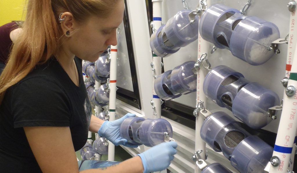
Rachel Orzechowski, a research assistant at AWRI, Grand Valley State University, sets up microplastics samples to submerge for 1-3 months in Muskegon Lake. (Photo courtesy John Scott)
The researchers found that regardless of location, length of time or type of plastic tested, PFAS in Muskegon Lake adhered to microplastic particles—ranging from .052 nanogram to .87 nanogram of PFAS for each gram of plastic. Interestingly, the amount of PFAS sticking to the microplastic in laboratory water was notably less.
“The difference may be due to associated organic matter or the presence of metals or biofilm, which is a collection of bacteria that grows on microplastic particles in the lake, making the surface easier to stick to,” said Scott. “This would also explain the wide variability that we found in PFAS concentrations on microplastic samples that were identical in substance and treatment. We did not find this degree of variability in the controlled experiments.”

Biofilm is a collection of microorganisms that grow on a variety of surfaces. (Graphic Joel Davenport/Illinois-Indiana Sea Grant)
Scott points out that the concentration of PFAS they found attached to microplastics in the study is quite low—for perspective, a nanogram is a billionth of a gram—but there is more to the story. “We submerged our samples for limited time, but some studies have estimated that half of microplastics in the environment have been there for 10 to 15 years. And many of these plastic particles in the water are smaller than we used in this study, so with similar mass they have more surface area, which could result in more adsorption.”
Another consideration is that PFAS are only one group of chemicals that can attach to microplastics. Scott said, “We don’t know the implications of what could be a cocktail of contaminants—like PCBs or PAHs—adhering to these particles and ingested by fish or other organisms.”
At the same time, many plastics may already contain additives such as heavy metals, flame retardants and plasticizers that can further exacerbate this issue. “These microplastics-associated pollutants can act synergistically when an organism is exposed to them,” said Scott.
Recent IISG-funded research at Loyola University has shown that fish in three Lake Michigan tributaries are ingesting microplastics. Biologists John Kelly and Tim Hoellein found that 85% of the fish tested contain, on average, 13 pieces of microplastic in their digestive tract.
Does this translate to a level of concern for fish regarding PFAS and other chemicals that may be in these waters and may be attached to microplastics?
“We just don’t know,” said Scott. “We don’t know if PFAS ingested on microplastics stay with the fish, we don’t know at what rate fish ingest microplastics and we don’t know what concentrations in fish are a cause for concern. This project highlights that, in addition to focusing on relevant microplastic concentrations, further studies need to consider environmentally exposed microplastics.”
Illinois-Indiana Sea Grant is a part of University of Illinois Extension and Purdue Extension.
Writer: Irene Miles, 217.333.8055, miles@illinois.edu
December 19th, 2019 by Irene Miles
As 2019 draws to a close, I’m pleased to report that here at Illinois-Indiana Sea Grant, we’ve had a very good year, and that remained the case through the latter months.
In October, IISG underwent its program site review, which takes place every four years. Through this process, we presented our work from our last omnibus as well as our current activities to the external site review team. The review provides a great opportunity to reflect on our accomplishments and to look forward to new efforts.
The review team was very positive in its response, which, in large part, is due to not only the hard work of the IISG team, but also the great amount of support from our diverse partners, many of whom directly participated in the review.
This fall, we expanded our communication tools and products to share information about the Great Lakes with wider audiences. Inspired by a rich collection of photographs taken by Peter Essick, who works with National Geographic, IISG led the development of a photo essay called Great Lakes Resurgence about Areas of Concern in the region. The Great Lakes Sea Grant Network collaborated to tell the stories of these degraded waterways, to describe the progress of cleanup efforts and report local impacts of coastal restoration.
IISG now has a monthly podcast series, Teach Me about the Great Lakes, which debuted in December. Hosted by Stuart Carlton, the program’s assistant director, the podcast helps Stuart—and listeners—learn about the biology, ecology and natural history of the Great Lakes. Stuart is a social scientist who grew up in the south, so he is fairly new to Great Lakes issues. The first installment dove into concerns about microplastics, which have been found in the Great Lakes and many waterways all over the world. The next episode, available in early January, will focus on the geological history of the Great Lakes.
Autumn also brought awards season for the Sea Grant program, both regionally and nationally. We are proud of Pollution Prevention Specialist Sarah Zack, who was honored with the Great Lakes Sea Grant Network Early Career Award at the regional meeting in Sault St. Marie, Michigan. Irene Miles, strategic communication coordinator, won the Communications Service Award at the Sea Grant Extension Assembly, Communicator and Research Coordinator Conference in Savannah, Georgia. Also at the Savannah meeting, Brian Miller, IISG’s former director, was selected for the William Q. Wick Visionary Career Leadership Award, one of Sea Grant’s most prestigious honors.
As we all look forward to 2020, we wish you the best in the new year. For IISG, 2020 will bring an even greater focus to Lake Michigan. Scientists from around the Great Lakes basin will converge on the lake to conduct intensive research through the Cooperative Science and Monitoring Initiative (CSMI). IISG has just released an ESRI story map, Lake Michigan Health: A Deeper Dive, to share the results from the 2015 CSMI field year on Lake Michigan.
The Shipboard Science Workshop will also take place on Lake Michigan in the coming year. During this week-long workshop on the EPA research vessel the Lake Guardian, organized through the Center for Great Lakes Literacy, teachers from the region work side by side with scientists to study one of the Great Lakes. This coming year they set sail on Lake Michigan. We look forward to new science and stories that will emerge from both of these exciting initiatives.
Tomas Höök
Director, Illinois-Indiana Sea Grant
Illinois-Indiana Sea Grant is a part of University of Illinois Extension and Purdue Extension.
