October 12th, 2012 by Irene Miles
The U.S. EPA recently awarded a Great Lakes Restoration Initiative grant to the Ozaukee Washington Land Trust to help them in their fight against some of the most common and invasive plant species that have taken hold in Wisconsin wetlands.
“This quest received a financial boost last week when the U.S. Environmental Protection Agency awarded a $448,663 Great Lakes Restoration Initiative grant to the Ozaukee Washington Land Trust. In return, the group and its partners will inventory and eliminate the most aggressive of invasive plants in wetlands and waterways in the six counties.
Graff, executive director of the land trust, said work will continue the rest of this year on locating each infestation. The organization is working with other land trusts in the region, the Wisconsin Land and Water Conservation Association and River Alliance of Wisconsin to curb the threat posed by the exotic plants.”
Follow the link above for the complete article, including information on other groups across seven Great Lakes states that received funds to help fight invasive species.
October 11th, 2012 by Irene Miles
Chicago area waters will be searched again beginning next week for indicators of Asian carp presence near Lake Michigan.
From WTAQ.com:
“Over 170 samples were taken from Chicago’s North Shore Channel from June through September – and 10-percent had the carp’s DNA. The same was true for 17 of 57 samples last month in the nearby Chicago River.
As a result, an actual search for the bloated carp will take place next Tuesday through Friday on the North Shore Channel and a six-mile stretch of the Chicago River west of the city.”
Read the complete article at the link above.
October 3rd, 2012 by Irene Miles
If you tuned in to “Off the Hook: Extreme Catches” this past Sunday on Animal Planet you got a chance to see Asian carp, a major aquatic invasive concern, as well as some people who are fighting the flying fish.
“The Animal Planet show that spent four days filming on and around the Illinois River last summer for a feature on the acrobatic insanity of everyone’s least favorite invasive fish, the Asian carp, will be shown Sunday.
“Off the Hook: Extreme Catches,” with host/professional wrestler Eric Young presents “Carpocalypse Now” at 7 p.m. Sunday. Greg Gephards, who owns Schooners on War Memorial Drive and had a role in the production of the program, is hosting a party for the occasion.”
October 2nd, 2012 by Irene Miles
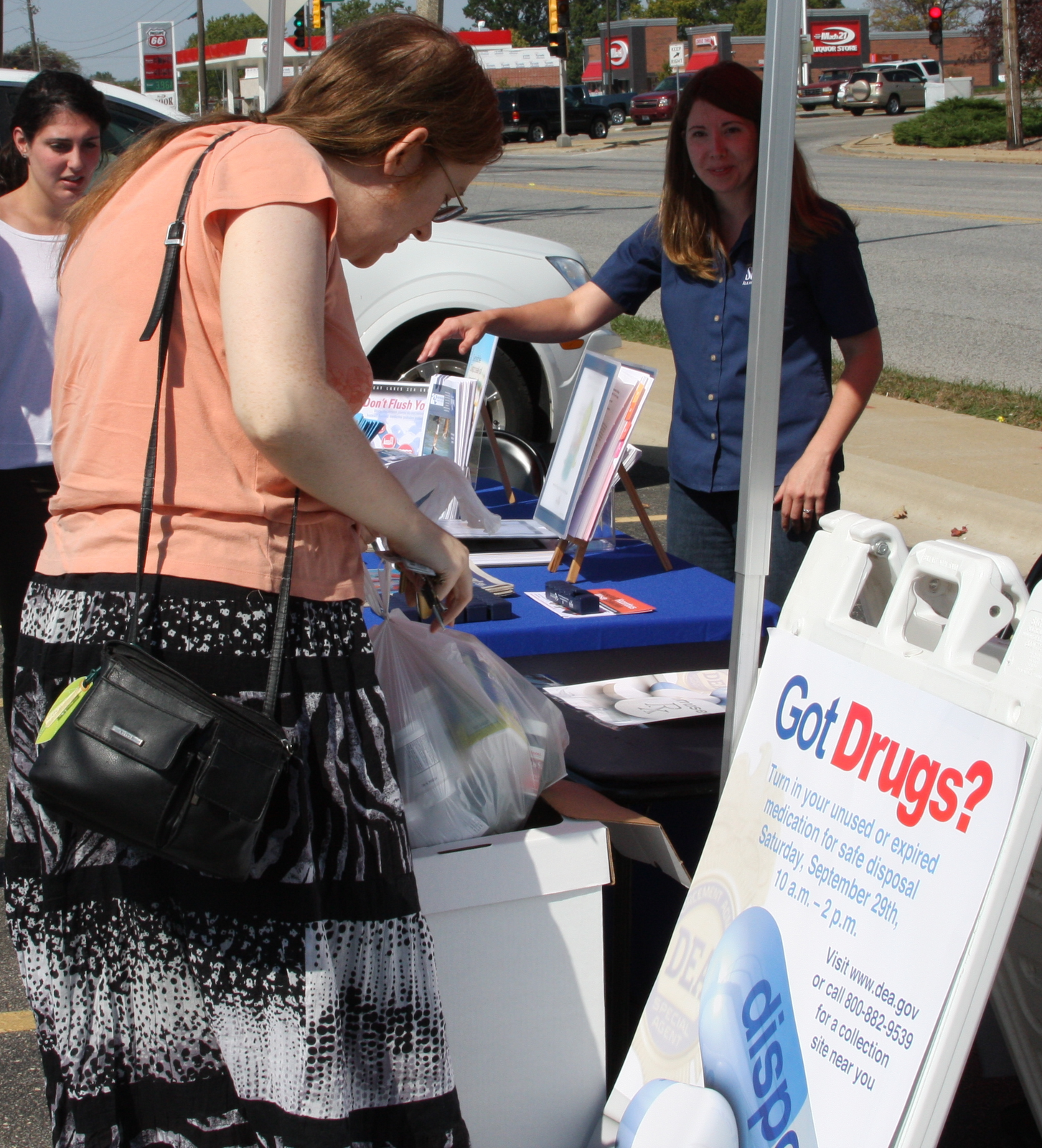
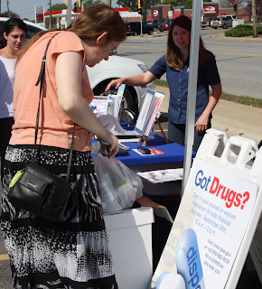 Thousands of residents in Illinois and Indiana came out last Saturday with the goal of ridding their homes of unwanted pharmaceuticals as part of the Drug Enforcement Administration’s (DEA) 5th annual National Prescription Drug Take-Back Day. From 10 a.m. to 2 p.m. police officers and volunteers in more than 200 locations in Illinois and 70 in Indiana collected bottles, boxes, and sometimes even garbage bags full of prescription and over-the-counter human and veterinary medications. Everything collected will be properly incinerated by the DEA.
IISG staffers were at two of these locations at Walgreens stores in Champaign and Urbana, joining local police officers and Walgreens representatives to collect medication, answer questions about the environmental effects of throwing away or flushing pharmaceuticals, and provide information on how to safely dispose of medications when collection events are not available.
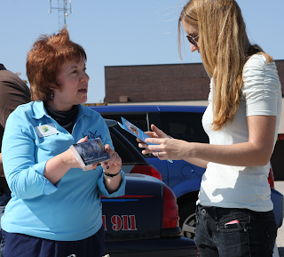
At both locations, people began lining up to hand over their medicine even before the event began. IISG volunteers heard from several people that they had been saving medications in anticipation of Saturday’s event. Take-back event regulars brought medications accumulated just since April’s DEA-sponsored event, but some brought pharmaceuticals with much older time stamps. One woman disposed of medicine she had been storing in her cabinet since 2005, and another brought in medication that was almost 20 years old. Exact figures on how many pounds of pharmaceuticals were collected during the 4-hour event won’t be announced by the DEA for several weeks, but police officers involved in the event described the day as on track to exceed previous take-back events.
Single-day collection events like this are an important way to limit negative impacts to wildlife and local waterways from prescriptions and medications that are improperly disposed of. A wide-range of pharmaceutical chemicals has been found in rivers, groundwater, and drinking water throughout the country due to medications being flushed down the toilet or thrown in the trash. The impact of these chemicals on long-term human health is still unknown, but a connection between pharmaceutical-contaminated waters and impaired development, behavior, and reproduction has been found in many species of fish and other aquatic wildlife.
Ridding homes of unused medication can also help protect the elderly, children, and pets from accidental poisonings and reduce instances of prescription or over-the-counter drug abuse.
IISG has been educating people on pharmaceutical stewardship issues and helping communities establish safe and legal permanent medicine collection programs for more than six years. For additional information on how to dispose of medicine between take-back events or in areas where collections are not available, visit www.unwantedmeds.org.
September 28th, 2012 by Irene Miles
A lot of people might know that Illinois-Indiana Sea Grant’s primary mission is to help protect and preserve the Southern Lake Michigan waters. But most people might not know about the many ways our program goes about doing just that.
With the help of staff members, researchers, educators, and more, we’ve produced a video that offers a glimpse at the program and the ways we work for and with the public to ensure safe waters and healthy ecosystems in both states.
Watch the video below to learn more about Illinois-Indiana Sea Grant, and share it with anyone who cares about keeping Lake Michigan healthy, beautiful, and safe.
September 25th, 2012 by Irene Miles
Runoff from a variety of land uses, including agriculture and industry, has been identified as one of the primary causes of harmful algal blooms (PDF) in the Great Lakes and surrounding waterways. The danger of these algal blooms comes in the form of botulism outbreaks, toxins, and harmful metabolites – all of which can have serious consequences for native plants, fish, and human health.
One potential solution that has been in use in Ohio is the planting of radishes, not only to help manage water and runoff, but also to improve soil quality for agricultural users.
“The radishes planted in northwest Ohio go in about this time of year and are left in the ground to die, explained our host, Allen Dean. Planting doomed radishes, it turns out, is an innovative technique he has used in recent years to improve soil nutrients and reduce runoff from his Williams County farm.
Here’s the basics on how it works: Farmers plant seeds for a plant called an oilseed radish. It doesn’t actually have to be that plant, but it needs to grow a foot or longer into the soil during the fall in a tubular shape, like a carrot or a parsnip. It also needs to grow a fair amount of foliage up on the ground. Radishes are usually more affordable.
It’s important that the plant drill down into the soil so that when it dies, usually during a mid-January freeze, it decays and leaves behind a v-shaped hole for snow and water to penetrate deeper. The decayed radishes Dean showed us looked like organic socks.
Oilseed radishes are particularly good at absorbing nutrients from the surface and sending them down into the soil as the tubular plant drills it way into the ground.”
Read the complete article above to find out more about how these plants are helping farmers and protecting the Great Lakes waters at the same time.
September 10th, 2012 by Irene Miles
A two-part article on WKSU’s website delves into recent research attempting to understand the causes of harmful and often very large algal blooms in Lake Erie. The potential negative impacts these blooms can have include depleting nutrients from the waterway, endangering fish and wildlife health, and causing economic concerns by prohibiting or discouraging recreation, tourism, and other industries.
Part one of the article delves into one major contributor identified by the research: agriculture.
“Financial viability is the bottom line for most farmers here along the Maumee River. The Maumee passes through 4.5-million acres of farmland before entering Lake Erie at Toledo. Along the way it picks up a lot of topsoil from farm fields. Attached to that soil are fine particles of phosphorus, one of the nutrients that helps crops grow, but also feeds algae blooms. No-till farming has reduced particulate phosphorus runoff by nearly 40-percent. But researchers from Heidelberg University say their thirty years of water quality data shows that another form of phosphorus – called dissolved phosphorus – has risen dramatically in recent years. And to reduce that nutrient enough to curb Lake Erie algae blooms will take a whole new set of techniques.”
The second article describes another common source of phosphorous and other problem substances – stormwater and sewage.
“The sport fishing industry, beach resorts, amusement parks – all took a hit from the 2011 algae outbreak. Connor says cities …not just farms…have to do more to stay on top of it.
Overflows from sewage systems that collect storm water and waste water are a fairly regular occurrence in Cleveland, Toledo, Detroit and other communities around the lake. And it’s a huge cost to fix it.”
There is a lot of interesting information in both articles, and the occurrence of and concern over these algal blooms isn’t limited to Lake Erie. All of the Great Lakes and other nearby waterways can be susceptible, so the results of studies such as these are important in helping communities prevent the same types of problems in their areas. Our friends at Michigan Sea Grant have produced a brochure for beach managers that outlines more information about algal blooms, and IISG has produced a card for homeowners that explains how to properly care for your lawn without contributing to the phosphorous problem.
September 6th, 2012 by Irene Miles
Much of the press and media attention on the growing Asian carp threat has been focused on the Chicago canal and Lake Michigan. But that is not the only potential entryway for the invasive fish to enter the Great Lakes.
“At the top of that list of secondary pathways is an area in northern Indiana called Eagle Marsh, which separates the Mississippi basin’s Wabash River from the Maumee River basin that feeds Lake Erie. The two watersheds have a history of merging in extreme rains, so to reduce the threat of carp making the jump into Lake Erie, the federal government has erected a fence between them.”
Read the complete article linked above for more information about other potential pathways that Asian carp might take.
September 4th, 2012 by Irene Miles

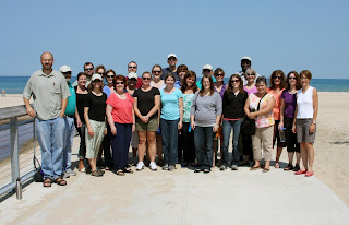
Last week, Illinois-Indiana Sea Grant had a two-day meeting and retreat at the
Indiana Dunes State Park in Chesterton, Indiana. In addition to devoting some time to planning and discussing current and future projects, we were treated to a couple of informative and scenic tours in the area, learning more about the extensive restoration work to protect the dunes, the state park and national lakeshore, and the water quality of Lake Michigan.

Staff members were able to join National Park Service workers on-site to learn about and get their hands dirty at the
Great Marsh Restoration Site not far from the dunes. Once very large, the remaining Great Marsh area is approximately 12 miles long and harbors a wide range of plants, animals, insects, and other beneficial organisms. Those native species are threatened by invasive species, however, and work is ongoing to plant and establish native species to bolster the wetlands’ resistance to invasive species and restore the natural balance of the area.
Informative, fun, and muddy, the chance to do on-the-ground work in restoring this watershed was a valuable experience for everyone involved, and offered a practical reminder of the importance of restoring and protecting these areas.
There are more terrific photographs of the restoration project and the lake shore on
Illinois-Indiana Sea Grant’s Facebook page. Head over and check them out, and be sure to plan a visit to the park for yourself.


