July 23rd, 2024 by Irene Miles
Illinois-Indiana Sea Grant (IISG) and University of Illinois Extension are seeking a visiting extension outreach associate to focus on IISG K-12 education by creating a new youth-centered digital learning product as well as developing, delivering, and evaluating other educational programming that increases Great Lakes literacy among Illinois and Indiana youth.
Responsibilities for this full-time, 12-month K-12 education position include:
- Develop a youth-centered aquatic invasive species (AIS) digital learning product
(e.g., website, online game) for middle-school-aged youth. This will include
evaluating or revising existing AIS curricula or supporting resources.
- Develop and deliver other educational programming such as teacher workshops,
curriculum development, and youth stewardship projects.
- Conduct evaluation research to determine the effectiveness of programming
and to use these findings to create innovative programs and improve existing offerings.
A bachelor’s degree in education, environmental education, natural sciences, or a related field is required, as is two years of experience developing and delivering digital educational content.
This position will be located in Chicago, Illinois. To view the complete job description and apply, visit the University of Illinois Job Board. The closing date is August 19, 2024.
July 18th, 2024 by Irene Miles
Illinois-Indiana Sea Grant (IISG) is announcing $890,000 of funding for five research projects in 2024−25. These projects will inform decision-making for some of the region’s pressing coastal issues, including the prevalence of contaminants, vulnerable shorelines, and water supply planning.
“We are enthused to support practical research projects of high import for the southern Lake Michigan region,” said Tomas Höök, IISG director.
For each of these two-year projects, the research team will share their data and results with broad audiences, whether through developing web tools, meeting with and informing key organizations or agencies, or engaging with the public.
Three projects are focused on assessing contaminant levels in Lake Michigan and its tributaries.
Jason Rohr, a biologist at the University of Notre Dame, will lead a project to use public datasets to better inform and estimate the environmental effects of contaminants in Lake Michigan tributaries. These water bodies are exposed to high levels of pollution from industry, agriculture, stormwater, and air pollution, which then flow into the lake. The researchers will integrate datasets into a web-based tool to assist decision-making associated with pollution-related hazards in the southern Lake Michigan region.
Several other projects will focus specifically on PFAS, or per-and polyfluoroalkyl substances, which are used in many products and industrial processes. PFAS are found in most waterways and they endure in the environment.
Also a Notre Dame biologist, Gary Lamberti and his team will quantify PFAS distribution in the lake’s tributaries in northwest Indiana, including in the environment and the food web, to assess the primary routes of PFAS exposure to sportfish and possible connections to local anglers. Daniele De Almeida Miranda, a research professor, will lead this work as the team documents the main routes by which PFAS is transported into streams connected to Lake Michigan.
Measuring PFAS from a different approach, David Lampert, an environmental engineer at the Illinois Institute of Technology, will lead a team that will test known contaminated waterways in the Chicago and northwest Indiana region to better understand the processes of bioaccumulation of PFAS from sediments and groundwater into benthic organisms. This project will develop an improved understanding of PFAS transport and the risks to these organisms and coastal communities.
Several scientists at the Prairie Research Institute will focus on coastal resiliency, specifically on the impacts of two different artificial reef complexes installed within the shallow nearshore of Lake Michigan to stabilize northern Illinois shorelines. Hillary Glandon, an aquatic ecologist at the Illinois Natural History Survey, and C. Robin Mattheus, a coastal geologist at the Illinois State Geological Survey, will measure species diversity and abundance and assess lake bottom and beach changes resulting from water-level variability and storms, which may be influenced by the presence of the reef structures.
Finally, researchers at the Illinois State Water Survey (ISWS) and the Chicago Metropolitan Agency for Planning will help address growing concerns about water sustainability in the Chicago region. Vlad Iordache, an ISWS hydrogeologist, will lead this effort to produce interactive groundwater models and decision support systems to help the south suburbs of Chicago understand water supply risks and plan for the future.
———————————————————————————————————–
Illinois-Indiana Sea Grant is one of 34 Sea Grant programs supported by the National Oceanic and Atmospheric Administration in coastal and Great Lakes states that encourage the wise stewardship of our marine resources through research, education, outreach and technology transfer. In partnership with the University of Illinois Extension, and Purdue University Forestry and Natural Resources, Illinois-Indiana Sea Grant brings science together with communities for solutions that work.
July 11th, 2024 by Irene Miles
Illinois-Indiana Sea Grant (IISG) is hiring a communication coordinator to oversee communication for the program. The communication coordinator will be situated in Purdue University but will work across both states to lead efforts to develop and maintain programs and products that promote science-based knowledge and highlight IISG’s research, outreach and education efforts.
Responsibilities for this full-time position will include:
- Managing the IISG communication program and providing relevant support to IISG specialists.
- Overseeing the intake of new work and managing the delivery of communications products in a timely manner.
- Working with researchers, educators, and outreach professionals in Indiana and Illinois to develop and disseminate unbiased, science-based communication products and programs.
- Researching and incorporating emerging technologies for communicating with key audiences.
A bachelor’s degree is required in communication, marketing, journalism, English, graphic design, communication planning, natural resources or a related field. Also, four years of experience, including two or more years’ managing a team of communicators and two or more years’ experience with science communication, writing, proofreading, and editing.
To learn more about the communication coordinator’s responsibilities and qualifications, visit the announcement on the Purdue University Job Board. This opportunity is open until the position is filled. An initial review of applications will take place on August 8, 2024. For questions about the position, contact IISG Assistant Director Stuart Carlton.
Purdue University is an equal access/equal opportunity university. We strongly encourage women, minorities, and people from traditionally underrepresented groups to apply. For more on Illinois-Indiana Sea Grant’s commitment to inclusion, see our values statement.
July 10th, 2024 by Irene Miles
As part of an Illinois-Indiana Sea Grant (IISG) funded research project, a Chicago middle school girl has discovered a new compound in goose droppings that has shown activity against cancer. As a result, she will soon be an author on an article submitted for publication in a biomedical research journal.
Camarria Williams was recruited through the Boys & Girls Club of Chicago along with other middle schoolers to take part in an opportunity in a University of Illinois Chicago laboratory to do real science.
“Chicago has a long history of disparities, whether they’re rooted in socioeconomics or race-based policies—this is an opportunity to use high end biomedical science to help bridge some of the documented gaps in STEM participation,” said Brian Murphy, a medicinal chemist in the UIC College of Pharmacy, who leads this program. “By working with local organizations or community centers we can bring citizens into the process of discovering antibiotics.”
Murphy, along with Jin Yi Tan, a UIC graduate student who leads a team of volunteer graduate students and postdoc mentors in the Chicago Antibiotic Discovery Lab, developed this program to engage youth from marginalized neighborhoods in STEM education using a novel approach. The kids are introduced to scientific experiments and participate in a variety of learning opportunities.
At the center of these activities is the assignment for these young scientists to collect samples from their environments to test in the laboratory for possible antibiotic properties, and they are very much involved in making decisions throughout the screening process.
Creating the conditions that made it possible to bring youth into the lab to do this work began a few or more years ago when Murphy set out to make the search for antibiotics in the environment cheaper, better, and more efficient.
With some disease-causing microbes developing resistance to our medicine chest of antibiotics, this work has become especially important.
Murphy and his team adopted technology that would help them develop a leaner, more efficient microbial library that would have fewer redundancies. And they repurposed older technology to allow them to very rapidly screen for antibiotic activity.
“When I joined the lab,” said Tan, “I worked to integrate these different innovative methods into one pipeline to make the process much more efficient, as well as add high throughput robotics to automate many of the steps.”

UIC graduate student Jin Yi Tan leads a team of volunteer graduate students and postdoc mentors in the Chicago Antibiotic Discovery Lab. She developed this Sea Grant project to engage youth from marginalized neighborhoods in STEM education.
Automating the process has also made the process simple enough that Tan, who was funded as an IISG Grad Student Scholar to build on Murphy’s project, could teach middle school students how to do it.
The team has worked closely with the James R. Jordan Boys & Girls Club in the near west side of Chicago as well as the Bartlett J. McCartin Boys & Girls Club in the Bridgeport neighborhood to recruit youth to take part in the program.
Over the span of several years, 22 have volunteered for this opportunity—three groups of 5−7 middle school-aged Boys & Girls Club members and a small group of high school students.
The youth who joined the Chicago Antibiotic Discovery Lab chose places and objects to sample for bacteria in their environment—they sampled lake water, insects, and flowers, but also swabbed different kinds of surfaces such as a playground slide and an air conditioning filter.
Altogether, they collected 40 samples and processed over 5,500 antibiotic bioassays. Of these, some were chosen for further analysis and the most promising ones were eventually screened by Tan.
“You can expect that only about 1 to 5% of any isolates would really be a hit,” said Tan. “Some of the samples did have antibiotic properties that were already known—they had been previously discovered. It’s still really exciting for the kids when we tell them that we found an active antibiotic molecule in their sample.”
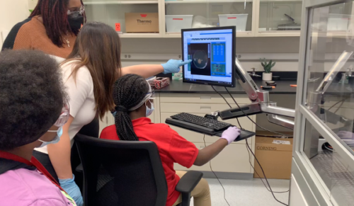
Several middle-school-aged youth (seated and in pink) are learning how to operate the robot to pick bacterial colonies. (Photo courtesy of Chicago Antibiotic Discovery Lab.)
Camarria Williams’s successful sample was of goose droppings near a pond in Chicago’s Garfield Park. Further testing revealed it to be a new compound of a known family of compounds that have shown disease-fighting properties in the past. The small differences in this molecule may indicate that its disease-fighting properties are different too. Much to everyone’s surprise, the sample also showed activity against several different cancer cell lines.
“We identified some compounds to be cyclic peptides, which are famous for having biologic activity,” said Murphy. “Amazingly, it turns out these particular compounds don’t have antibiotic activity, but they do have cytotoxic activity—activity against some cancer cell lines.”
Other compounds in the goose droppings are being tested for their antibiotic activities.
While the destination, in terms of discovering a new medicinal tool is potentially groundbreaking for the students that go through this program, the journey—the learning process—is the real reward.
Over 13 weeks, as the youth screened their samples, they engaged in STEM education sessions focused on Great Lakes environmental issues, biology, engineering, and robotics. Throughout, they were introduced to careers related to the subject at hand, including engineering and other sciences. For example, IISG’s Aquatic Education Associate Megan Gunn was interviewed by the kids about her experience doing Great Lakes science.
“We work with really small groups, so a lot of the mentoring is one to one,” said Tan. “We really notice kids and their interests. One cohort was really interested in the engineering component. And then our most recent cohort was more interested in biology. Since it’s such a small group, we can tailor to their interests.”
Tan shared her experience of watching some students become more confident over the course of the program. “I think the most rewarding part for me is seeing the progress as kids became more confident in themselves over time,” she said. “Like, yeah, I can program stuff. I can do this. I chose these samples.”
Murphy is hoping to continue bringing youth into the antibiotic discovery process, but perhaps with more of an emphasis on high school students.
“The idea would be to pair high school students with near-peer mentoring from graduate students and postdocs,” said Murphy. “All at a time when they’re starting to think about being adults themselves and are asking, is it possible for me to have a career in science?”

Jin Yi Tan (left) is teaching a high school student how to use the high-throughput robotic colony picker in the room to the right.
Illinois-Indiana Sea Grant is one of 34 Sea Grant programs supported by the National Oceanic and Atmospheric Administration in coastal and Great Lakes states that encourage the wise stewardship of our marine resources through research, education, outreach and technology transfer. In partnership with the University of Illinois Extension, and Purdue University Forestry and Natural Resources, Illinois-Indiana Sea Grant brings science together with communities for solutions that work.
July 8th, 2024 by Irene Miles
PFAS are chemicals commonly found in consumer goods that are making their way into drinking water supplies where they are a risk to human health, but there are steps people can take to protect themselves.
PFAS, per- and polyfluoroalkyl substances, are a group of more than 15,000 man-made chemicals that are sometimes added to products to help them resist grease, oil, water, and heat. These “forever chemicals” are found in a wide array of consumer goods, including clothing, cosmetics, food packaging, carpets, cookware, and cleaning products. As a result of their widespread use, PFAS have migrated into soils, lakes, rivers, and streams across the U.S.
No level of PFAS exposure comes without risk to human health, according to a recent press release from the U.S. Environmental Protection Agency (EPA). PFAS break down slowly and can accumulate in aquatic plants and animals as well as people. Exposure to PFAS through the skin or digestive system has been linked to increased risk of certain cancers, kidney and heart disease, and reproductive issues like low birth weight and birth defects. This spring, EPA announced the first federal legal protections to protect public drinking water from PFAS.
Sarah Zack, pollution prevention specialist with Illinois-Indiana Sea Grant, works with the public to raise awareness about water contaminants, including PFAS.
“It’s not easy to reduce our risk from PFAS chemicals because they are ubiquitous in the environment,” Zack said. “But there are some simple ways to reduce your exposure and protect your health.”
- Replace nonstick pans at the first sign of scratches, and do not heat beyond the recommended temperature, which is typically 400 degrees Fahrenheit. Avoid using nonstick cookware altogether, if possible, and opt for stainless steel, cast iron, or ceramic.
- Microwave popcorn bags, takeout containers, and fast-food packaging can be coated with PFAS to prevent sticking. Be a cautious consumer and do research before eating food from this packaging.
- Avoid stain-resistant carpets, upholstery, and other fabrics. Vacuum regularly to remove PFAS that can accumulate in dusty fabrics.
- Leave shoes at the door to avoid tracking chemicals into your home.
- Check advisories before eating locally caught seafood.
- Contact your public water utility about whether your drinking water has been tested for PFAS. If you are on a private well, conduct regular testing. Consider an at-home water filtration system if you are concerned about the FAS level in your water.
You can learn more by listening to a University of Illinois Extension Spotlight on Natural Resources podcast, in which Zack discusses the problem of PFAS.
June 27th, 2024 by Irene Miles
Summer 2024 is officially underway and if it’s summer, it’s intern season at Illinois-Indiana Sea Grant (IISG). Every year since 2011, we have hired college undergrads to spend the summer working closely with our specialists and taking part in other learning opportunities.
This year five interns have joined us and they will work in a variety of areas including sustainable land use planning, water resources and economics, green infrastructure, and environmental education.
Two additional interns were hired through Sea Grant’s national Community Engaged Internship program that aims to broaden participation in water resources by offering paid internships to undergrads from under-resourced, underrepresented and/or indigenous and tribal populations. We are collaborating with the National Park Service and Chicago Wilderness to co-host these two interns.
Summer is also prime time to think about water safety as the hot weather kicks in and many of us head to the beach. IISG has developed a four-part video series in partnership with the Indiana Dunes National Park to encourage safe recreation in Lake Michigan. The videos explain dangerous waves and currents and even cold-weather concerns and provide sensible safety tips. And don’t forget to check with our buoys for up-to-the minute lake conditions before you head out.
In Illinois state parks and other natural areas, conservation police officers are up to speed this summer on aquatic invasive species (AIS)—they have new knowledge and tools to combat the spread of these species and protect the state’s natural resources. Recently, 150 officers attended a hands-on workshop that was developed by our AIS team in collaboration with Carena van Riper’s lab—she’s a conservation psychologist at the University of Illinois. Through this training, the officers were able to directly engage with various AIS specimens and they learned how to distinguish between native and invasive species.
In the latest issue of Outdoor Illinois, an Illinois Department of Natural Resources online journal, you can read an update to an ongoing study to track fish in the busy downtown waters of the Chicago River and connected waterways. The team from IISG, Shedd Aquarium, and Purdue University Department of Forestry and Natural Resources is seeing some impacts on fish movement from the river’s combined sewer overflows. For example, last summer when, in response to a large rainstorm, raw sewage was pumped into Bubbly Creek, acoustically-tracked fish rapidly left this area and did not return throughout the summer.
In IISG staff news, we welcome Julie Fiorito, our new K-12 education specialist. The focus of Julie’s work is to increase Great Lakes literacy among Illinois and Indiana youth through development, delivery, and evaluation of science-based educational programming. Fiorito has extensive experience as a high school teacher planning, directing, and coordinating various educational programs. She earned a Bachelor of Science in biology education from Illinois State University and a Master’s from the University of Illinois.
Kayla Wright is our new community resilience extension specialist. A new member of Kara Salazar’s Sustainable Community Planning Team, Kayla will use her local government and community engagement expertise to provide leadership and support to further efforts with the Great Lakes Environmental Justice Thriving Communities Technical Assistance Center and the Indiana Renewable Energy Planning and Technical Engagement Collaborative. She has a bachelor’s degree from Indiana University.
Summer brings a round of educational opportunities for us to share with residents, decision-makers, educators, and partners too. Some examples:
- Registration opens on July 1 for the American Citizen Planner Indiana fall session. This 16-week course develops knowledge and skills for residents, including advisory plan commissioners or citizen advocates, who are unfamiliar with the concepts and regulations of local government planning.
- The IISG education team will engage 5−12 grade educators in a workshop on July 24−25 at the Wild Mile along the Chicago River. Participants will hear about the history and ecology of the site, as well as learn water quality testing skills to bring back to their students.
- Do you want to know more about local watershed concerns and volunteer to help keep them healthy? You can register until August 14 to join the Illinois-Indiana Master Watershed Stewardship Program class, which will take place at Purdue University Northwest from August 20 to October 8.
- On August 10, come ready to help remove rusty crayfish from the Fox River in Illinois’ Kane County at the annual Rusty Rodeo. Our AIS team will be joining in the festivities to share information about invasive crayfish.
May 28th, 2024 by Irene Miles
Microplastics have been found in the water just about everywhere, as well as in fish and other organisms. At this point, the effects these microplastics are having on fish larvae growth and development, as well as their behavior, isn’t well understood. Nor is any combined impact with other known contaminants.
An Illinois-Indiana Sea Grant faculty scholar set out to gain some insights on these issues and found that fathead minnow larvae are more impacted when their parents have been exposed to microplastics rather than when they ingest it themselves.
Jessica Ward, an animal behavior scientist at Ball State University and graduate student Kenzie Persinger evaluated the impacts of microplastics and a common environmental estrogen on early life stages of the fathead minnow. (Fathead minnows are one of EPA’s model species for toxicology research and are widely used in lab work.)
“One of the main questions we hoped to answer was whether exposing parental fish to microplastics, as well as microplastics associated with endocrine disrupting chemicals, showed downstream behavioral effects in offspring,” said Ward.
The contaminants were introduced through the fish’s diet in amounts that reflect what they would likely experience in the real world. Adult minnows were exposed to microplastics alone or along with estrogen and then allowed to spawn.
After hatching, half of these larvae received continued exposure for 21 days and both this group and the unexposed control group were tested in how they performed in swimming trials.
The researchers measured a significant overall effect on fathead minnow offsprings’ swimming performance when their parents were exposed to microplastics, with or without estrogen. These larvae showed more hyperactive behavior.
“Compared to the control group, the larvae swam farther and faster, which is an indicator of hyperactive behavior,” said Ward. “Hyperactivity is thought to increase the probability of predation.”
The researchers observed no further changes in larvae that received more exposure after hatching, and no significant effects were observed from larvae only exposed after hatching.
“This suggests that parental exposure has a stronger effect on offspring behavior than direct exposure of the offspring themselves,” said Ward.
April 9th, 2024 by Irene Miles
Every five years, Lake Michigan is the focus of intense research and monitoring when scientists come together to answer critical questions and fill information gaps. A report summarizing the results of the most recent data collection on the lake is now available.
Each year since 2002, through the Cooperative Science Monitoring Initiative (CSMI), multiple federal, state, and university scientists gather on one of the Great Lakes to take part in coordinated research. CSMI is a binational program organized through the U.S. Environmental Protection Agency Great Lakes National Program Office and Environment and Climate Change Canada.
Lake Michigan was slated for 2020 to be its CSMI field year, but due to the pandemic, the sampling actually took place in both 2020 and 2021. Research priorities included learning more about the lake’s changing food web dynamics, the impacts of contaminants and bacteria, and the connections between watersheds and tributaries to the lake’s water quality.
Quagga mussels featured prominently in the key findings of the compiled 2020 research results—they are the dominant invertebrate species in the lake. The good news is that the quagga mussels’ population density has somewhat stabilized, on the other hand, their numbers in deeper areas of the lake continue to slowly expand.
“Quagga mussels continue to play a key role in nutrient and primary production dynamics in Lake Michigan,” said Paris Collingsworth, Illinois-Indiana Sea Grant (IISG) Great Lakes ecosystem specialist and Purdue University researcher. “Quantifying the effects of these mussels on the energy flow throughout the lake is an important concern for the management community of Lake Michigan.”
Collingsworth provides leadership in collaboration with EPA scientists, defining critical questions and coordinating research efforts of various agencies for large-scale studies. He works with the lake partnerships for each lake as they define CSMI research priorities, and with scientists as they set up studies and analyze data.
The significant presence of quagga and zebra mussels, or dreissinids, in Lake Michigan and their consumption of so much of the energy of the lower food web have left lake waters clear. CSMI research showed that this extreme clarity has shifted the vertical distribution of planktonic organisms lower in the water column to avoid high ultraviolet radiation in surface waters.
Mortality from ultraviolet exposure may also be a bottleneck for fish larvae survival and potential recruitment in Lake Michigan, but some species may fare better than others.
For example, higher pigmentation on bloater larvae compared to those of alewife suggests that bloater can endure ultraviolet exposure. In fact, findings reveal that while alewife larvae catches in 2021 were 3.7 lower than in 2015, bloater densities were 2.2 times higher in 2021.
Researchers found that quagga mussels are having an impact on fish populations in other ways. When the quagga mussel veliger, a larval stage, is part of the larval fish diet, this reduces fish growth and survival rates.
“The long-term tracking of invasive mussels and other lower food web organisms by CSMI partners has been extremely helpful to all lake managers because it improves our understanding of lake ecosystem processes, informs management decisions and provides sound scientific information on a changing ecosystem that can be shared with Great Lakes anglers and stakeholders,” said Vic Santucci, Lake Michigan fisheries program manager with the Illinois Department of Natural Resources.
The scientists also studied contaminants in Lake Michigan and found evidence that spottail shiner may be exposed to a sediment source of PFAS (or per- and polyfluoroalkyl substances). These compounds are called “forever chemicals” because they don’t break down in the environment.
To learn more about these results and many others, the Cooperative Science and Monitoring Initiative Lake Michigan 2020 Report with key findings and an executive summary is on the IISG website.
March 27th, 2024 by Irene Miles
This spring, Illinois-Indiana Sea Grant (IISG) is sharing opportunities to further research, engage audiences with new information, and bring experts together to share knowledge and set new goals.
The 2024 Graduate Student Scholars program is ramping up, with the program open to graduate students from institutes of higher learning in Illinois and Indiana. Applicants can request up to $10,000 to support research expenses, stipends, travel, or other activities that help expand the scholarly or societal impact of their research. To see how this program is going, you can read blog posts describing past and current scholars’ projects in our newsroom.
We have developed two new IISG education products that offer exciting approaches to facilitate learning. Both products are currently being pilot-tested and will be available later in the year.
First, years of support for high schools that incorporate aquaponics into their STEM classwork has led to the development of a new curriculum. Aquaponics is a form of sustainable agriculture that connects raising fish and growing plants through an interdependent relationship. The IISG High School Aquaponics Curriculum is nine lessons that comprehensively cover aquaponics but is also designed so that an educator can pull out a single component to reinforce classwork.
The second educational tool brings Great Lakes Areas of Concern (AOC) to the classroom using 360-degree virtual reality technology. IISG’s Ashley Belle, Megan Gunn and their invaluable intern Xuanshu Lin developed an immersive experience along the Grand Calumet River in northwest Indiana. Creating a novel way to introduce students to environmental science in the real world, the virtual reality images feature degraded areas of this AOC as well as sites that have been remediated and restored. The specialists also developed a complementary curriculum for use with middle and high school students.
In other news, I’d like to congratulate several well-deserved recent IISG award winners. Research Coordinator Carolyn Foley received the Purdue University Forestry and Natural Resources 2023 Outstanding Administrative/Professional Staff Member Award. Carolyn was recognized for her leadership, resourcefulness, and selfless contributions to the department and IISG. Carolyn has served IISG’s research program since 2010 and is the primary contact for questions related to requests for proposals and IISG-funded research projects. She also developed and initiated the IISG Scholars Program in 2021.
Greg Hitzroth, our aquatic invasive species (AIS) outreach specialist, was chosen for the 2023 Illinois Lake Management Association Lake Guardian Award. Since 2012, Greg has worked to inform key audiences to help prevent the spread of AIS in Illinois waters and in the Great Lakes. As IISG has become the primary source of AIS outreach and education in Illinois, Greg has come to be seen as a regional expert regarding the “organisms in trade” pathway. This characterization came about through his efforts to develop well-informed outreach tools as well as his willingness to open new doors and try new approaches to this work.
Spring brings a round of educational opportunities for us to share with residents, decision-makers, researchers, and partners too.
- To mark the fifth year of our native plant tournament, formerly known as “Mulch Madness,” we invite you to get ready for Rain Garden Rumble! The competition is in progress, but you can still get in on the fun. Visit the Red Oak Rain Garden’s social media pages, where you can vote for your favorite plants. Vote totals will determine which of the 28 plant species will move on to the next round and ultimately be crowned the 2024 champion.
- If you want more hands-on gardening knowledge, the Rainscaping Education program will hold a two-day training in Illinois’ Kane County; a how-to on installing rain gardens, a type of green infrastructure. Rain gardens can capture stormwater, helping to prevent floods and protect local water quality. The sessions on May 2 and 3 may include experiential training activities, field techniques, and field trips to view rainscaping projects.
- The 2024 Spring Fisheries Meeting will take place in the evening of March 28 at the Wilmette Harbor Club. Topics will include the offshore food web, largemouth bass in the Chicago River, and harvest patterns in nearshore Lake Michigan. If you can’t attend this in-person event, a virtual meeting and Q&A session with the speakers will take place on April 3.
- Registration is open for the Emerging Contaminants in the Environment Conference on April 24–25. This virtual conference will feature 15-minute presentations and lightning talk sessions on the latest in emerging contaminant research, policies, and outreach in the soil, water, and air. Registration closes April 10.
Tomas Höök
Director, Illinois-Indiana Sea Grant
Illinois-Indiana Sea Grant is a partnership between NOAA, University of Illinois Extension, and Purdue University Forestry and Natural Resources, bringing science together with communities for solutions that work. Sea Grant is a network of 34 science, education and outreach programs located in every coastal and Great Lakes state, Lake Champlain, Puerto Rico and Guam.

