The 2023 issue of Illinois-Indiana Sea Grant’s magazine, The Helm, is now available. This annual publication is a collection of program research, outreach and education success stories as well as ongoing activities to address coastal concerns. This issue is focused on stormwater management with green infrastructure, PFAS, and more, including how students are learning about water quality through hands-on opportunities.
Green infrastructure helps communities—large and small—be ready for the future
With a Hydrolab, Students study their own environment
Study finds PFAS in all tested Lake Michigan sportfish and their prey
Aquaponics offers high schoolers a hands-on way to learn science, math, and more
Illinois-Indiana Sea Grant is a partnership between NOAA, University of Illinois Extension, and Purdue University Forestry and Natural Resources, bringing science together with communities for solutions that work. Sea Grant is a network of 34 science, education and outreach programs located in every coastal and Great Lakes state, Lake Champlain, Puerto Rico and Guam.
Illinois-Indiana Sea Grant (IISG) and Purdue’s Department of Forestry and Natural Resources are seeking a coastal resilience specialist. In this role, you will develop a program that includes technical guidance, extension and applied research related to physical coastal resilience along the southern Lake Michigan shoreline.
Responsibilities will include:
Providing technical assistance and consultation for coastal communities related to coastal resilience and engineering projects, with a focus on human safety, infrastructure protection, erosion prevention and ecological benefits.
Conducting applied research to inform extension work, focused on coastal resilience and engineering projects.
Sharing outreach and research information through appropriate media and through presentations, reports and peer-reviewed publications.
Collaborating with state and federal agencies, non-government organizations, university researchers and Sea Grant/Extension professionals.
Seeking external funding to grow and support the work.
A Master’s degree is required in coastal processes, earth sciences, environmental sciences, engineering (coastal, civil, environmental), or a related field. Plus, four years of experience with coastal resilience extension, engineering, research and/or technical support is required.
To learn more about the position’s responsibilities and qualifications, visit the job posting on the Purdue University Job Board. Applications are due by November 30, 2023 or until the position is filled. For questions about the position, contact Tomas Höök, IISG director at thook@purdue.edu.
Purdue University is an equal access/equal opportunity university. We strongly encourage women, minorities, and people from traditionally underrepresented groups to apply. For more on Illinois-Indiana Sea Grant’s commitment to inclusion, please see our values statement on our website.
The Great Lakes Sea Grant Network (GLSGN) met in September for the first time in four years. Hosted by Illinois-Indiana Sea Grant (IISG) in Evanston, Illinois, the gathering offered opportunities for Sea Grant staff from throughout the Great Lakes region and the national office to plan, share resources and knowledge, and celebrate people and projects. It was good to see familiar faces and meet new ones.
At the meeting’s Awards Banquet, Amy Shambach, our aquaculture marketing outreach associate, was honored with the 2023 GLSGN Early Career Award. Amy has been with IISG since 2019 and has developed numerous outreach products, including videos, factsheets, and websites. She has organized and led webinars and workshops in the two states and helped lead Great Lakes-wide projects.
Throughout her four years with IISG, Amy has worked closely with fish farmers and has been someone they can turn to for guidance and information. As a result, she was able to help some farmers successfully secure federal support during COVID.
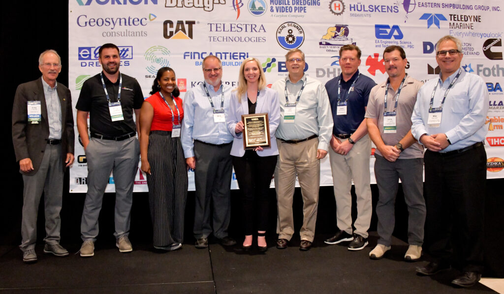
In other honors, earlier in the summer, IISG’s Ashley Belle, as part of the Spirit Lake Project team, shared the 2023 Western Dredging Association Environmental Excellence Award for Partnerships and Outreach/Education. Spirit Lake, located in the St. Louis River Great Lakes Area of Concern, is undergoing an environmental cleanup. Throughout that process, Ashley and the team have provided public meetings, regular updates delivered to residents, online photo galleries, and an onsite kiosk.
In other good news, we have announced our 2024 Knauss Fellowship finalist. Samantha Garcia, a master’s candidate in natural resources at the University of Illinois, will bring her background in researching invasive species, her previous fellowship experience in applied statistics, and her work bringing science and communication to marginalized communities to this fellowship.
The Knauss fellowship is a one-year paid opportunity in Washington D.C. for current and recent graduates from advanced degree programs (MS, PhD, JD) to apply their scientific knowledge and experiences to policy and public administration. Visit our fellowship page to learn more about applying for the 2025 cohort.
We are happy to welcome two new members to our aquatic invasive species (AIS) team. Natalia Szklaruk is our new AIS educator who will equip the public with essential tools, knowledge, and resources to prevent the introduction and spread of these species. Karter Burgdorf, the new AIS outreach associate, will research human knowledge and behaviors driving non-native aquatic species introductions in southern Lake Michigan.
The fall season brings a round of workshops to share new knowledge to extension educators, teachers, and fishers.
Purdue and Illinois Extension educators have the opportunity to take part in Purdue Rainscaping Education Program training. This effort will expand the expertise and reach of this bi-state program that helps communities install rain gardens and other green infrastructure to manage stormwater. These newly trained educators will bring this knowledge to master gardeners, local decision makers, and others in their region.
We have a learning opportunity for teachers and other educators. The Aquaponics Teacher Training Workshop will take place on Saturday, November 4, at the Chicago High School for Agricultural Sciences. In addition to information about aquaponics, this free, all-day workshop will include a tour of the high school’s aquaponics space, information about mini-grants, and a free water quality test kit.
The fall 2023 Lake Michigan Fisheries Workshop will take place in person on the evening of Wednesday, November 1 at the Portage Lakefront Riverwalk Pavilion. A virtual workshop and Q&A session with the speakers is scheduled for the evening of November 9 via Zoom. Topics will include a discussion of tracking fish with acoustic telemetry and emerging research on PFAS in Lake Michigan fishes.
Finally, speaking of tracking fish with telemetry, the Chicago Tribune reported on an IISG collaboration with Shedd Aquarium and Purdue University’s Department of Forestry and Natural Resources to track fish movement in the Chicago River. Researchers placed a total of 28 acoustic receiver devices in downtown waters and implanted acoustic tags in many largemouth bass, bluegill, and common carp.
Collectively, these tags and receivers will help us understand and visualize how fish in this system move in response to factors such as habitat enhancements, sewage overflow events, and seasonally changing conditions.
Illinois-Indiana Sea Grant is a partnership between NOAA, University of Illinois Extension, and Purdue University Forestry and Natural Resources, bringing science together with communities for solutions that work. Sea Grant is a network of 34 science, education and outreach programs located in every coastal and Great Lakes state, Lake Champlain, Puerto Rico and Guam.
At the recent Great Lakes Sea Grant Network meeting in Evanston, Illinois, Amy Shambach, Illinois-Indiana Sea Grant aquaculture marketing outreach associate, was presented with the 2023 Great Lakes Sea Grant Network Early Career Award.
Shambach has been in her role with IISG since 2019. Since then, she has developed numerous outreach products, including videos, factsheets, and websites. She has organized and led webinars and workshops in the two states and helped lead Great Lakes-wide projects.
Throughout her four years with the program, Shambach has worked closely with fish farmers—she has been someone they can turn to for guidance and information. As a result, she was able to help some farmers successfully secure federal support during COVID and then when an ice storm hit southern Illinois.
“It is unusual for someone to launch so many high-output, high-impact programs so early in their Sea Grant career, especially when they begin the job with little outreach experience,” said Stuart Carlton, IISG assistant director. “However, Amy is not usual, she is special, and is well deserving of recognition for her work.”
Ashley Belle, third from left, and the Spirit Lake Project Team, were presented with a 2023 Western Dredging Association Environmental Excellence Award for Partnerships and Outreach/Education.
Also honored at a recent event, IISG’s Ashley Belle is part of an award-winning team working to inform residents and other stakeholders in a Great Lakes Area of Concern that is undergoing an environmental cleanup. Belle leads outreach efforts for the Spirit Lake Project Team that was recently presented a 2023 Western Dredging Association Environmental Excellence Award for Partnerships and Outreach/Education.
Spirit Lake is located in the St. Louis River between Minnesota and Wisconsin and is part of one of the largest Great Lakes Legacy Act sediment remediation projects. This work takes place near the Duluth, Minnesota neighborhood of Morgan Park and a culturally significant tribal site—Spirit Island.
As the cleanup progresses, Belle and the team have provided public meetings, regular updates delivered to residents, online photo galleries, an onsite kiosk, and more.
When it comes to PFAS, scientists have found these “forever chemicals” in soil, water and air in sites around the country and the world. Now, researchers have found PFAS in every Lake Michigan fish they sampled and a particularly toxic form of PFAS in most of the lake’s sportfish.
PFAS is short for per- and polyfluoroalkyl substances, which encompass thousands of compounds that don’t break down in the environment. They are used in many everyday items like nonstick cookware, water- or stain-resistant clothing or carpeting, cosmetics, and even toilet paper.
Along with their persistence and growing presence in the environment, these chemicals may have human health impacts, such as impairing one’s immune system, increasing the risk of some cancers, and delaying development in children.
With funding from Illinois-Indiana Sea Grant (IISG), scientists from the University of Notre Dame—led by biologist Gary Lamberti and nuclear physicist Graham Peaslee—set out to assess the presence of PFAS in Lake Michigan fish and how these chemicals move through the lake’s food web, which had not been previously studied.
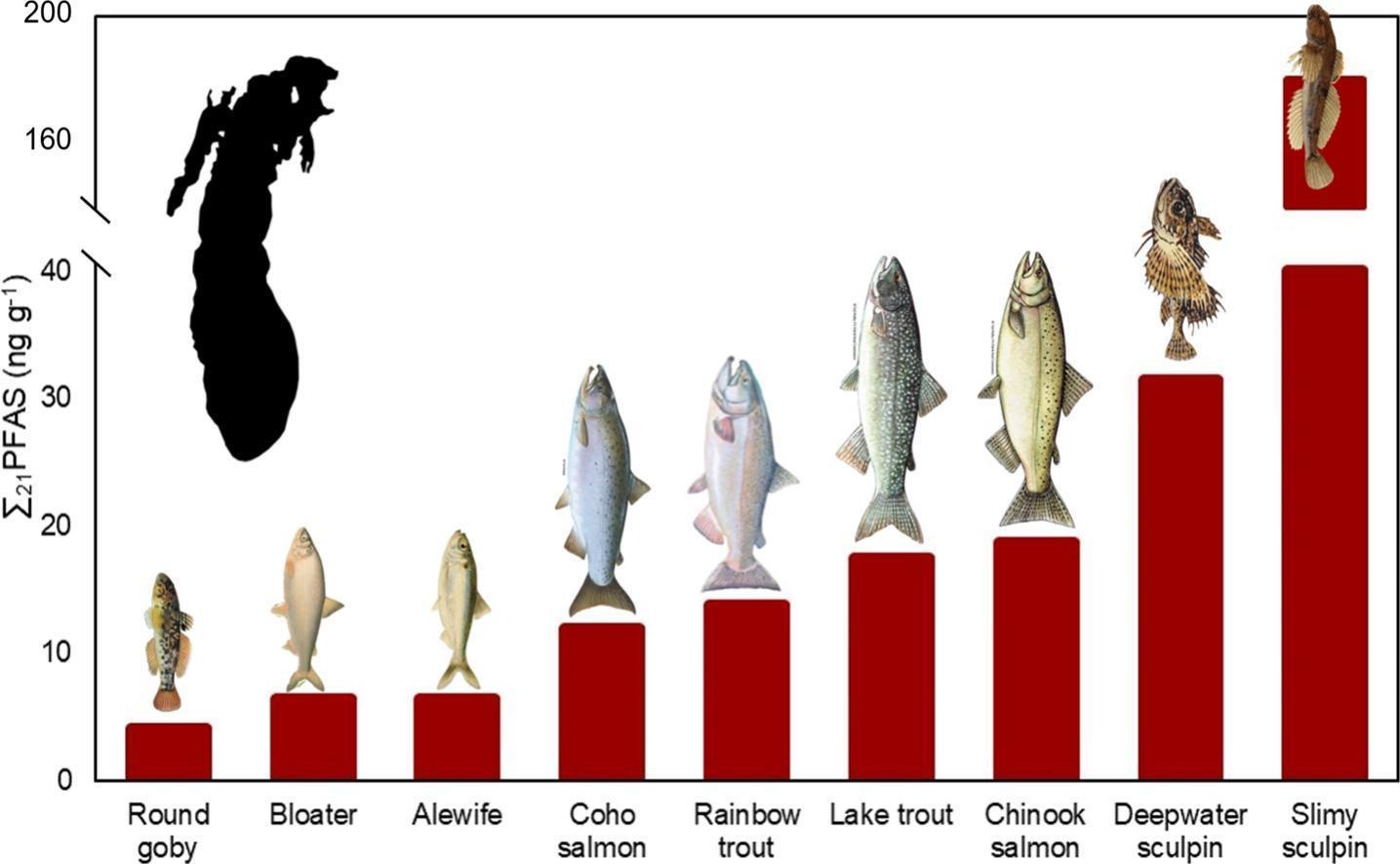
“We tested over 100 sportfish—chinook salmon, coho salmon, rainbow trout and native lake trout—and another 100 or so prey fish from all four quadrants of Lake Michigan,” said Daniele De Almeida Miranda, a postdoctoral associate working on the project.
They found PFAS in all sampled fish, both predator and prey, and in similar amounts and composition throughout the lake. The good news in terms of Lake Michigan—the study showed PFAS levels were lower there than in most Great Lakes.
Of notable concern though, was the widespread presence and level of PFOS (or perfluorooctane sulfonic acid) in the lake’s fish. These compounds were identified in more than 95% of sampled fish, especially salmon and trout.
“PFOS are a type of PFAS that are very toxic, even in low concentrations,” said Miranda. “For that reason, these compounds were phased out of production in 2002. Over 20 years later, PFOS are still the main PFAS compounds that we are seeing in Lake Michigan fish.”
These dangerous substances were also more likely than other tested PFAS compounds to bioaccumulate, meaning to move up the food chain from smaller to larger fish, potentially resulting in higher concentrations in popular sportfish.
“While bioaccumulation is straightforward with some contaminants, such as PCBs or heavy metals, it’s not with PFAS,” said Miranda. “For some PFAS compounds we found higher levels in predator fish such as chinook and lake trout, than in prey fish, but sometimes it was more variable.”
Lamberti noted that PFAS uptake by fish can be complicated, and many factors might play a role, such as the smaller fish’s diet or whether they spend time near the lake’s sediments, where PFAS might accumulate. “For example, small bottom-dwelling fish called sculpin had the highest PFAS concentrations of all the fish tested,” he said.
Also part of this IISG project, Peaslee developed a quick and affordable screening tool using technology that involves particle induced gamma-ray emission (PIGE) for analyzing PFAS and the researchers adapted the process for sampling fish tissues. This new approach provides a measure of total fluorine levels, which are a useful indicator of the presence and the amount of PFAS in fish.
The PIGE method was tested using a subset of this project’s sample fish and next steps include expanding that number.
The research team expects this first look at PFAS and their movement through the Lake Michigan food web to help decision makers evaluate the extent of these pollutants in the ecosystem and in sport fish, which may ultimately be on someone’s dinner plate.
Illinois-Indiana Sea Grant is a partnership between NOAA, University of Illinois Extension, and Purdue University Forestry and Natural Resources, bringing science together with communities for solutions that work. Sea Grant is a network of 34 science, education and outreach programs located in every coastal and Great Lakes state, Lake Champlain, Puerto Rico and Guam.
This summer, Illinois-Indiana Sea Grant (IISG) is offering an opportunity to expand knowledge of the impacts of a suite of chemicals that can be found in our homes and in the environment. PFAS, or per- and polyfluoralkyl substances, are thousands of compounds that have emerged to be a concern in the Great Lakes and Lake Champlain—they are known as “forever chemicals” due to their persistence and have been associated with health issues.
With funding from the National Sea Grant Office, we led the development of a Great Lakes region PFAS scoping process to identify and prioritize knowledge gaps and are now leading a request for proposals focused on social and economic considerations of PFAS exposure and mitigations.
Also, this summer, as part of an exciting collaboration with Shedd Aquarium and Purdue University’s Department of Forestry and Natural Resources, we are tracking fish movement in the Chicago River. We have placed 28 acoustic receiver devices in downtown waters and have implanted acoustic tags in many largemouth bass, bluegill, and common carp. Collectively, these tags and receivers will help us understand and visualize how fish in this system move in response to factors such as habitat enhancements, sewage overflow events and seasonally changing conditions.
It’s intern season at IISG and this year we have a record number. Through our long-standing internship program and the addition of the Community Engaged Internship program supported by the National Sea Grant Office, we have 12 undergraduates getting on-the-job experience and developing and honing their skills with a number of our specialists or partners.
To make the most of their experience, we also provide professional development opportunities in the form of webinars and discussions for our interns as well as other students beyond IISG to learn about practical information on careers, available resources and more.
This year is also noteworthy as it marks the return of the Shipboard Science Workshop on the EPA research ship the Lake Guardian after last year’s mechanical setbacks and the pandemic before. The 7-day workshop in early July is hosted by New York Sea Grant and will be on Lake Ontario, but it will include two teachers from Illinois, along with another 13 from New York, Michigan, Ohio and Wisconsin. During this workshop these lucky educators will work alongside Great Lakes scientists and engage in real-world research.
Educators staying on dry land have learning opportunities as well. For example, they are invited to register for our water quality workshop, organized by our education team, on July 27 at the Indiana Dunes State Park. At this one-day event, educators will learn how to collect and analyze water quality data and how to introduce this new knowledge to their students.
You can find our aquatic invasive species team this summer at the Rusty Rodeo on August 12 at Glenwood Park in St. Charles, Illinois. This family event is an opportunity to join in to help round up and remove rusty crayfish from local waterways.
And for local officials, the Indiana Land Use Summit will take place at the Hendricks County Fair Grounds on August 22. There, local planning experts will learn about the latest development trends and tools as well as have an opportunity to network and brainstorm regarding technical assistance and partnerships.
All in all, summer is a busy and exciting time for IISG. And, we look forward to engaging with many of you through our various in-person and virtual programs.
Illinois-Indiana Sea Grant is a partnership between NOAA, University of Illinois Extension, and Purdue University Forestry and Natural Resources, bringing science together with communities for solutions that work. Sea Grant is a network of 34 science, education and outreach programs located in every coastal and Great Lakes state, Lake Champlain, Puerto Rico and Guam.
Illinois-Indiana Sea Grant is looking to hire an aquatic invasive species (AIS) specialist to conduct research and, especially, engage in outreach regarding AIS pathways. The successful candidate will serve as a full time, 12-month academic professional who works with Illinois-Indiana Sea Grant and the Illinois Natural History Survey—part of the Prairie Research Institute at University of Illinois—and will work from an office at the Chicago Botanic Garden in Glencoe, Illinois.
POSITION DETAILS
Responsibilities include but are not limited to:
Conduct research into pathways of AIS introductions in the southern Lake Michigan region, particularly related to Organisms in Trade and recreational water users.
Design and implement surveys to collect data on stakeholder knowledge and behaviors regarding AIS prevention.
Gather, compile, and analyze survey data for reporting and research projects.
Present research findings at local, regional, and international meetings.
Develop and conduct outreach activities and events to benefit the mission and visibility of the Survey, PRI, Illinois-Indiana Sea Grant, and University of Illinois.
Design outreach materials for the AIS program and disseminate them to various stakeholder groups.
Implement and manage social media and other educational marketing campaigns for the AIS program.
A bachelor’s degree is required and experience engaging in outreach and presenting at conferences, to the public, or at professional settings is preferred.
INCLUSION AND EQUAL OPPORTUNITY
The University of Illinois System is an equal opportunity, affirmative action employer dedicated to building a community of excellence, equity, and diversity. They are committed to fostering an inclusive environment and welcome applications from qualified individuals of all backgrounds and identities. University of Illinois participates in the federal e-Verify program and participates in a background check program focused on prior criminal or sexual misconduct history.
We strongly encourage women, minorities, and people from traditionally underrepresented groups to apply. For more on Illinois-Indiana Sea Grant’s commitment to inclusion, please see our program’s values statement.
TO APPLY
To learn more about the position’s responsibilities and qualifications, visit the job posting on the University of Illinois job board. Applications are due by June 13, 2023.
Nestled in Missouri’s Ozark Mountains, Crystal Lake Fisheries has been a family trout farm for 70 years. Dwight and Mary Alice Emerson came to the site in 1950, drawn by the natural spring, and soon the Emerson’s were in the aquaculture business.
“We created this video series to help inform seafood consumers as well as recreational anglers about fish and seafood farming in the Midwest,” said Amy Shambach, IISG aquaculture marketing outreach associate. “Aquaculture is a diverse and often misunderstood industry.”
This video is the first in the series to highlight aquaculture focused on raising fish for stocking.
The Emersons raise their own registered strain of rainbow trout from eggs to sportfish and they deliver these fish to private customers and through community and state contracts to stock local lakes and streams in Missouri and many other states.
“Our fish are fast biting and hard fighting,” said David Emerson, one of the Emersons’ sons and Crystal Lake Fisheries co-owner, along with his brother Marvin. “The majority of what we sell is stocked in water for people to catch.”
Trout have a long history of being farmed in the United States, going back to the 1800s, raised both for food and in state and private hatcheries for stocking. These fish are rich in omega-3 fatty acids and are considered a “Best Choice” seafood option for pregnant women and children by the Environmental Protection Agency and the Food and Drug Administration.
This video is the ninth in the Local Farmers, Local Fish series that has highlighted farms in five Midwestern states. The project is funded through the U.S. Department of Agriculture and the National Sea Grant Office and in partnership with Purdue University, University of Illinois, North Central Regional Aquaculture Center, and the Great Lakes Sea Grant Network.
Illinois-Indiana Sea Grant is a partnership between NOAA, University of Illinois Extension, and Purdue University Forestry and Natural Resources, bringing science together with communities for solutions that work. Sea Grant is a network of 34 science, education and outreach programs located in every coastal and Great Lakes state, Lake Champlain, Puerto Rico and Guam.
During large rainstorms, many Illinois residents brace themselves for flooding in their basements, streets and neighborhoods. A new online tool, Illinois Groundwork, provides communities and stormwater professionals with resources on green stormwater infrastructure, which provides a way for rain to be absorbed into soil where it lands.
Green stormwater infrastructure offers a way to enhance traditional or “grey” infrastructure using a rain garden or permeable pavement but this approach doesn’t always work as well as it might. Improving access to, and use of, data, research and other resources can help increase the effectiveness of green infrastructure in addressing stormwater management challenges.
“The University of Illinois not only has relevant research and data across many departments, but also real-world examples of successful green infrastructure, along with other extension and education tools, such as the Red Oak Rain Garden,” said C. Eliana Brown, University of Illinois Extension stormwater specialist. “This new tool brings these resources together, providing a robust platform to access green infrastructure knowledge.”
The project is a collaboration of Illinois–Indiana Sea Grant and Illinois Extension. A critical component of Illinois Groundwork is an Illinois-Indiana Sea Grant (IISG)-funded research project that focused on incorporating soils data into green infrastructure design. Soils are the foundation of effective green stormwater infrastructure performance.
“Soil characteristics establish how much and how fast water can move through and absorb into the soil,” explained Margaret Schneemann, IISG water resource economist. “Failing to take soils performance into account means we are not designing green infrastructure as cost-effectively as we could be and may be leaving its benefits on the table.”
“The goal of Illinois Groundwork is to complement and deepen existing community knowledge with better design capacity and soils knowledge to support local decision-making,” says said Mary Pat McGuire, University of Illinois landscape architect, who led the soils research. “Ultimately, design is a social process, people coming together to make a change.”
The web tool outlines a process that users can follow to incorporate soils data into green infrastructure design. Throughout, Illinois Groundwork provides insights into helpful or necessary expertise, specific tasks, and additional resources. It also includes an interactive resource to help optimize green infrastructure sizing and Plant Finder, which covers 119 species, with information on soil type, light and moisture needs for each as well as photos and descriptions.
“Plant Finder helps designers select plants that are best suited for site conditions and promotes designing with maintenance in mind” said Layne Knoche, University of Illinois stormwater associate. Other resources include relevant Illinois regulations, literature addressing a range of green infrastructure benefits, and real-world green infrastructure examples.
Illinois Groundwork was made possible through a University of Illinois Urbana-Champaign and Illinois Extension collaboration grant. For more information or questions about the website, contact the team at Illinois-Indiana Sea Grant iisg@purdue.edu or (765) 496-6009. Stormwater quality is regulated at the federal level via the Clean Water Act contains an amendment (33 USC 1342) creating the National Pollutant Discharge Elimination System (NPDES) Storm Water Management Program, which the US EPA oversees.
Illinois-Indiana Sea Grant is a partnership between NOAA, University of Illinois Extension, and Purdue University Forestry and Natural Resources, bringing science together with communities for solutions that work. Sea Grant is a network of 34 science, education and outreach programs located in every coastal and Great Lakes state, Lake Champlain, Puerto Rico and Guam.
Do you work or live along the Great Lakes coasts? Watch our newly released video series collection, containing several short videos that overview the range of coastal protection options in the Great Lakes, including:
- Natural processes in the Great Lakes - Hard coastal protection structures and how they interact with/alter natural processes - Nature-based coastal solutions in the Great Lakes, ranging from green to gray approaches
Meet IISG grad student scholar, Qianyu Zhao! Qianyu is a PhD student at the University of Illinois Urbana-Champaign, focusing on understanding and reducing nutrient loss pollution. His research combines diverse datasets, watershed modeling, and machine learning to trace the movement of nitrogen and phosphorus at the regional scale. Through IISG, he is working to identify the sources and pathways of nutrient loading and translate that science into actionable guidance for policymakers and land managers protecting water quality across the region.
Learn more about Qianyu’s research at the link in bio.
Located in Washington, D.C., the Sea Grant Knauss Fellowship provides a unique educational and professional experience to graduate students who have an interest in ocean, coastal and Great Lakes resources, and in the national policy decisions affecting those resources. This is a one-year fellowship open to any student, regardless of citizenship, who is enrolled toward a degree in a graduate or professional program on the day of the deadline.
Students enrolled at an Illinois or Indiana university or college should submit their applications through Illinois-Indiana Sea Grant by emailing Angela Archer at amcbride@purdue.edu. Students in surrounding states without a Sea Grant program should contact the National Sea Grant College Program at oar.sg.fellows@noaa.gov for a referral.
Application deadline: June 3, 2026.
To learn more about the fellowship, visit the link in bio.
Science is Survival at C2E2 2026! Catch us at the Chicago Comic & Entertainment Expo (March 27–29) as we explore the underwater world of Subnautica through the lens of Great Lakes science.
Stop by our booth to discover how Great Lakes food webs, invasive species, and aquaponics stack up against your favorite survival game!
